This item has been sold, but you can get on the Waitlist to be notified if another example becomes available, or purchase a digital scan.
1941 Bannister Map of the Philippines During World War II
Philippines-bannister-1941$150.00

Title
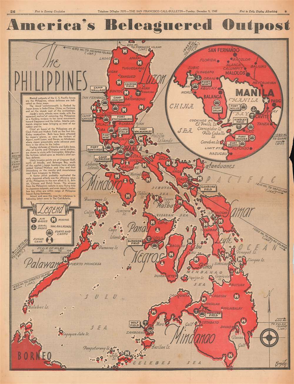
America's Beleaguered Outpost. The Philippines.
1941 (dated) 20.25 x 15.25 in (51.435 x 38.735 cm) 1 : 3168000
1941 (dated) 20.25 x 15.25 in (51.435 x 38.735 cm) 1 : 3168000
Description
Published on December 9, 1941, this Bannister map of the Philippines likely introduced many of The San Francisco Call-Bulletin's readers to the archipelago. The Japanese attacked the American Pacific Fleet at Pearl Harbor on December 7 and American bases in the Philippines on December 8, pushing the United States into a war that it had long wanted to avoid. The archipelago's major islands are all labeled along with many of its major cities, including Manila, Davao, Cebu, and Iloilo. Icons mark air and naval bases, mining regions, railroads, American forts and camps, and, curiously, areas cultivating sugar cane. A circular inset in the upper right focuses on Manila, Manila Bay, and the immediate vicinity, placing particular importance on American military installations. Corregidor Island at the mouth of Manila Bay is prominently labeled and would play a critical role during the coming Japanese invasion.
The Japanese Strategy in the Philippines
The capture and control of the Philippines was vital to the success of Japanese plan to dominate the Pacific. Not only was the archipelago rich in natural resources, including rubber, oil, mineral resources, and wood, it was also centrally located and well positioned for expansion into the East Indies. Moreover, wresting control of the Philippines from the United States would have effectively undermined the American ability to wage war in the region. The Japanese invasion of the Philippines commenced on December 8, 1941, one day after the December 7th, 1941 bombing of Pearl Harbor (although technically the same day because of the International Date Line). While Japanese forces advanced quickly through the archipelago, like the Spanish before them, they promptly discovered that the hundreds of islands and limited infrastructure made the Philippines almost impossible to fully control. Nonetheless, the Japanese maintained a tenuous control of most of the Philippine Islands until 1944, when the U.S. led Allied Forces began an aggressive and bloody campaign to retake the islands. Allied forces successfully drove the Japanese out of the Philippines in 1945.Publication History and Census
This map was drawn by Bannister and published in the Tuesday, December 9, 1941 edition of The San Francisco Call-Bulletin. We have not been able to trace another example.Condition
Very good. Newsprint. Close right margin. Exhibits light wear along original fold lines. Text on verso.