This item has been sold, but you can get on the Waitlist to be notified if another example becomes available, or purchase a digital scan.
1942 Japanese Ethnographic Map of the Philippines
PhilippinesEthnographic-japanese-1942$250.00

Title
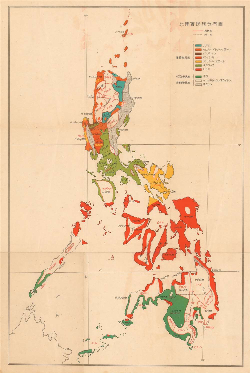
National Distribution Map of Philippines. / 比律賓民族分布圖
1942 (undated) 22.25 x 14.5 in (56.515 x 36.83 cm) 1 : 3539000
1942 (undated) 22.25 x 14.5 in (56.515 x 36.83 cm) 1 : 3539000
Description
A curious map c. 1942 Japanese WWII era ethnographic of the Philippines dividing the archipelago according to ethnic, linguistic, and religious groups. Color coding distinguishes between 10 different ethnic and linguistic groups. These groups are further subdivided into Christians, Muslims, and Other non-Christian religions. Among the ethnic / language groups represented are the Eastern Ilocano (Gray, northeastern Luzon), Western Ilocano (Orange, northeastern Luzon), Tagalog (Green, central Luzon), Bicolano (Red, southern Luzon), Cebuano (Red), and more.
The Japanese Strategy in the Philippines
The capture and control of the Philippines was vital to the success of Japanese plans to dominate the Pacific. Not only was the archipelago rich in natural resources, including rubber, oil, mineral resources, and wood, it was also centrally located and well-positioned for expansion into the East Indies. Moreover, wresting control of the Philippines from the United States would effectively undermine the American ability to wage war in the region. The Japanese invasion of the Philippines commenced on December 8, 1941, one day after the December 7th, 1941 bombing of Pearl Harbor. While Japanese forces advanced quickly through the archipelago, like the Spanish before them, they promptly discovered that the hundreds of islands and limited infrastructure made the Philippines almost impossible to fully control. Nonetheless, the Japanese maintained a tenuous control of most of the Philippine Islands until 1944, when the U.S. led Allied Forces began an aggressive and bloody campaign to retake the islands. Allied forces successfully drove the Japanese out of the Philippines in 1945.Publication History and Census
It is unclear when and where this map was issued. We can only speculate that it emerged in 1942, when the Japanese controlled most of the Philippines. No other known examples.Condition
Good. Original fold lines. Minor toning.