This item has been sold, but you can get on the Waitlist to be notified if another example becomes available, or purchase a digital scan.
1960 Trabacchi Pictorial Map of Rome, Italy
PiantaRoma-trabacchi-1960$150.00

Title
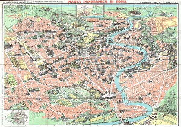
Pianta Panoramica di Roma.
1960 (undated) 27 x 30 in (68.58 x 76.2 cm)
1960 (undated) 27 x 30 in (68.58 x 76.2 cm)
Description
This is a beautiful c.1960 panoramic view map of Rome, Italy. It covers the 'Eternal City' in incredible detail, revealing individual streets, parks, historic buildings, piazzas, temples, ancient ruins, bridges, rivers and ecclesiastical centers. Known as the birthplace of western civilization, Rome was the capital of the Roman Empire. The map includes about 50 of Roma's most important monuments and building depicted in profile. The lower left quadrant includes an inset of E.U.R while another inset of Lido di Roma (Ostia) is included below the title. Verso features a street map of Rome with transportation details along with an index of the monuments and principal buildings located on the map. With text in Italian, Spanish, French, German and English, this map was drawn by Augusto Trabacchi and was published by Mauro Gigli with graphics art by Panetto & Petrelli.
Condition
Very good. Minor wear along original fold lines. Street map on verso.