This item has been sold, but you can get on the Waitlist to be notified if another example becomes available, or purchase a digital scan.
1933 H. Boylston Dummer Pictorial Map of Nazi Germany
PictureMapNaziGermany-dummer-1933$200.00

Title
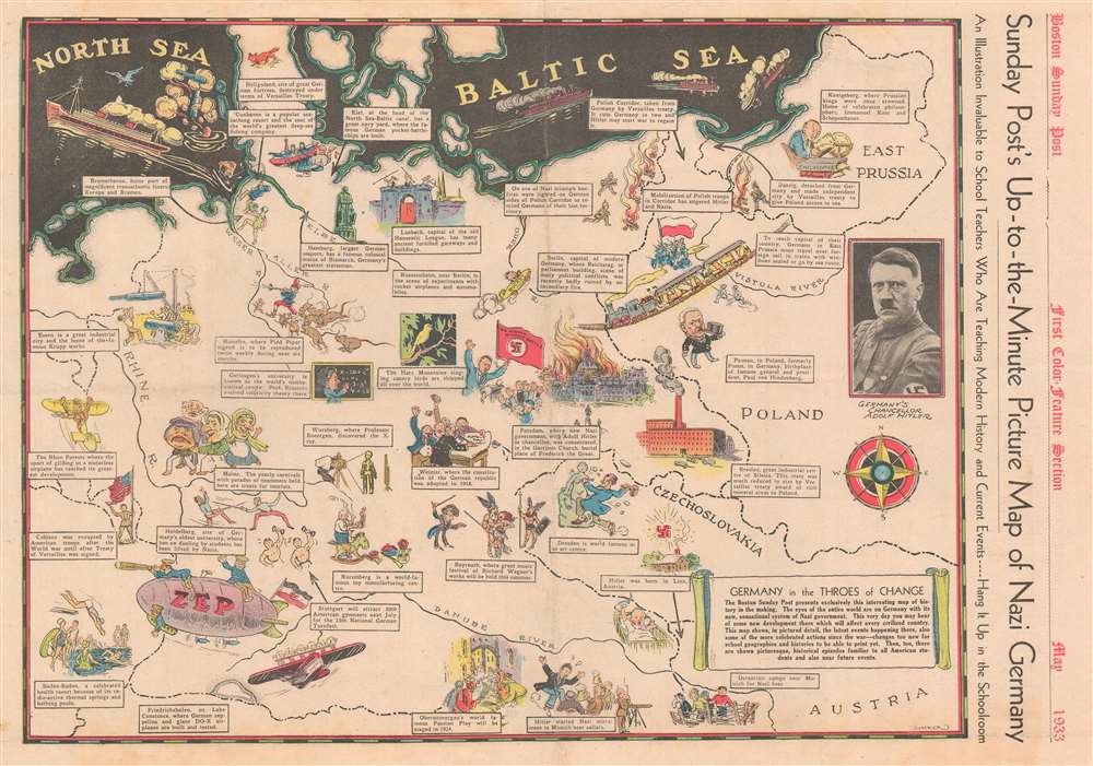
Sunday Post's Up-to-the-Minute Picture Map of Nazi Germany.
1933 (dated) 15.25 x 21.75 in (38.735 x 55.245 cm)
1933 (dated) 15.25 x 21.75 in (38.735 x 55.245 cm)
Description
This 1933 H. Boylston Dummer pictorial map of Nazi Germany is both fascinating and disturbing. Published a little less than two months after the passage of the Enabling Act on March 24, 1933 effectively made Hitler the dictator of Germany, Dummer's map presents the reality of life in Nazi Germany in the spring of 1933 while at the same time highlighting many of Germany's best cultural and historical attributes, with the stated goal of helping teachers present current events to their students. Illustrations of Hitler firing up an audience in a beer hall in Munich and of a Nazi detention camp near Munich (probably Dachau) appear alongside vignettes of Oberammergau's Passion Play, craftsmen building toys in Nuremberg, and people vacationing in the spa town of Baden-Baden. Einstein, Kant, and Schopenhauer are all drawn or referenced, while a celebratory Hitler speaks to a crowd in Potsdam next to a burning Reichstag. A photographic portrait of Hitler is also printed along the right border.
This Map and the Versailles Treaty Ending World War I
Numerous references are also made to the punishments suffered by Germany after the Versailles Treaty was signed ending World War I. An American solider appears in Koblenz holding an American flag, illustrating the American occupation of the city after the war, while textboxes inform the viewer of a destroyed fortress at Heligoland, and the creation of the Polish Corridor, a potential flash point of conflict between the rising Nazis and the Polish. Perhaps the whole map is best summarized by the short text that appears in the lower right corner:The Boston Sunday Post presents exclusively this interesting map of history in the making. The eyes of the world are on Germany with its new, sensational system of Nazi government. This very day you may hear of some new development there which will affect every civilized country. This map shows, in pictured detail, the latest events happening there, also some of the more celebrated actions since the war - changes too new for school geographies and histories to be able to print yet. Then, too, there are shown picturesque, historical episodes familiar to all American students and also new future events.Publication History and Census
This map was created by H. Boylston Dummer and published in the May 21, 1933 edition of the Boston Sunday Post. This is the only known surviving example.
Cartographer
H. Boylston Dummer (October 19, 1878 - November 3, 1945) was an American artist, illustrator, painter, and teacher. Born in Rowley, Massachusetts, Dummer attended the Governor Dummer Academy, founded by members of his family, before taking up art. He studied art at the Eric Pape School of Art in Boston, the Grand Central School of Art in New York City, and the Carbee Art School in Boston. He was a member of the art department of the Boston Sunday Post for many years and was best known for his illustrations of the 'Bingville Bugle'. Dummer's illustrations also appeared in the weekly children's magazine The Youth's CompanionHe was married to his wife Nellie with whom he had one daughter. More by this mapmaker...
Condition
Very good. Newsprint. Closed margin tears professionally repaired on verso. Text and printed images on verso.