This item has been sold, but you can get on the Waitlist to be notified if another example becomes available, or purchase a digital scan.
1892 Walker Railroad Commission Map of Massachusetts
RailroadsMassachusetts-walker-1892$250.00

Title
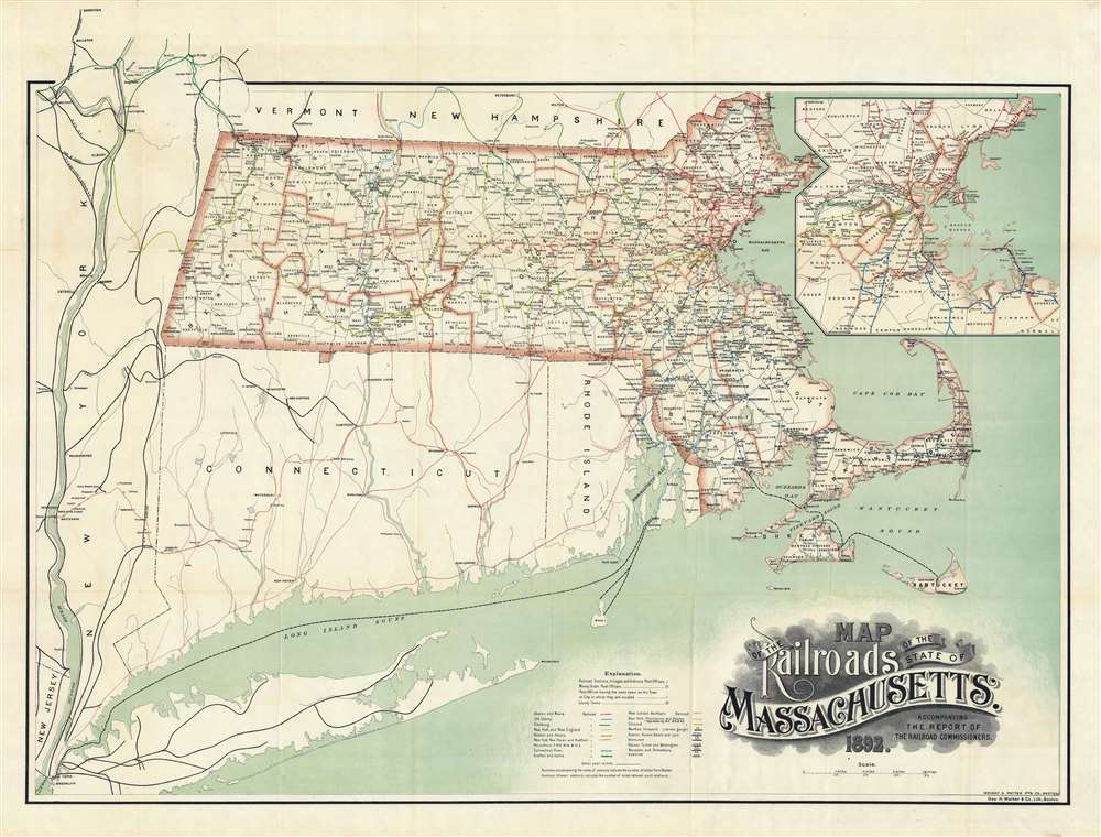
Map of the Railroads of the State of Massachusetts.
1892 (dated) 27 x 35.5 in (68.58 x 90.17 cm) 1 : 443520
1892 (dated) 27 x 35.5 in (68.58 x 90.17 cm) 1 : 443520
Description
An uncommon and striking 1892 3-color chromolithograph map of Massachusetts illustrating railroad development throughout the state. The map covers the entire state, with 17 different railroad company routes defined using a combination of color and pattern coding. A large inset in the upper right details the dense greater Boston metropolitan area. The map offers additional coverage to the Hudson Valley and southwest to New York City, illustrating important commercial and passenger connections. The finely engraved title block, appearing in the lower right, stands out for its masterful execution.
Chromolithography
Chromolithography is a color lithographic technique developed in the mid-19th century. The process involved using multiple lithographic stones, one for each color, to yield a rich composite effect. Oftentimes, the process would start with a black basecoat upon which subsequent colors were layered. Some chromolithographs used 30 or more separate lithographic stones to achieve the desired effect. Chromolithograph color could also be effectively blended for even more dramatic results. The process became extremely popular in the late 19th and early 20th centuries, when it emerged as the dominant method of color printing. The vivid color chromolithography produced made it exceptionally effective for advertising and propaganda imagery.Publication History and Census
This map was engraved by George Walker and printed by Wright and Potter, both of Boston, for issue in the 1892 Report of The Railroad Commissioners. The map is scarce despite being issued in various editions over several years. The earliest edition we have been able to find is 1891, and the latest 1909. The map is well represented institutionally in various states, but we have not found another 1892 example.Cartographer
George Hiram Walker (January 4, 1852 - November 14, 1927) was a Boston based publisher of books, views, and maps active in the late 19th and early 20th centuries. Born in Springfield, Vermont, Walker started his life as a dry goods merchant but developed an active interest in publishing during the early 1870s. Walker began publishing in 1878 when he partnered with an unknown New York Firm. Two years later, Walker brought the operation in house by partnering with his brother, Oscar W. Walker, in the opening of a lithography studio at 81 Milk Street, Boston. Shortly thereafter the firm expanded to new offices at 160 Tremont Street, Boston. The Walker brothers produced a large corpus of works, most of which focused on travel and tourism in New England. Walker also established the Walker-Gordon Milk Laboratory with Dr. Thomas Morgan Rotch and Gustave Gordon. This interesting investment was based on the premise that infant deaths could be avoided by providing higher quality milk. The company eventually became a great success, producing a high-quality cow milk that closely resembled human breast milk. In the process the Walker-Gordon laboratory developed many of the dairy health standards that are still with us today. Walker married Irene L. Loud on March 25, 1885. More by this mapmaker...
Condition
Very good. Slight wear on old fold lines.
References
Boston Public Library, Leventhal, G3761.P3 1897 .M3x. OCLC 159940857.