This item has been sold, but you can get on the Waitlist to be notified if another example becomes available, or purchase a digital scan.
1721 Chatelain Plan or Map of Rome, Italy
Rome-chatelain-1720$200.00

Title
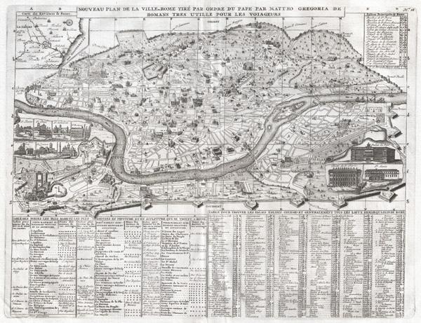
Nouveau Plan dela Ville de Rome Tire Par Ordre du Pape Par Matteo Gregoria de Romans Tres utille Pour Les Voiageurs.
1721 (undated) 13.5 x 17.5 in (34.29 x 44.45 cm)
1721 (undated) 13.5 x 17.5 in (34.29 x 44.45 cm)
Description
A highly detailed 1721 map of Rome and a splendid example of Henri Chatelain's magnificent engraving. Covers the walled center of Rome on either side of the Tiber from the Porta del Popolo to the Porta St. Paola. Shows major streets with important buildings, including the Vatican, Coliseum, Pantheon, and numerous other monuments drawn in profile. The lower quadrants of the map are occupied by extensive tabular data relating to various constructions and the history of Rome. There are ten inset views showing important Roman buildings, these include: St. Pierre, St. Paul, St. Sebastian, St. Bastiane, St. Crois de Jerusalem, St. Lorenzo and St. Marie Maggior, the Palaise du Pape, the Palais de St. Pierre, and St. Marie. A further inset map in the upper left quadrant shows Rome's situation relative to nearby cities and the Mediterranean. Engraved by Henri de Chatelain for volume 1 of the 1721 issue of theAtlas Historique.
Cartographer
Henri Abraham Chatelain (1684 - 1743) was a Huguenot pastor of Parisian origins. He lived consecutively in Paris, St. Martins, London (c. 1710), The Hague (c. 1721) and Amsterdam (c. 1728). He is best known as a Dutch cartographer and more specifically for his cartographic contribution in the seminal seven volume Atlas Historique, published in Amsterdam between 1705 and 1720. Innovative for its time, the Atlas Historique combined fine engraving and artwork with scholarly studies of geography, history, ethnology, heraldry, and cosmography. Some scholarship suggests that the Atlas Historique was not exclusively compiled by Henri Chatelain, as is commonly believed, but rather was a family enterprise involving Henri, his father Zacharie and his brother, also Zacharie. More by this mapmaker...
Source
Chatelain, H. A., Atlas Historique, vol. 1, 1721 edition.
Condition
Very good. Original centerfold. Pressmark visible. Blank on verso.