This item has been sold, but you can get on the Waitlist to be notified if another example becomes available, or purchase a digital scan.
1721 John Senex Map of Rome
Rome-sennex-1721$800.00

Title
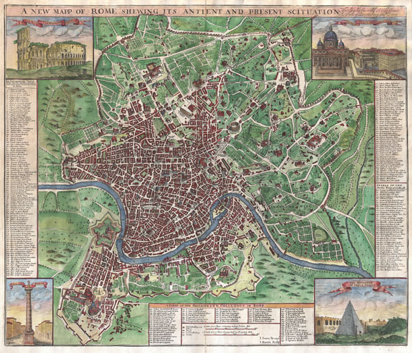
A New Mapp of Rome Shewing Its Antient And Present Scituation. Most Humbly Inscribed to His Grace The Duke of Queensbury and Dover.
1721 (undated) 20 x 23 in (50.8 x 58.42 cm)
1721 (undated) 20 x 23 in (50.8 x 58.42 cm)
Description
A radiant full color example of John Sennex's 1721 map of Rome. Covers the entire and part of the surrouding countryside. Identifies both modern and ancient monuments in profile. Some of these include the Coliseum, the Vatican, the Pantheon, and various other monument s, monasteries, and churches. Each corner is decorated with an engraved image of an important Roman monument, including: the 'Ruins of ye Amphitheater of Vespatian,' 'St. Peter's Church & ye Pope's Pallace,' 'Trajan's Pillar,' and the pyramidal 'Sepulcher of Caijus Cestus.' Engraved for John Sennex by John Harris and Samual Parker.
Cartographer
John Senex (1678 - 1740) was an English engraver and map maker active in London during the first half of the 18th century. Senex was born to upper middle class parents in Shropshire, England. As a young man, he was apprenticed to Robert Clavell, a London bookseller and member of the Stationers' Company, under whom he mastered the arts of engraving and printmaking. Around 1702 Senex completed his apprenticeship and established himself as a printer and bookseller in the Strand. A year later Senex partnered with Jeremiah Seller and Charles Price, the successors to the important mapmaker John Seller, and relocated to Cornhill. This was likely Senex's first introduction to mapmaking though he seems to have taken to it with abandon. In the subsequent years Senex established himself as one of the most prominent cartographers in London, publishing a number of beautiful and important maps that today rank among the finest examples from the Golden Age of British Cartography. In addition to a large corpus of flat maps, Senex also produced a number of important and highly desirable globes. Eventually Senex dissolved his partnership with Seller and Price and relocated to Fleet Street, where he maintained offices until his death in 1740. Senex was succeeded by his widow, Mary Senex, who continued to publish and update his works until about 1755, when the remaining globe and map plates were sold to James Ferguson. More by this mapmaker...
Condition
Very good condition. Original centerfold. Mild buckling to paper.