This item has been sold, but you can get on the Waitlist to be notified if another example becomes available, or purchase a digital scan.
1762 Janvier Map of Scandinavia - Sweden, Norway, Denmark, Finland
Scandinavia3-janvier-1762$125.00

Title
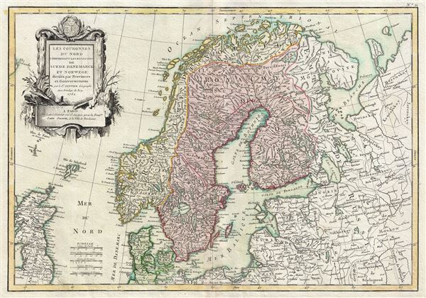
Les Couronnes du Nord Comprenant les Royaumes de Suede Danemarck et Norwege divises par Provinces et Gouvernemens.
1762 (dated) 12.5 x 18 in (31.75 x 45.72 cm) 1 : 6900000
1762 (dated) 12.5 x 18 in (31.75 x 45.72 cm) 1 : 6900000
Description
This is a beautiful example of Jean Janvier's 1762 decorative map of Scandinavia. It covers from Iceland and England eastward as far as Moscow, north to the Arctic Sea, and south as far as Denmark and Germany and includes the modern day nations of Sweden, Denmark, Norway, and Finland. Towns, cities, rivers, mountains, and some undersea features are identified.
Of particular interest is the legendary Lofoten Maelstrom (Mael-Stroom) in northwestern Norway. This legendary whirlpool was the inspiration for Edgar Allen Poe's classic tale 'Descent into the Maelstrom.' In reality, it is a periodic and powerful current caused by tidal variations in the region.
A large decorative title cartouche appears in the upper left quadrant of the map. This map was drawn by J. Janvier and included as plate no. 21 in the first edition of Jean Lattre's 1762 issue of the Atlas Moderne.
CartographerS
Jean Denis Janvier (fl. 1746 - 1776), sometime also known as 'Robert', was a Paris based cartographer active in the mid to late 18th century. Janvier signed his maps Signor Janvier. By the late 18th century, Janvier was awarded the title of 'Geographe Avec Privilege du Roi' and this designation appears on many of his later maps. Janvier worked with many of the most prominent French, English and Italian map publishers of his day, including Longchamps, Faden, Lattre, Bonne, Santini, Zannoni, Delamarche, and Desnos. More by this mapmaker...
Jean Lattré (170x - 178x) was a Paris based bookseller, engraver, globe maker, calligrapher, and map publisher active in the mid to late 18th century. Lattré published a large corpus of maps, globes, and atlases in conjunction with a number of other important French cartographic figures, including Janvier, Zannoni, Bonne and Delamarche. He is also known to have worked with other European cartographers such as William Faden of London and the Italian cartographer Santini. Map piracy and copyright violations were common in 18th century France. Paris court records indicate that Lattré brought charges against several other period map publishers, including fellow Frenchman Desnos and the Italian map engraver Zannoni, both of whom he accused of copying his work. Lattré likes trained his wife Madame Lattré (né Vérard), as an engraver, as a late 18th century trade card promotes the world of 'Lattré et son Epouse.' Lattré's offices and bookshop were located at 20 rue St. Jaques, Paris, France. Later in life he relocated to Bordeaux. Learn More...
Source
Lattre, Jean, Atlas Moderne ou Collection de Cartes sur Toutes les Parties du Globe Terrestre Par Plusieurs Auteurs, Paris, 1762.
Condition
Very good. Original platemark visible. Minor wear along original centerfold. Blank on verso.
References
Rumsey 2612.043. Phillips (Atlases) 664. National Maritime Museum, 215.