This item has been sold, but you can get on the Waitlist to be notified if another example becomes available, or purchase a digital scan.
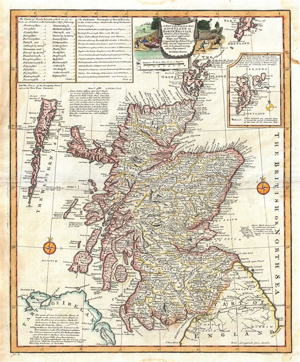
1747 Bowen Map of Scotland
Scotland-bowen-1747$250.00

Title
A New and Accurate Map of Scotland or North Britain.
1747 (undated) 18 x 14.5 in (45.72 x 36.83 cm) 1 : 1500000
1747 (undated) 18 x 14.5 in (45.72 x 36.83 cm) 1 : 1500000
Description
An attractive 1747 map of Scotland or North Britain, by the British cartographer Emanuel Bowen. It covers Scotland including the Western Islands or the Outer Hebrides and the Orkney Islands. The Shetland Islands are featured in an inset along the right border. This extremely detailed map notes important towns, shires, boroughs, cities, roads, etc. River systems are well delineated and forests and topography and rendered in profile. Bowen includes several interesting notes of discovery throughout the map, including 'Marr's Bank discovered by a Celebrated Navigator of that name. Plenty of Cod Fish and Ling caught all about this Bank' and 'Dangerous Rocks first discovered by Capt. Mills 1731.' Another note, 'Y Columb Kill Island the burial place of 60 Kings' most likely refers to the Island of Iona, located few miles off the coast of Mull, Scotland and approximately 80 miles from Ireland. This is where, in 563 BC, St. Columbkille sailed to with 12 companions, and built his monastery. The monastery would go on to become the burial place of all the Scottish kings until the 11th century. A note in the bottom left quadrant of the map explains the compilation of the map, while the upper left quadrant includes a list of Shires and Parliament Buroughs of North Britain. A beautifully illustrated title cartouche depicts scenes of hunting. This map was prepares by Emanuel Bowen as plate no. 8 for the 1747 issue of A Complete System of Geography.
Cartographer
Emanuel Bowen (1694 - May 8, 1767) had the high distinction to be named Royal Mapmaker to both to King George II of England and Louis XV of France. Bowen was born in Talley, Carmarthen, Wales, to a distinguished but not noble family. He apprenticed to Charles Price, Merchant Taylor, from 1709. He was admitted to the Merchant Taylors Livery Company on October 3, 1716, but had been active in London from about 1714. A early as 1726 he was noted as one of the leading London engravers. Bowen is highly regarded for producing some of the largest, most detailed, most accurate and most attractive maps of his era. He is known to have worked with most British cartographic figures of the period including Herman Moll and John Owen. Among his multiple apprentices, the most notable were Thomas Kitchin, Thomas Jeffreys, and John Lodge. Another apprentice, John Oakman (1748 - 1793) who had an affair with and eventually married, Bowen's daughter. Other Bowen apprentices include Thomas Buss, John Pryer, Samuel Lyne, his son Thomas Bowen, and William Fowler. Despite achieving peer respect, renown, and royal patronage, Bowen, like many cartographers, died in poverty. Upon Emanuel Bowen's death, his cartographic work was taken over by his son, Thomas Bowen (1733 - 1790) who also died in poverty. More by this mapmaker...
Source
Bowen, E., A complete system of geography. Being a description of all the countries, islands, cities, chief towns, harbours, lakes, and rivers, mountains, mines, etc., of the known world …, (London) 1747.
Condition
Very good. Minor wear and toning along original centerfold. Original platemark visible. Minor damp stains in upper and lower margins, not extending onto printed area.
References
Rumsey 3733.007. Philips (atlases) 614 (1752 edition).