This item has been sold, but you can get on the Waitlist to be notified if another example becomes available, or purchase a digital scan.
1801 Cary Map of Scotland (4 Sheets)
Scotland-cary-1801$300.00

Title
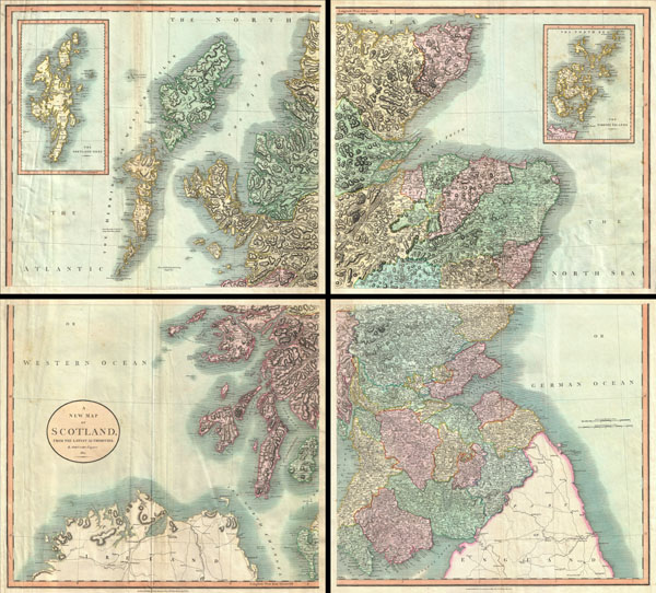
A New Map of Scotland.
1801 (dated) 35 x 40 in (88.9 x 101.6 cm)
1801 (dated) 35 x 40 in (88.9 x 101.6 cm)
Description
A very attractive example of John Cary's stupendous four sheet 1801 map of Scotland. Covers the entirety of Scotland as well as parts of neighboring England and Ireland. Inset maps detail the Orkney Islands and the Shetland Islands. Offers extraordinary detail on the whole of Scotland with special attention to topography, historical notations, and roadways. Note mileage. Four sheets designed to be united into a single massive wall map of Scotland see the Rumsey example, 1675.011. All in all, one of the largest and most highly detailed maps of Scotland to appear in first years of the 19th century. Prepared in 1799 by John Cary for issue in his magnificent 1808New Universal Atlas.
Cartographer
John Cary (1754 - 1835) was a London based cartographer active in the early part of the 19th century. Ronald Vere Tooley, the prominent English map historian, writes of Cary, "As an engraver he was elegant and exact with fine clear lettering and great delicacy of touch." Cary began his work as an engraver, cartographer, and globe maker in 1776 with his New and Correct English Atlas. This important atlas represented a new phase in cartography where accuracy and detail rose in prominence over the decorative embellishments of the 18th century. This change was indicative of the times when travel and commerce were expanding globally as never before. Cary's mastery of both engraving and cartography resulted in a series of seminal works that redefined mapmaking in the early 19th century. His stupendous Cary's New Universal Atlas, published in 1808, set the standard for all cartographers who followed. Cary reissued this seminal atlas in 1811, 1819, 1824, 1828, 1833, 1836 and 1844. Cary also did considerable work on the English Ordinance Survey prior to 1805. His cartographic work particularly inspired the Edinburgh school of cartography as represented by John Pinkerton and John Thomson. In America, Cary's work was used as the basis for Tanner's important New American Atlas. Cary's last published atlas appeared posthumously in 1844, however, by 1850 Cary's work was being carried on by his sons and other well-known cartographers including James Wyld, John Tallis & Company, and Crutchley. More by this mapmaker...
Source
Cary, John, Cary's New Universal Atlas, containing distinct maps of all the principal states and kingdoms throughout the World. From the latest and best authorities extant. London: Printed for J. Cary, Engraver and Map-seller, No. 181, near Norfolk Street, Strand, 1808.
Condition
Good condition. Printed on four separate sheets. Some sheets exhibit minor wrinkling and certerfold discoloration. Designed to be assembed into a single gigantic wall map of Scotland. Unjoined but priced to accomidate this as well as minor restoration and conservation work.
References
Rumsey 1657.011 (joined example). Phillips (Atlases) 714. The Map Collector, issue 43, p. 40-47 (Atlas). National Maritime Museum, v. 3, no. 311.