1736 Owen / Bowen Map of Somersetshire w/ Road Map: Chester to Cardiff on verso
Somersetshire-ogilby-1736$175.00

Title
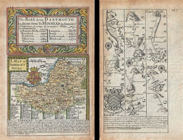
A Map of Somerset Shire. The Road from Darmouth in Devon Shire to Minhead in Somerset S.
1736 (undated) 7.5 x 5 in (19.05 x 12.7 cm) 1 : 633600
1736 (undated) 7.5 x 5 in (19.05 x 12.7 cm) 1 : 633600
Description
This is a scarce 1736 example of John Owen and Emanuel Bowen's map of the County of Somerset, England. The map is printed on both sides. The map on recto features a detailed map of the County of Somerset (commonly known as Somersetshire until the late 19th century) with a decorative title cartouche. Detailed information about Somersetshire is included along the bottom of the map proper. The armorial crest of the Duke of Somerset is also included. Verso features the three strip road map from Chester to Cardiff and notes several towns along the way. Rivers, bridges, forests, and other topographical details are also noted. Each strip map contains a compass rose and notes distances, in miles. This map also features information about Cardiff along the bottom of the map along with a Coat of Arms of Cardiff. Issued as page nos. 167 and 168 in Britannia depicta, or, Ogilby improv'd.
Cartographer
Emanuel Bowen (1694 - May 8, 1767) had the high distinction to be named Royal Mapmaker to both to King George II of England and Louis XV of France. Bowen was born in Talley, Carmarthen, Wales, to a distinguished but not noble family. He apprenticed to Charles Price, Merchant Taylor, from 1709. He was admitted to the Merchant Taylors Livery Company on October 3, 1716, but had been active in London from about 1714. A early as 1726 he was noted as one of the leading London engravers. Bowen is highly regarded for producing some of the largest, most detailed, most accurate and most attractive maps of his era. He is known to have worked with most British cartographic figures of the period including Herman Moll and John Owen. Among his multiple apprentices, the most notable were Thomas Kitchin, Thomas Jeffreys, and John Lodge. Another apprentice, John Oakman (1748 - 1793) who had an affair with and eventually married, Bowen's daughter. Other Bowen apprentices include Thomas Buss, John Pryer, Samuel Lyne, his son Thomas Bowen, and William Fowler. Despite achieving peer respect, renown, and royal patronage, Bowen, like many cartographers, died in poverty. Upon Emanuel Bowen's death, his cartographic work was taken over by his son, Thomas Bowen (1733 - 1790) who also died in poverty. More by this mapmaker...
Source
Owen, J. and Bowen, E., Britannia depicta, or, Ogilby improv'd : being a correct coppy of Mr. Ogilby's actual survey of all ye direct & principal cross roads in England & Wales, 1736.
Condition
Very good. Minor toning. Original platemark visible. Printed on both sides.