This item has been sold, but you can get on the Waitlist to be notified if another example becomes available, or purchase a digital scan.
1800 Schoolgirl Map of the Southern Hemisphere
SouthernHemisphere-ivessallym-1830$175.00

Title
Southern Hemisphere Sally M. Ives.
1830 (undated) 5.5 x 6 in (13.97 x 15.24 cm)
1830 (undated) 5.5 x 6 in (13.97 x 15.24 cm)
Description
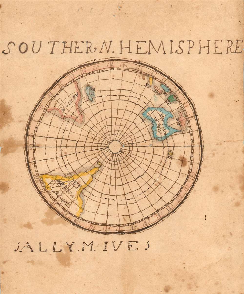
This is a charming, if inexpert schoolgirl map of the Southern Hemisphere, an unusual focus for works of this kind. The map dates from the first part of the 19th century, predating both the discovery of Terra Firma in Antarctica, and the conventional use of the name 'Australia' in preference to 'New Holland.' The map is in English and probably the work of an American student. As is typical with this sort of map, the work is signed - by a miss Sally M. Ives- but sadly we are unable to trace so common a name. There were many Iveses in New England, and many Sallys among them.
The goals of these exercises were more far-reaching than teaching geography. Students were encouraged to take pains in their draftsmanship, and often achieved beautiful flourishes of artistic expression. (As with any student work, the ideals were not always achieved.) But most peculiar to the American iterations of educational mapping was the goal of instilling a sense of civic pride and responsibility. Indeed, the key desired result of education in the post-Revolutionary-War United States was to prepare for the education of the next generation of American citizens, a patriotic duty. For a good overview, see Betty Mason's '19th Century Schoolgirls Were Incredibly Good at Drawing Maps.' Published July 27, 2016 by National Geographic.
Map Details
South America is shown including Tierra del Fuego. The Amazon is labeled, although Miss Ives's penmanship is challenging. New Holland (Australia) is shown, but New Zealand is absent. There is an island labeled C - A, possibly indicating New Caledonia, or the Queen Charlotte Archipelago. Ms. Ives' contractions do appear to be somewhat arbitrary. We see this several times amongst the spice islands: Papua New Guinea as 'PA', CS for the Celebes, BO for Borneo, JA and SA for Java and Sumatra respectively. East of Africa, MR identifies Madagascar.Schoolboy / Schoolgirl Maps
The use of mapmaking in teaching is first seen in Europe, mainly England, but thereafter the Schoolgirl/boy Map became a peculiarly American pedagogical tool in the first part of the 19th Century. Such maps can show remarkably fine execution, but are often beloved more for their idiosyncratic lettering, and other homespun flourishes. They most often illustrate the World, the United States, New England, or specific states. The present example, focusing on the southern hemisphere, is notable for what it does not display: there is no hint, here, of Antarctica, placing the map before the famous discoveries of the 19th century that would certainly gain mention on such a map. That said, most schoolgirl maps were based on generally available reference maps, such as those found in the atlases produced by Carey and Lea, Finley, and Mitchell. Though these may have been the best sources available a student, they were not always markedly up-to-date.The goals of these exercises were more far-reaching than teaching geography. Students were encouraged to take pains in their draftsmanship, and often achieved beautiful flourishes of artistic expression. (As with any student work, the ideals were not always achieved.) But most peculiar to the American iterations of educational mapping was the goal of instilling a sense of civic pride and responsibility. Indeed, the key desired result of education in the post-Revolutionary-War United States was to prepare for the education of the next generation of American citizens, a patriotic duty. For a good overview, see Betty Mason's '19th Century Schoolgirls Were Incredibly Good at Drawing Maps.' Published July 27, 2016 by National Geographic.
Condition
Good. Manuscript, pen, and hand colors. Some stains, wear at folds and corners. Else very good for this kind.