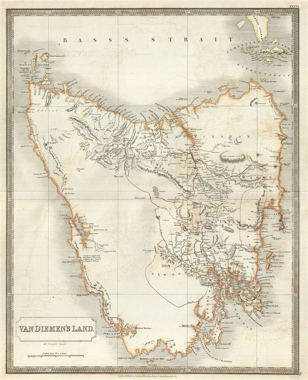
A beautiful map of the colony of Tasmania or Van Diemen's Land, Australia, from Sidney Hall's extremely scarce 1835 New General Atlas. The map covers the entire island of Tasmania as well as nearby Flinders Island (Great Island). This map exists in several known states, the present example being the second. This edition incorporates the results of numerous expeditions into the interior, an updated county system, and reveals an increasingly sophisticated internal road system. The map bears a number of interesting annotations including a comment describing how 'convicts are transported form Hobert Town to the settlement upon Sarah's I. in Macquarie Harbour.' As this map was printed Tasmania was being aggressively colonized as a Penal Colony under the name 'Van Diemen's Land,' referring to the Dutch East India Company governor who sponsored Tasman's historic 1642 discovery of the island. The genocide of the Tasman aboriginal population also reached its tragic conclusion in this year, 1835, and the few reaming full blooded aborigines were transported to the 'sanctuary' of Flinder's Island. This is one of the few published maps of Tasmania from this period and an important record of the early development of the colony. A cornerstone map for any serious Tasmania collection.
Sidney Hall's New General Atlas was published from 1830 to 1857, the first edition being the most common, with all subsequent editions appearing only rarely. Most of the maps included in the first edition of this atlas were drawn between 1827 and 1828 and are most likely steel plate engravings, making it among the first cartographic work to employ this technique. Each of the maps in this large and impressive atlas feature elegant engraving and an elaborate keyboard style border. Though this is hardly the first map to employ this type of border, it is possibly the earliest to use it on such a large scale. Both the choice to use steel plate engraving and the addition of the attractive keyboard boarder are evolutions of anti-forgery efforts. Copper plates, which were commonly used for printing bank notes in the early 19th century, proved largely unsuitable due to their overall fragility and the ease with which they could be duplicated. In 1819 the Bank of England introduced a £20,000 prize for anyone who could devise a means to print unforgeable notes. The American inventors Jacob Perkins and Asa Spencer responded to the call. Perkins discovered a process for economically softening and engraving steel plates while Spencer invented an engraving lathe capable of producing complex patters repetitively - such as this keyboard border. Though Perkins and Spenser did not win the prize, their steel plate engraving technique was quickly adopted by map publishers in England, who immediately recognized its value. Among early steel plate cartographic productions, this atlas, published in 1830 by Longman Rees, Orme, Brown & Green stands out as perhaps the finest. This map was issued by Sidney Hall and published by Longman Rees, Orme, Brown & Green of Paternoster Row, London, in the 1835 edition of the Sidney Hall New General Atlas.
Cartographer
Sidney Hall (1788 - 1831) was an English engraver and map publisher active in London during the late 18th and early 19th centuries. His earliest imprints, dating to about 1814, suggest a partnership with Michael Thomson, another prominent English map engraver. Hall engraved for most of the prominent London map publishers of his day, including Aaron Arrowsmith, William Faden, William Harwood, and John Thomson, among others. Hall is credited as being one of the earliest adopters of steel plate engraving, a technique that allowed for finer detail and larger print runs due to the exceptional hardness of the medium. Upon his early death - he was only in his 40s - Hall's business was inherited by his wife, Selina Hall, who continued to publish under the imprint, "S. Hall", presumably for continuity. The business eventually passed to Sidney and Selina's nephew Edward Weller, who became extremely prominent in his own right. More by this mapmaker...
Source
Hall, S., A New General Atlas, with the Divisions and Boundaries, 1835.
Very good. Minor wear along original centerfold. Original platemark visible. Blank on verso. Minor offsetting.
Rumsey 4224.037 (1830 edition). Tooley, R.V., The mapping of Australia and Antarctica, 2nd ed., p. 92-93, no 687. Philips (Atlases) 758. National Library of Australia, 2113921; MAP F 514; MAP NK 10750/1; MAP RM 741; MAP T 687. Ristow, W., American Maps and Mapmakers: Commercial Cartography in the Nineteenth Century, p. 303-09.