This item has been sold, but you can get on the Waitlist to be notified if another example becomes available, or purchase a digital scan.
1883 McNally Railroad Map of United States
UnitedStatesCanada-mcnally-1883$150.00

Title
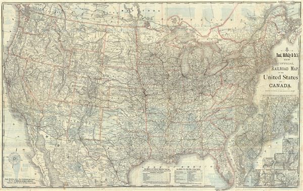
New Official Railroad Map of The United States And Canada.
1883 (dated) 27.5 x 43.5 in (69.85 x 110.49 cm)
1883 (dated) 27.5 x 43.5 in (69.85 x 110.49 cm)
Description
This is a fine example of Rand McNally's 1883 railroad map of the United States. This map covers all of the United States and the southeastern provinces of Canada. Nine inset maps in the lower right quadrant include a map of Atlantic coast states engraved on an enlarged scale, Boston, New York, Philadelphia, Cincinnati, St. Louis, Chicago, Buffalo & Niagara Falls, and Washington. The map is highly detailed and notes cities, towns and counties. The map is hand colored outlines to define state boundaries with relief shown in hachures. Various advertisements from the period appear on verso. The map is dated and copyrighted 1883 and was published by Rand McNally & Co., Chicago.
Cartographer
Rand, McNally and Co. (fl. 1856 - present) is an American publisher of maps, atlases and globes. The company was founded in 1856 when William H. Rand, a native of Quincy, Massachusetts, opened a print shop in Chicago. Rand hired the recent Irish immigrant Andrew McNally to assist in the shop giving him a wage of 9 USD per week. The duo landed several important contracts, including the Tribune's (later renamed the Chicago Tribune) printing operation. In 1872, Rand McNally produced its first map, a railroad guide, using a new cost effective printing technique known as wax process engraving. As Chicago developed as a railway hub, the Rand firm, now incorporated as Rand McNally, began producing a wide array of railroad maps and guides. Over time, the firm expanded into atlases, globes, educational material, and general literature. By embracing the wax engraving process, Rand McNally was able to dominate the map and atlas market, pushing more traditional American lithographic publishers like Colton, Johnson, and Mitchell out of business. Eventually Rand McNally opened an annex office in New York City headed by Caleb S. Hammond, whose name is today synonymous with maps and atlases, and who later started his own map company, C. S. Hammond & Co. Both firms remain in business. More by this mapmaker...
Condition
Good. Original fold lines visible. Professionally flattened and backed on archival tissue.
References
Rumsey 5320.000. (full color edition)