This item has been sold, but you can get on the Waitlist to be notified if another example becomes available, or purchase a digital scan.
1944 Larmat Map of the Marne River Valley Champagne Vineyards in France
ValleeMarne-larmat-1944$150.00

Title
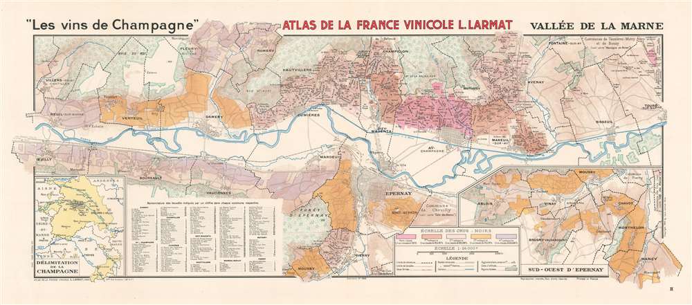
'Les vins de Champagne' Vallée de la Marne.
1944 (dated) 16.5 x 39 in (41.91 x 99.06 cm) 1 : 26000
1944 (dated) 16.5 x 39 in (41.91 x 99.06 cm) 1 : 26000
Description
This is a 1944 Louis Larmat map of the Marne Valley (Vallée de la Marne) in the Champagne region of France. Depicting from Oeuilly to Tours-sur-Marne and from Romery and Fleury-la-Riviere to Moussy, the map focuses on the grape producers, the vignobles. Black dashed lines create the boundaries of the region's villages, which include Epernay, Champillon, Aÿ, and Avenay. Nearly two hundred lieuxdits (which roughly translates to hamlet and embodies the idea of a place name that only locals would know) are numerically identified throughout the region and correspond with an index on the bottom left. An inset on the lower right illustrates the region southwest of Epernay. On the lower left a second inset situates the present map within the Champagne region. The various colors represent the ratings of the échelle des crus: noirs, the way of ranking the quality of grape grown in a given location. These ratings are based on a percentage scale out of 100, and when the system was instituted, each village, not each specific winery, was given a percentage out of 100. Here, five colors are used to mark the different percentages. Grand crus grapes, deemed to be the highest-quality grapes which received a 100% rating, were paid 100% of that a given year's set price. Thus the percentage assigned to the village determined the percentage any given grower would receive for their grapes.
The échelle des crus
The échelle des crus came into existence after tensions arose between the vine-growers and the Champagne houses. The Champagne houses began importing grapes from other regions in France in an effort to cut costs and generate greater profit. This move angered the local vine-growers, who believed that grapes grown outside Champagne could not produce true Champagne. The growers petitioned the French government, which passed a law requiring that 51% of the grapes used to make Champagne had to come from the Champagne region. This resulted in the Champagne houses hiring agents, who more often than not intimidated growers or demanded bribes so they could buy the grapes at the lowest possible price. These tactics, combined with a string of poor harvests caused by bad weather and the devastation caused by the phylloxera epidemic, led to the Champagne riots of 1901 and 1911. In turn, the riots led to the échelle des crus, an agreement between the producers and the growers. As stated above, the rating system starts with the Grand crus villages (of which there are current seventeen which occupy less than 9% of the land in Champagne) at 100% and descends from there. The ratings go as low as 60% on the present map, but in practice, the ratings do not go below 80%.Publication History and Census
This map was created by Lous Larmat and published in 1944 in Volume IV of his Atlas de la France Vinicole dedicated to 'Les vins de Champagne.' The separate map is not cataloged in OCLC. However, the atlas appears in ten institutional collections worldwide.Cartographer
Louis Larmat (19xx - xxxx) was a French publisher and cartographer active during the mid-20th century. Larmat published the world's first national wine atlas, his Atlas de la France Vinicole between 1941 and 1947. Divided into six volumes, each volume focused on a specific wine producing region. Volume one detailed wines from Bordeaux and subsequent volumes focused on Bourgogne, les côtes du Rhône, Champagne, les coteaux de la Loire, and the eaux-de-vie de France and cognac. Subsequent editions were published in 1949 and 1953, many of which were updated. It also appears that Larmat intended to produce a series of road maps meant for self-guided wine tours, the 'route des grand crus.' Only one of these is known to exist and focuses on the Bordeaux region. This map was not simply taken from the atlas focusing on Bordeaux. It was a new creation and includes the main roads and vignettes of several of the chateaux. Very little is known about Larmat's life and career apart from the Atlas de la France Vinicole. The Bibliothèque nationale de France notes that he was a publisher in Paris (éditeur Parisien) and provides two Parisian addresses. His earliest accredited publication dates to 1924 and was published in Nice, which suggests the Larmat may have begun his career there. He also published three separate maps later in his career: the general 'Carte de la France Vinicole' by Marcel Azema in 1945, the 'Carte du Vignoble Alsacien' by Robert Louis in 1949, and 'L'Algérie Vinicole' by Georges Lafosse in 1954. More by this mapmaker...
Source
Larmat, L. Atlas de la France Vinicole. Tome IV. Les Vins de Champagne (Paris: Larmat) 1944.
Condition
Very good. Exhibits light wear along original fold lines. Blank on verso.