This item has been sold, but you can get on the Waitlist to be notified if another example becomes available, or purchase a digital scan.
1866 Mitchell Map of the Western Hemisphere
WesternHemi-mitchell-1866$37.50

Title
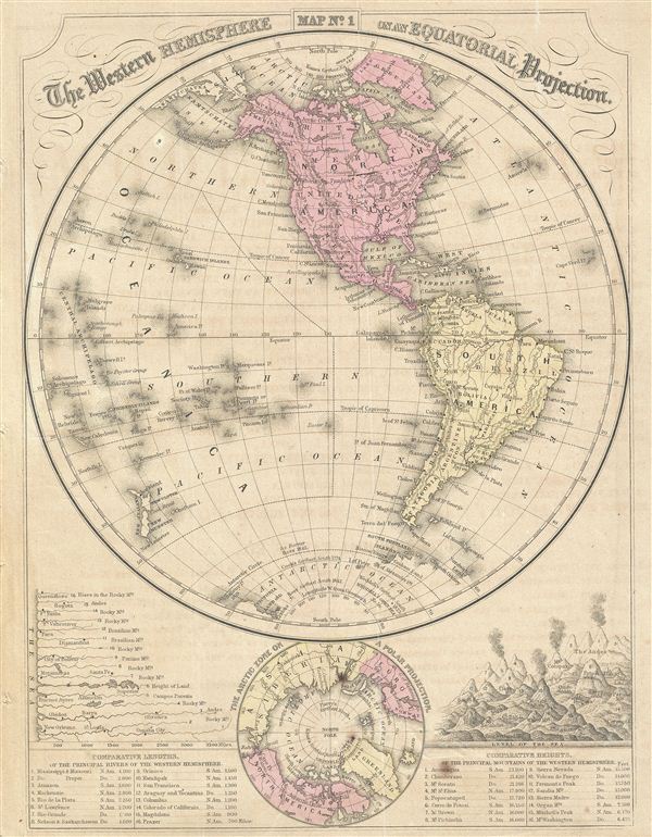
The Western Hemisphere on an Equatorial Projection.
1866 (undated) 11.5 x 9 in (29.21 x 22.86 cm)
1866 (undated) 11.5 x 9 in (29.21 x 22.86 cm)
Description
This is a fine example of the 1866 Mitchell map of the Western Hemisphere or the Americas. Offering a fascinating snapshot of the world during a period of rapid globalization and discovery, this map of the Western Hemisphere includes North America, South America and most of Polynesia. Antarctica is only tenuously denoted, reflecting the primitive state of exploration in the region. The eastern Hemisphere map includes Africa, Asia, europe and Australia. Both maps identify various cities, towns, rivers, lakes, mountain passes and an assortment of additional topographical details. Smaller maps near the bottom of each map feature the Arctic and the Antarctic Zones on a Polar Projection. The bottom left and right quadrant also features the comparative lengths of the principal rivers and the comparative heights of the principal mountains in each hemisphere respectively. The map is printed on both sides with verso featuring the map of the eastern Hemisphere. This map is part of Mitchell's school atlas published in 1866.
Cartographer
Samuel Augustus Mitchell (March 20, 1792 - December 20, 1868) began his map publishing career in the early 1830s. Mitchell was born in Bristol, Connecticut. He relocated to Philadelphia in 1821. Having worked as a school teacher and a geographical writer, Mitchell was frustrated with the low quality and inaccuracy of school texts of the period. His first maps were an attempt to rectify this problem. In the next 20 years Mitchell would become the most prominent American map publisher of the mid-19th century. Mitchell worked with prominent engravers J. H. Young, H. S. Tanner, and H. N. Burroughs before attaining the full copyright on his maps in 1847. In 1849 Mitchell either partnered with or sold his plates to Thomas, Cowperthwait and Company who continued to publish the Mitchell's Universal Atlas. By about 1856 most of the Mitchell plates and copyrights were acquired by Charles Desilver who continued to publish the maps, many with modified borders and color schemes, until Mitchell's son, Samuel Augustus Mitchell Junior, entered the picture. In 1859, S.A. Mitchell Jr. purchased most of the plates back from Desilver and introduced his own floral motif border. From 1860 on, he published his own editions of the New General Atlas. The younger Mitchell became as prominent as his father, publishing maps and atlases until 1887, when most of the copyrights were again sold and the Mitchell firm closed its doors for the final time. More by this mapmaker...
Condition
Very good. Verso contains map of the Eastern Hemisphere. Minor foxing.