
This item below is out of stock, but another example (left) is available. To view the available item, click "Details."
Details
1903 Scarborough Company Map of Western United States w/Philippine Islands
$500.00
1903 Scarborough Company Map of Western United States w/Philippine Islands
WesternUnitedStates-scarborough-1903$200.00

Title
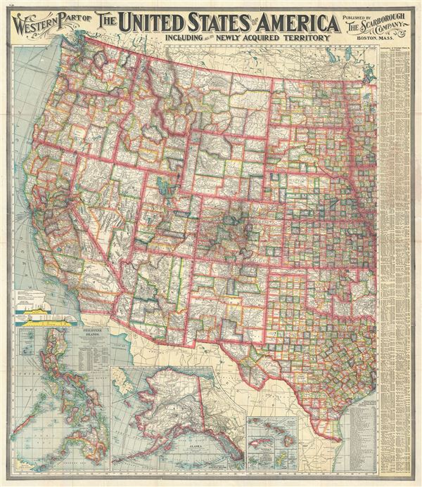
Western Part of The United States of America including all the Newly Acquired Territory.
1903 (undated) 41 x 35 in (104.14 x 88.9 cm) 1 : 3294720
1903 (undated) 41 x 35 in (104.14 x 88.9 cm) 1 : 3294720
Description
This is a large and beautifully detailed 1903 map of the western part of the United States by the Scarborough Company. This pocket map covers the United States westward from North Dakota, South Dakota, Nebraska, Kansas, Oklahoma and Texas and includes parts of Minnesota, Iowa and Missouri. This incredibly detailed map notes countless towns, villages and cities throughout along with individually color coded counties in every state. Rivers, railroads, shipping lines, lakes, mountains and a host of additional topographical features are also noted.
The map is particularly interesting in its illustration of the newly acquired territories of the United States. Three insets of the Philippine Islands, Alaska with the Aleutian Islands and the Hawaiian Islands are included in the lower right quadrant of the map. As a result of the Spanish-American War of 1898, Spain would be forced to cede the Philippine Islands, Puerto Rico and Guam to the United States. The Philippines remained an unincorporated territory of the United States until its independence was formally recognized by the United States in 1946. The United States purchased the 'Department of Alaska' from the Russians in 1867, and organized as a district from 1884 to 1912, when it would be called the Alaska Territory. It would eventually be admitted to the Union as a state in 1959.
An index of the principal places in the United States is features along the right border of the map. The bottom right quadrant lists the principal railroads systems of the United States, showing mileage of each system. Two profiles of sections along the Panama Canal and the Nicaragua Canal are also included. While work on the Panama Canal would begin in 1880 and be completed in 1914, the proposed Nicaragua canal to this date remains to be built, having been superseded by the Panama Canal.
This map was published by the Scarborough Company, Boston, MA.
Condition
Very good. Minor wear along original fold lines. Minor creasing along left index. Slight toning along right index, where map was attached to binder. Professionally flattened and backed with archival tissue.