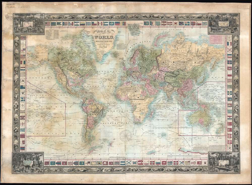
This is a rare 1845 Edward Hooker Ensign map of the world on Mercator's projection depicting both the Republic of Texas and the Oregon border dispute between Canada and the United States. A visually striking and incredibly detailed piece, countries throughout the world are labeled, along with innumerable cities and towns. Myriad coastal locations are identified as well. The courses of the world's most important explorers, including Christopher Columbus, Captain James Cook, Vancouver, and La Perouse are illustrated and labeled, many of the courses also provide several dates along the route. An inset of sorts details the Southern Pacific Ocean, labeling numerous islands and tracing the voyages of Cook and Vancouver in detail. The Mountains of the Moon, an apocryphal chain of mountains in Africa, are illustrated almost completely across the center of the continent, with the vast majority of the African interior marked simply as 'unexplored'. The whole is surrounded by two different borders.
The Border
The border closest to the map is comprised of illustrations of flags of the world, including the flag of the Republic of Texas, the United States, and Great Britain. The flags of individual German duchies and principalities are also illustrated, as are those of North African countries, previously known for their acts of piracy. The outer border consists of four separate illustrations in the corners, each highlighting the flora, fauna, and human civilizations of a given continent. The four featured continents are the Americas, Europe, Asia, and Africa, with vignettes of sea shells separating the four corners.Republic of Texas
The Republic of Texas was a short-lived nation established in March of 1836 when it ceded from Mexico. Following the independence of Mexico from Spain, the American Stephen Fuller Austin lead a group of 300 Empresarios to settle Texas, near Austin, where they received a grant from the Mexican government. As more Americans moved to Texas, resentment and strife began to build between the American settlers and Mexican authorities. This and other factors ultimately led to the Texan Revolution in 1835 and the declaration of Texan independence in 1836. Texas remained an independent republic until it joined the United States 10 years later in 1846.Texas Borders
The borders of the Republic of Texas were in dispute from the earliest days of the Texan Revolution. The Republic-claimed borders followed the Treaties of Velasco between the newly created Texas Republic and Mexican leader, Antonio López de Santa Anna. The treaties established an eastern boundary following the 1819 Adams-Onís Treaty between the United States and Spain, which established the Sabine River as the eastern boundary of Spanish Texas and western boundary of the Missouri Territory. The Republic's southern and western boundary with Mexico was more nuanced. Texas claimed the Rio Grande del Norte as its western and southernmost border, while Mexico argued for a boundary much further east at the Nueces River. When Texas was annexed into the United States, the agreement followed the Republic claimed boundary, thus absorbing Mexican claimed territory as far west as Santa Fe. This escalated already existing tensions between the United States, the former Republic of Texas, and Mexico, ultimately triggering for the Mexican-American War (1846 -1848). 54-40 or Fight! American Claims to British Columbia
Following the transcontinental crossing of North America by the British Northwest Company sponsored explorer Alexander MacKenzie (1792 – 1793), and the American expedition of Lewis and Clark up the Missouri to the mouth of the Columbia River (1804 – 1806), it became apparent that control of the fur and resource rich Pacific Northwest would bring great wealth and power to whoever could assert sovereignty. The American tycoon John Jacob Astor, with the permission of President Thomas Jefferson, was the first to attempt a permeant trading colony in the region, founding Astoria on the Columbia river in 1811. This quickly let to a confrontation with the established British-Canadian Northwest Company over this valuable territory. Americans in the 1820s through the 1840s argued that most of the Pacific Northwest should be part of the United States as a legacy of the 1803 Louisiana Purchase. England, on the other hand, argued for residual claims to the region derived from the MacKenzie Expedition and its fur trading empires: The Northwest Company and the Hudson Bay Company. The Oregon Dispute, as it came to be known, became an important in geopolitical issue between the British Empire and the United States, especially after the War of 1812. Americans adopted the slogan '54-40 or Fight!' until the Oregon Question was finally resolved roughly along the current border-line by the 1846 Oregon Treaty.Publication History and Census
This map was created and published by T and E.H. Ensign in 1845. We gave been unable to locate any institutional examples but it rarely appears on the private market.
CartographerS
Edward Hooker Ensign (August 18, 1818 - July 10, 1871) was an American map and print publisher based in New York during the middle part of the 19th century. Edward was born in West Hartland, Connecticut. Little is known of Ensign's training but he may have inherited his business from his father, Timothy Ensign (1795 - 1859), who was a map publisher active in New York. Ensign seems to have had a flair for partnerships and variously published with Humphrey Phelps (1799 - 1875), Horace Thayer, Thomas C. Fanning (1805 - 1873) and Erastus C. Bridgman (1817 - 1870), among others. His various imprints include 'Phelps and Ensign' (1841-1844), 'T. and E. H. Ensign' (1844-1848), 'Ensign and Thayer' (1849), 'Ensign, Thayer, and Company' (1850-1851), 'Horace Thayer and Company' (1852), and 'Ensign, Bridgman and Fanning' (1854-1863). It appears that father and son worked together for some time as well, publishing as either 'T. and E. H. Ensign' or 'Ensigns'. At least some of these companies maintained offices in both Buffalo and New York City. More by this mapmaker...
John M. Atwood (1817 - October 12, 1884) was an American engraver based in Philadelphia and New York City during the middle part of the 19th century. Atwood was born in Georgetown, near Washington D.C. Little is known of Atwood's life but most of his work was completed in conjunction with the publishing firms of Horace Thayer and J. H. Colton. A review of Atwood's work suggests that he was a highly accomplished, stylistically distinct, and detail oriented engraver. Colton seems to have turned to Atwood to engrave some of his most important as well as decorative maps. His most influential map is most likely the 1856 De Cordova pocket map of Texas, however, he also engraved the Colton's well known and highly decorative Thirty Three Miles Around New York and Colton's important 1849 Map of the United States. Learn More...
Very good. Full professional restoration. Mounted on linen. Blank on verso.