This item has been sold, but you can get on the Waitlist to be notified if another example becomes available, or purchase a digital scan.
1901 Rand McNally Pocket Map of Wyoming
Wyoming-mcnally-1901$100.00

Title
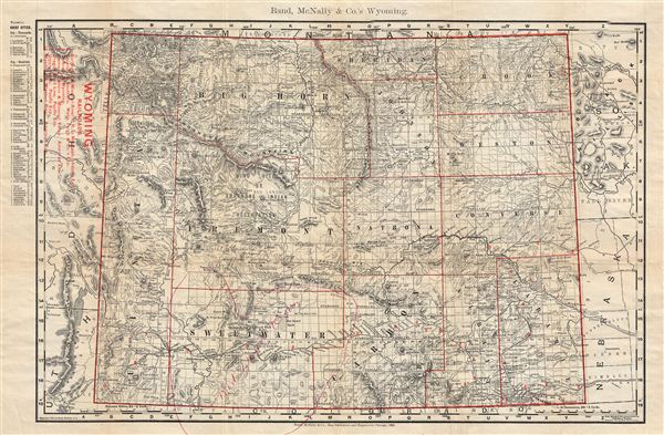
Pocket Map and Shippers' Guide of Wyoming.
1901 (dated) 13.5 x 19.5 in (34.29 x 49.53 cm)
1901 (dated) 13.5 x 19.5 in (34.29 x 49.53 cm)
Description
An uncommon 1901 map of Wyoming by Rand, McNally, and Company. Rand McNally first issued this map in 1895. The map covers the entire state of Wyoming identifying counties, rivers, topography and railroads. An index of major cities appears in the upper left quadrant. Someone has added a charming heart shaped manuscript annotation over Sweetwater County identified the ‘Red Desert Region.' Yellowstone Park is included in full. The map is accompanied by its original binder containing a short index as well as advertising.
Cartographer
Rand, McNally and Co. (fl. 1856 - present) is an American publisher of maps, atlases and globes. The company was founded in 1856 when William H. Rand, a native of Quincy, Massachusetts, opened a print shop in Chicago. Rand hired the recent Irish immigrant Andrew McNally to assist in the shop giving him a wage of 9 USD per week. The duo landed several important contracts, including the Tribune's (later renamed the Chicago Tribune) printing operation. In 1872, Rand McNally produced its first map, a railroad guide, using a new cost effective printing technique known as wax process engraving. As Chicago developed as a railway hub, the Rand firm, now incorporated as Rand McNally, began producing a wide array of railroad maps and guides. Over time, the firm expanded into atlases, globes, educational material, and general literature. By embracing the wax engraving process, Rand McNally was able to dominate the map and atlas market, pushing more traditional American lithographic publishers like Colton, Johnson, and Mitchell out of business. Eventually Rand McNally opened an annex office in New York City headed by Caleb S. Hammond, whose name is today synonymous with maps and atlases, and who later started his own map company, C. S. Hammond & Co. Both firms remain in business. More by this mapmaker...
Condition
Very good. Light toning on original fold lines. Heart shaped manuscript annotation identifying the 'Red Desert' over Sweetwater County. Accompanied by original index and binder.
References
Rumsey 3381.002 (1909 edition).