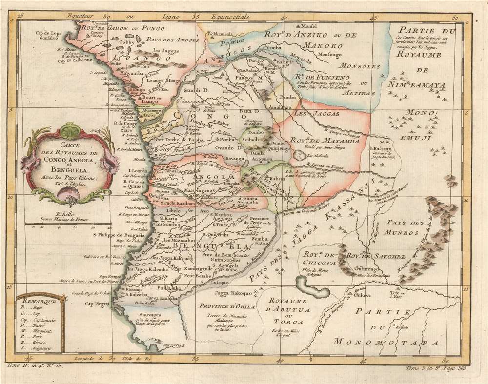
This is a 1780 Jacques-Nicolas Bellin map of west-central Africa. Focusing on the kingdoms surrounding the Congo River, Bellin provides a snapshot of Portuguese colonial dominance in the region. Numerous towns and villages are labeled, some of them Portuguese, some of them African. Short comments provide some information where it was available, such as, concerning the Royaume de Dongo, 'destroyed by the Portuguese.' Or, just below Benguela, where savages or sauvages apparently live, 'it is said that language is not used here.'
African Kingdoms
Many of these kingdoms were important states in early-modern Africa. The Kingdom of Ndongo (also known as Dongo or Angola), existed as early as the 1530s, probably earlier. It was then destroyed, as Bellin relates, by colonial Portuguese who wanted to control parts of modern-day Angola and build forts and bring settlers. The Kingdom of Matamba was another powerful early-modern African kingdom that resisted Portuguese advances for several years before its kingdom was invaded in 1744, divided in two, and then eventually annexed by Portuguese Angola.Portuguese Colonialism in Angola
Portuguese Angola was founded in 1575 with the settlement of Luanda. The Portuguese founded Benguela in 1617. Thus, this map captures a moment in the history of European colonialism in Africa. It highlights Portugal's efforts to consolidate rule in Angola after their conquest of the Kingdom of Ndongo and before the complete subjugation of the Kingdom of Matamba.Publication History and Census
Originally created for of Abbé Prévost's Histoire Générale des Voyages by Jacques-Nicolas Bellin, this map was published by Jean François de La Harpe's in his Abrégé de l'Histoire Générale des Voyages in 1780. Two examples of the 1780 edition of this map are cataloged in OCLC and are part of the institutional collections at Universitätsbibliothek München in Munich and Bayerische Staatsbibliothek, also in Munich. The works by Prévost and de la Harpe are well represented institutionally.
Cartographer
Jacques-Nicolas Bellin (1703 - March 21, 1772) was one of the most important cartographers of the 18th century. With a career spanning some 50 years, Bellin is best understood as geographe de cabinet and transitional mapmaker spanning the gap between 18th and early-19th century cartographic styles. His long career as Hydrographer and Ingénieur Hydrographe at the French Dépôt des cartes et plans de la Marine resulted in hundreds of high quality nautical charts of practically everywhere in the world. A true child of the Enlightenment Era, Bellin's work focuses on function and accuracy tending in the process to be less decorative than the earlier 17th and 18th century cartographic work. Unlike many of his contemporaries, Bellin was always careful to cite his references and his scholarly corpus consists of over 1400 articles on geography prepared for Diderot's Encyclopedie. Bellin, despite his extraordinary success, may not have enjoyed his work, which is described as "long, unpleasant, and hard." In addition to numerous maps and charts published during his lifetime, many of Bellin's maps were updated (or not) and published posthumously. He was succeeded as Ingénieur Hydrographe by his student, also a prolific and influential cartographer, Rigobert Bonne. More by this mapmaker...
Source
De la Harpe, Abrégé de l'histoire générale des voyages. (Paris) 1780.
Very good. Exhibits light offsetting.
OCLC 635220101 ; 231963690.