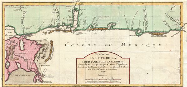
The extremely scarce first edition first state of Bellin's important 1744 map of the Gulf Coast from New Orleans past Mobile Bay, as far east as Apalachicola Bay and the St. Marks River. Though still quite speculative, Bellin's rendition of this little known coastline was, at the time, among the best available. The cartographer charts the course of the Mississippi River with some care nothing both the 'Detour des Piaquemines' and the English Turn or 'Detour a L'Anglois.' Most of the delta is represented a ffertile grassland, but some forested regions suitable for European settlement are noted near the Abandoned French Fort de la Boulaye. Following the map eastward along the coastline Bellin offers details as they were available. The site of various battles and massacres are identified as are American Indian villages, mission stations, fortifications, and European entrapots such as Biloxi, Mobile, St. Marc, and indeed New Orleans itself. A Spanish settlement is noted near the Apalachicola River and St. Joseph Bay (Baye St. Joseph) a clear reminder that much of this territory, though claimed by various European powers and American Indian nations, remained very much up for grabs. Mobile Bay, situated near the center of the map, is vaguely formed with Bon Secour Bay being vastly under represented. In the far northwest corner of the map the Natchez Trace or Natchez Road. This network of linked gamed trails is one of the world's oldest roadways, well used centuries before the arrival of Europeans. At the time Bellin drew this map the Natchez Trace was a major trade artery for Choctaw, Natchez, and Chicasaw.
Bellin originally prepared this map to illustrate Pierre François Xavier de Charlevoix's Histoire et description generale de la Nouvelle France. It was most likely engraved by Guillaume Dheulland. Charlevoix's history and this map in particular thus proved exceptionally influential as one of the most comprehensive works on North America predating the French and Indian War. Copies of the Histoire et description generale were to be found in the libraries of many 18th century luminaries, including Voltaire, Franklin, and Jefferson. Jefferson especially admired Charlevoix work, calling it 'a particularly useful species of reading' and no doubt influenced his decision to pursue the historic 1802 Louisiana Purchase, possibly the most significant event in the post-colonial history of North America.
Cartographer
Jacques-Nicolas Bellin (1703 - March 21, 1772) was one of the most important cartographers of the 18th century. With a career spanning some 50 years, Bellin is best understood as geographe de cabinet and transitional mapmaker spanning the gap between 18th and early-19th century cartographic styles. His long career as Hydrographer and Ingénieur Hydrographe at the French Dépôt des cartes et plans de la Marine resulted in hundreds of high quality nautical charts of practically everywhere in the world. A true child of the Enlightenment Era, Bellin's work focuses on function and accuracy tending in the process to be less decorative than the earlier 17th and 18th century cartographic work. Unlike many of his contemporaries, Bellin was always careful to cite his references and his scholarly corpus consists of over 1400 articles on geography prepared for Diderot's Encyclopedie. Bellin, despite his extraordinary success, may not have enjoyed his work, which is described as "long, unpleasant, and hard." In addition to numerous maps and charts published during his lifetime, many of Bellin's maps were updated (or not) and published posthumously. He was succeeded as Ingénieur Hydrographe by his student, also a prolific and influential cartographer, Rigobert Bonne. More by this mapmaker...
Source
Charlevoix, Pierre François Xavier de, Histoire et description generale de la Nouvelle France, avec le journal historique d'un voyage fait par ordre du roi dans l'Amérique septentrionnale, (Paris: Chez Rollin) 1744.
Very good. Lower margin narrow. Right margin partially trimmed - see image. Original fold lines exhibit minor wear. Blank on verso.
Boston Public Library, Leventhal Collection, G4012.C6 1744 .B4. Tooley, R. V., Map Collectors Circle, 'Printed Maps of America VI', Vol 96, #719.