This item has been sold, but you can get on the Waitlist to be notified if another example becomes available, or purchase a digital scan.
1780 Bonne Map of Northern India
IndiaNorth-bonne-1780$75.00

Title
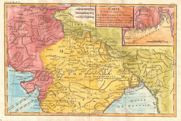
Carte de la Partie Superieure de L'Inde en Deca du Gange, Comprise entre la Cote du Concan et celle d'Orixa avec l'Empire du Mogol, le Bengale, Le Re. d'Atham, partie du ceux d'Ave et de Pegu.
1780 (undated) 10.5 x 15 in (26.67 x 38.1 cm)
1780 (undated) 10.5 x 15 in (26.67 x 38.1 cm)
Description
A beautiful example of Rigobert Bonne's decorative map of northern India. Covers the northern region of subcontinent from Dabul in the south, to its border with Tibet in the north. Also shows what is modern day Pakistan and Afghanistan in the West, and China in the east. To the east is Bangladesh. Includes a detailed inset showing the area around the mouth of the Ganges with Calcutta in the center. Names a number of important Indian cities and river systems. Rhumb lines appear in nautical zones. Arrows in the lower left and lower right show the direction of prevailing winds during the dry season and the monsoon season. Drawn by R. Bonne c. 1780's.
Cartographer
Rigobert Bonne (October 6, 1727 - September 2, 1794) was one of the most important French cartographers of the late 18th century. Bonne was born in Ardennes à Raucourt, France. He taught himself mathematics and by eighteen was a working engineer. During the War of the Austrian Succession (1740 - 1748) he served as a military engineer at Berg-op-Zoom. It the subsequent years Bonne became one of the most respected masters of mathematics, physics, and geography in Paris. In 1773, Bonne succeeded Jacques-Nicolas Bellin as Royal Cartographer to France in the office of the Hydrographer at the Depôt de la Marine. Working in his official capacity, Bonne compiled some of the most detailed and accurate maps of the period - most on an equal-area projection known erroneously as the 'Bonne Projection.' Bonne's work represents an important step in the evolution of the cartographic ideology away from the decorative work of the 17th and early 18th century towards a more scientific and practical aesthetic. While mostly focusing on coastal regions, the work of Bonne is highly regarded for its detail, historical importance, and overall aesthetic appeal. Bonne died of edema in 1794, but his son Charles-Marie Rigobert Bonne continued to publish his work well after his death. More by this mapmaker...
Source
Bonne, R., Atlas de toutes les parties connues du globe terrestre, dressé pour l'Histoire philosophique et politique des établissemens et du commerce des Européens dans les deux Indes, 1780.
Condition
Good. Contemporary color. Original centerfold. Blank on verso.
References
Yale University, Beinecke Rare Book and Manuscript Library, 1974 +227.