This item has been sold, but you can get on the Waitlist to be notified if another example becomes available, or purchase a digital scan.
1735 Bellin Map of the Empire of Japan
Japan-bellin-1735$400.00

Title
Carte de l'empire du Japon, dressée sur les auteurs japonois, sur les mémoires des portugais et des hollandois et en particulier sur ceux des RRPP. de la comp. de Jesus.
1735 (dated) 16.5 x 21.5 in (41.91 x 54.61 cm) 1 : 3300000
1735 (dated) 16.5 x 21.5 in (41.91 x 54.61 cm) 1 : 3300000
Description
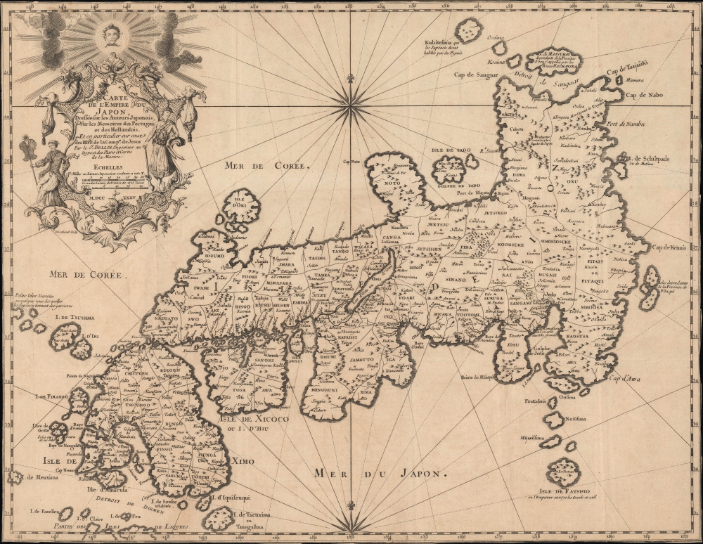
This is Jacques-Nicolas Bellin's 1735 / 1754 map of Japan, published in Pierre François Xavier de Charlevoix's Histoire et description générale du Japon, an influential work throughout the 18th century.
The map includes several inaccuracies. Shikoku Island (here identified as I. Xixoco) appears to be almost square with a deep inlet on its northern side, while Kyushu (Insel Ximo) is slanted to the east. On the island of Honshu (Insel Nippon), Aomori Prefecture is foreshortened while the Oki Islands appear exaggerated. Shimane prefecture and the Noto Peninsula are also distorted. The island of Hokkaido is referred to as the 'I. de Matsumay,' after the ruling Matsumae clan, which ruled a domain (han) in southern Hokkaido. The Isle de Fatsisio at bottom-right is Hachijō-jima, where political opponents of the shogun (not the emperor) and other criminals were exiled.
Nonetheless, outside influences continued to come into Japan, primarily through Nagasaki, where Dutch and Chinese traders were allowed to reside on offshore islands. Moreover, foreign vessels landed on Japan's shores (and were usually attacked) with increasing frequency in the 18th and early 19th-century. Several visitors came to Nagasaki from other countries over the years, so that Japanese intellectuals had an awareness of changes taking place in maritime technology, cartography, hydrography, and other fields. Still, this steady drip of outside information was not enough for the Tokugawa to fully realize the rapidly emerging threat of foreign invasion, which only became clear with the arrival of American 'black ships' in 1853.
The present example appears to be the second state of the map, dated to 1754, which lacks Kamchatka and additional islands north of Hokkaido. In either state, the map is only independently cataloged among the holdings of the Bibliothèque nationale de France, the University of California Berkeley, and the British Library, while Charlevoix's entire work is more widespread.
A Closer Look
Centered on the Bay of Osaka, coverage ranges from the northern islands of Japan (Ezo) to the Ryukyu Islands, which were vassals of Satsuma (Saxuma) Domain. Various towns, harbors, bays, provinces, mountains, and daimyo are noted, although many are speculative.The map includes several inaccuracies. Shikoku Island (here identified as I. Xixoco) appears to be almost square with a deep inlet on its northern side, while Kyushu (Insel Ximo) is slanted to the east. On the island of Honshu (Insel Nippon), Aomori Prefecture is foreshortened while the Oki Islands appear exaggerated. Shimane prefecture and the Noto Peninsula are also distorted. The island of Hokkaido is referred to as the 'I. de Matsumay,' after the ruling Matsumae clan, which ruled a domain (han) in southern Hokkaido. The Isle de Fatsisio at bottom-right is Hachijō-jima, where political opponents of the shogun (not the emperor) and other criminals were exiled.
Sources
Bellin attributed this map to Jesuit and Portuguese sources, but upon deeper analysis it is derived more closely from the work of the German traveler and naturalist Engelbert Kaempfer (1651 - 1716). Having spent 2 years in Japan, Kaempfer was considered one of Europe's leading Japanologists. Charlevoix likely did not credit Kaempfer due to his distaste for Protestants and his deep connections to the Jesuit order.'Sea of Korea'
The sea between Japan and Korea, whose name, either the 'Sea of Korea', 'East Sea', or the 'Sea of Japan,' is here identified in favor of Korea (Mer de Corée). Historically, Korea has used the term 'East Sea' since 59 B.C., and many books published before the Japanese annexed Korea make references to the 'East Sea' or 'Sea of Korea'. Over time, neighboring and western countries have identified Korea's East Sea using various terms. The St. Petersburg Academy of Sciences referred to the East Sea as 'Koreiskoe Mope' or 'Sea of Korea' in their 1745 map of Asia. Other seventeenth and 18th century Russian maps alternate between 'Sea of Korea' and 'Eastern Ocean'. The 18th century Russian and French explorers Adam Johan von Krusenstern and La Perouse called it the 'Sea of Japan', a term that became popular worldwide. Nonetheless, the last official map published by the Russians name the East Sea the 'Sea of Korea'. The name is currently still a matter of historical and political dispute.The Tokugawa and the Outside World
In the second half of the 16th century, Japan underwent a process of unification that was strongly influenced by exchanges with the outside world, including by way of Japanese settlers in Southeast Asia. After completing the process of unification in 1600, the Tokugawa Shogunate were concerned about the problems that these exchanges presented (namely Christianity and guns for wayward daimyo) and nominally closed off Japan from the outside world on pain of death (known as the sakoku or 'locked country' policy).Nonetheless, outside influences continued to come into Japan, primarily through Nagasaki, where Dutch and Chinese traders were allowed to reside on offshore islands. Moreover, foreign vessels landed on Japan's shores (and were usually attacked) with increasing frequency in the 18th and early 19th-century. Several visitors came to Nagasaki from other countries over the years, so that Japanese intellectuals had an awareness of changes taking place in maritime technology, cartography, hydrography, and other fields. Still, this steady drip of outside information was not enough for the Tokugawa to fully realize the rapidly emerging threat of foreign invasion, which only became clear with the arrival of American 'black ships' in 1853.
Publication History and Census
This map was drawn by Jacques-Nicolas Bellin and engraved by Guillaume Dheulland in 1735 for inclusion in Pierre François Xavier de Charlevoix's Histoire et description générale du Japon. Both Bellin and Charlevoix were influenced by Engelbert Kaempfer's Historia Imperii Japonica, published in London in 1727. Bellin's map of Japan was issued throughout the 18th century in various formats and sizes, including in Abbé Antoine François Prévost's Histoire générale des Voyages.The present example appears to be the second state of the map, dated to 1754, which lacks Kamchatka and additional islands north of Hokkaido. In either state, the map is only independently cataloged among the holdings of the Bibliothèque nationale de France, the University of California Berkeley, and the British Library, while Charlevoix's entire work is more widespread.
Cartographer
Jacques-Nicolas Bellin (1703 - March 21, 1772) was one of the most important cartographers of the 18th century. With a career spanning some 50 years, Bellin is best understood as geographe de cabinet and transitional mapmaker spanning the gap between 18th and early-19th century cartographic styles. His long career as Hydrographer and Ingénieur Hydrographe at the French Dépôt des cartes et plans de la Marine resulted in hundreds of high quality nautical charts of practically everywhere in the world. A true child of the Enlightenment Era, Bellin's work focuses on function and accuracy tending in the process to be less decorative than the earlier 17th and 18th century cartographic work. Unlike many of his contemporaries, Bellin was always careful to cite his references and his scholarly corpus consists of over 1400 articles on geography prepared for Diderot's Encyclopedie. Bellin, despite his extraordinary success, may not have enjoyed his work, which is described as "long, unpleasant, and hard." In addition to numerous maps and charts published during his lifetime, many of Bellin's maps were updated (or not) and published posthumously. He was succeeded as Ingénieur Hydrographe by his student, also a prolific and influential cartographer, Rigobert Bonne. More by this mapmaker...
Source
Charlevoix, F. X., Histoire et description générale du Japon (Paris: Julien-Michel Gandouin, Jean-Baptiste Lamesle, Pierre-François Giffart, Rollin fils and Nyon fils) 1736.
Condition
Very good. Creasing along fold lines. Discoloration at top-left near edge. Margin trimmed to neatline.
References
OCLC 494169229, 15999173, 557812030.