
This item below is out of stock, but another example (left) is available. To view the available item, click "Details."
Details
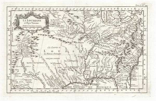
1757 Bellin Map of the United States
1757 (undated) $650.00
1764 Bellin Map of the French Louisiana
LaLouisiane-bellin-1764$225.00

Title
La Louisiane et Pays Voisins.
1764 (undated) 9 x 14.25 in (22.86 x 36.195 cm) 1 : 10000000
1764 (undated) 9 x 14.25 in (22.86 x 36.195 cm) 1 : 10000000
Description
This is an important 1764 map of French Louisiana by the French cartographer Jacques-Nicholas Bellin. Centered on the Mississippi Valley, Bellin's map covers from the Riviere du Nord (Rio Grande) eastward to Lake Ontario and from Lake Huron to the Gulf of Mexico and Florida. This map is extremely rich in detail offering and naming countless American Indian settlements and villages. Bellin offers a wealth of new material throughout, marking this map as a unique and meticulously researched production.
Like the 1757 Bellin map which utilizes the same cartography, this map is significant on many levels. The 1757 map presents, from a French perspective, the territorial alignments and claims of North America at the beginning of the French and Indian War. This map, however, illustrates what France lost during the war. In 1763, in the treaty ending hostilities between Britain and France in North America, Britain gave France the choice of giving up its North American possessions east of the Mississippi River or the Caribbean islands of Martinique and Guadeloupe. The French chose the former, believing the income from the sugar cane grown on the islands to be much more valuable (and more easily defended) than the fur trade and its vast land holdings in North America. The word 'Louisiane' at center immediately defines the map's focus. French territory extended as far east as the Appalachian Mountains and as far as west the Riviere du Nord (Rio Grande), including all of Texas and parts of modern-day New Mexico - claims associated with La Salle's explorations and colonization of the Gulf Coast in 1685 (these claims, incidentally, led to 19th century U.S. Claims on Texas associated with the Louisiana's Purchase). As this is a French map, detailed identification of hundreds of American Indian nations and settlements throughout the territory, mostly along known river courses, further illustrate France's paternal and comparatively peaceable approach to New World Indian relations, commerce, and colonization.
Most consider the French and Indian War to be a microcosm of the global Seven Years' War. It was, however, notably distinct from the wider Seven Years' War because it began before hostilities commenced in Europe and most of the major battles of the French and Indian War involved parties only loosely aligned with the French or English - most specifically American Indians and lawless frontiersman, who had their own political agenda. The war began with French incursions into western Pennsylvania and other territories claimed simultaneously by French, English, and American Indian forces. Just prior to the war, the French, in the interest of broadening their hold on the lucrative fur trade, established a series of forts, all of which are here noted, along the length of the Mississippi and further east, including Fort Duquesne, Fort de la Presquisle, and Fort Le Beouf. It lasted for nine years, with the French scoring victories in the first few years of the war, while the British won key battles in the war's final years, securing their strong negotiating position which led to the French decision to cede all their territory east of the Mississippi to the British in the treaty ending the war.
This map was drawn by Jacques Nicolas Bellin and published in volume 1 of the Petit Atlas Maritime, Recueil de Cartes et Plans des Quatre Parties du Monde en Cinq Volumes in 1764.
Cartographer
Jacques-Nicolas Bellin (1703 - March 21, 1772) was one of the most important cartographers of the 18th century. With a career spanning some 50 years, Bellin is best understood as geographe de cabinet and transitional mapmaker spanning the gap between 18th and early-19th century cartographic styles. His long career as Hydrographer and Ingénieur Hydrographe at the French Dépôt des cartes et plans de la Marine resulted in hundreds of high quality nautical charts of practically everywhere in the world. A true child of the Enlightenment Era, Bellin's work focuses on function and accuracy tending in the process to be less decorative than the earlier 17th and 18th century cartographic work. Unlike many of his contemporaries, Bellin was always careful to cite his references and his scholarly corpus consists of over 1400 articles on geography prepared for Diderot's Encyclopedie. Bellin, despite his extraordinary success, may not have enjoyed his work, which is described as "long, unpleasant, and hard." In addition to numerous maps and charts published during his lifetime, many of Bellin's maps were updated (or not) and published posthumously. He was succeeded as Ingénieur Hydrographe by his student, also a prolific and influential cartographer, Rigobert Bonne. More by this mapmaker...
Condition
Very good. Even overall toning. Light wear along original centerfold. Blank on verso.
References
OCLC 5407431.