This is S. A. Mitchell's 1850 map of Louisiana and New Orleans.
A Closer Look
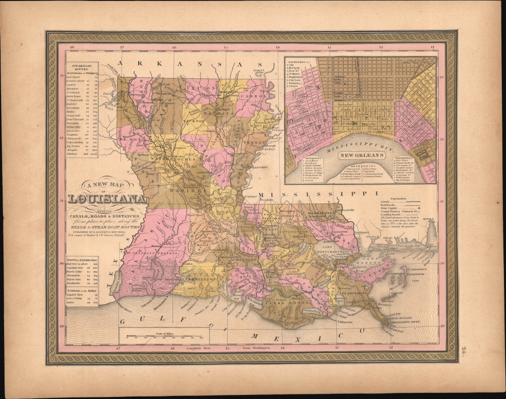
The map depicts the entire state, employing color to distinguish individual parishes. Canals and roads are illustrated, along with distances between major points. The state's only railroad is the 27-mile Clinton and Port Jackson Railroad, which had been operating since 1841 - this railroad gained greater significance after the fall of Baton Rouge during the American Civil War (1861 - 1865). A large inset in the upper right contains a plan of New Orleans illustrating the city grid, districts, municipal buildings, and piers. The whole is surrounded by the green border common to Mitchell maps from the 1850s.Historical Context
In 1850, Louisiana was a mosaic of cultures, a legacy of its colonial history, most of which centered around New Orleans. The state's economy thrived on the fertile lands of the Mississippi River Delta, where sugar cane and cotton plantations abounded. The port of New Orleans, a crucial gateway between the Mississippi Valley, the agrarian South, and international markets, facilitated the export of plantation commodities and other goods, making it one of the wealthiest cities in the nation.Publication History and Census
This map was prepared by S. A. Mitchell for publication by the Philadelphia firm of Thomas, Cowperthwait, and Co. as plate no. 24 in the 1850 edition of Mitchell's New General Atlas. Dated and copyrighted, 'Entered according to act of Congress in the year 1850 by Thomas Cowperthwait and Co. in the Clerk's office of the Eastern District of Pennsylvania'.
CartographerS
Samuel Augustus Mitchell (March 20, 1792 - December 20, 1868) began his map publishing career in the early 1830s. Mitchell was born in Bristol, Connecticut. He relocated to Philadelphia in 1821. Having worked as a school teacher and a geographical writer, Mitchell was frustrated with the low quality and inaccuracy of school texts of the period. His first maps were an attempt to rectify this problem. In the next 20 years Mitchell would become the most prominent American map publisher of the mid-19th century. Mitchell worked with prominent engravers J. H. Young, H. S. Tanner, and H. N. Burroughs before attaining the full copyright on his maps in 1847. In 1849 Mitchell either partnered with or sold his plates to Thomas, Cowperthwait and Company who continued to publish the Mitchell's Universal Atlas. By about 1856 most of the Mitchell plates and copyrights were acquired by Charles Desilver who continued to publish the maps, many with modified borders and color schemes, until Mitchell's son, Samuel Augustus Mitchell Junior, entered the picture. In 1859, S.A. Mitchell Jr. purchased most of the plates back from Desilver and introduced his own floral motif border. From 1860 on, he published his own editions of the New General Atlas. The younger Mitchell became as prominent as his father, publishing maps and atlases until 1887, when most of the copyrights were again sold and the Mitchell firm closed its doors for the final time. More by this mapmaker...
Joseph Baker Cowperthwait (October 15, 1833 - November 26, 1891) was an American book and map publisher. Born in Philadelphia, Cowperthwait became a successful map publisher, taking over the Samuel Augustus Mitchell Sr. (1792 - 1868) maps, atlases, and plates in 1850. His father, Hulings Cowperthwait (1802 -1873), began the publishing business, and was part of a few publishing firms, including Thomas, Cowperthwait, and Company and Cowperthwait, Desilver, and Butler. Cowperthwait, Desilver, and Butler dissolved in 1855 and H. Cowperthwait, Joseph B. Cowperthwait, D. M. Warren, George Pancoast, and Theodore H. Butler together formed H. Cowperthwait and Co. Cowperthwait died on Thanksgiving Day, 1891. Learn More...
Source
Mitchell, S. A., A New Universal Atlas Containing Maps of the various Empires, Kingdoms, States and Republics Of The World, (Philadelphia: Thomas Cowperthwait) 1850.
The New Universal Atlas is one of the great American atlases of the mid-19th century. Samuel Augustus Mitchell first issued the atlas in 1846 when he acquired the map plates and copyright for Tanner's New Universal Atlas from its publisher, Carey and Hart. The first transitional 1846 edition was published jointly with Carey and Hart, but a second edition was published in the same year with the Tanner imprint erased. This edition of the atlas also introduced the signature S. A. Mitchell green and pink color scheme. Most of the maps from the early editions of the atlas were engraved by H. N. Burroughs or C. S. Williams, often bearing their copyright. Burroughs maps also tended to have what map collector David Rumsey refers to as the 'Cary and Hart' borders, which featured a narrow vine motif. These borders were replaced, along with the Burroughs imprint, with the more traditional Mitchell strap work border used in the atlases until 1856. Mitchell published editions until late in 1850, when he sold the rights to Thomas, Cowperthwait and Company of Philadelphia. Under Cowperthwait, the atlases continued to be published and bear the Mitchell name until 1856, when it the plates were again sold, this time to Charles Desilver. Desilver reworked the plates with new border art and a revised color scheme in the style of J. H. Colton. Desilver issued editions from 1857 to 1860, when the atlas was phased out in favor of Samuel Augustus Mitchell Jr.'s New General Atlas.
Very good. Overall age toning. Minor spotting.
Rumsey 0545.028 (1849 edition). Phillips (Atlases) 6913.