
This item below is out of stock, but another example (left) is available. To view the available item, click "Details."
Details
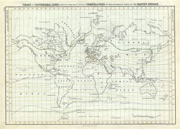
1844 Black Map or Chart of the Isothermal Lines showing the World's Temperatures
1844 (undated) $150.00
1844 Black Map of World Isothermal Lines and Temperature
WorldIsothermal-black-1851$75.00

Title
Chart of Isothermal Lines, Shewing the Mean Annual Temperature of the Different Parts of the Earth's Surface.
1851 (undated) 11.5 x 16.5 in (29.21 x 41.91 cm)
1851 (undated) 11.5 x 16.5 in (29.21 x 41.91 cm)
Description
This is a fine example of Adam and Charles Black's 1851 map or chart of the World's isothermal lines showing the mean annual temperatures in the different parts of the earth's surface. The continents are named while countries are unmarked. The Arctic regions include the voyages and discoveries of several explorers including Hudson in 1607, Phipps in 1773, Tschitsagoff in 1760, Buchan & Franklin in 1819 and Parry in 1827. The coast of Antarctica is drawn in sketchily, based upon early expeditions. Notes Canada's Boothia Felix (at the time believed to be the northern magnetic pole). The map is color coded with isothermal lines featured in green, yellow, red and blue. Various important cities, islands, oceans and other topographical details are marked. This map was engraved by George Aikman as plate no. III-II for issue in the 1851 edition of Black's General Atlas of the World.
CartographerS
Charles and Adam Black (fl. 1807 - present) were map and book publishers based in Edinburgh. Charles and his uncle, Adam, both of Edinburgh, Scotland, founded their publishing firm in 1807. They published a series of maps and atlases throughout the 19th century. In addition to an array of atlases, the Black firm is known for their editions of the Encyclopedia Britannica (1817 - 1826) and the first publishing of Sir Walter Scott's novels in 1854. In 1889 the A. & C. Black publishing house moved to London where it remains in operation to this day. More by this mapmaker...
George Aikman (December 28, 1788 - October 16, 1865) was a Scottish printer, lithographer, and engraver active in the early 19th century. Aikman most likely apprenticed with his father of the same name, also an engraver, before joining the Edinburgh map and atlas firm of William Lizars. Several years later Aikman established himself independently as "George Aikman and Sons, Engravers and Lithographers", publishing numerous maps and prints in conjunction with the larger firm of William and Charles Black, and others. George Aikman's son, also George (1830 - 1905), became an apprentice with the firm around 1842, and eventually a journeyman engraver in Manchester and London, before returning to Edinburgh to take up a full partnership in the family business. Upon the elder Aikman's death in 1865, George became the sole proprietor of the firm and continued to publish until 1876 when he sold the business to pursue a passion for landscape painting. Learn More...
Source
Black, A. and C., General Atlas Of The World, (Edinburgh) 1851.
Condition
Very good. Minor overall toning. Blank on verso.
References
Rumsey 2305.007 (1854 edition). Philips (atlases) 4334.