This item has been sold, but you can get on the Waitlist to be notified if another example becomes available, or purchase a digital scan.
1941 Preston Pictorial WWII Map of the 12th African Division in East Africa
12thAfricanDiv-preston-1941$750.00

Title
12th African Division.
1941 (dated) 19.5 x 16 in (49.53 x 40.64 cm)
1941 (dated) 19.5 x 16 in (49.53 x 40.64 cm)
Description
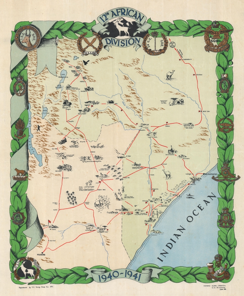
This is a rare 1941 World War II pictorial map of East Africa highlighting the 12th African Division, drawn by J. Preston, a signalman with the Division. This is one of the only WWII route maps we have identified to detail either the East African Campaign or Colonial Troop Units.
A Closer Look
The map depicts parts of British East Africa (Kenya) and Italian Somaliland (Somalia), with Nairobi in the lower left and Mogadishu (Mogadiscio) near the right border. Pictorial vignettes highlight significant places in the 12th African Division's campaign. Aerial attacks, infantry reconnaissance, airfields, and POW camps appear. Convoys are referenced, suggesting that supplies were constantly on the soldiers' minds. The map shares stylistic elements with similar maps of the European theater. However, the insignia decorating the borders incorporate African wildlife and symbolism, underscoring that the 12th African were colonial subjects of the Empire, not British citizens.12th African Division
The 12th African Division was a colonial unit of the British Empire that fought in the East African Campaign during World War II. Originally formed in Kenya on July 19, 1940, the Division was first known as the 2nd African Division. Its designation changed to the 12th on November 24, 1940. Under the command of Lieutenant-General Alan Cunningham, the Division fought from Kenya into Italian Somaliland and then through Ethiopia. It was disbanded on April 18. 1943.The East African Campaign
Also known as the Abyssinian Campaign, the East African Campaign took place from June 1940 through November 1941. An Allied force of British Empire troops fought Italian and Italian colonial units from Italian East Africa. British Empire troops from throughout the Empire fought in the campaign, alongside units from the Belgian Congo, Ethiopian resistance groups, and a contingent of Free French Forces. Combat was split between the Northern and Southern Fronts. In the north, fighting occurred in British Somaliland, Eritrea, and western Ethiopia, while in the south, the British invaded Italian Somaliland from Kenya before advancing into Ethiopia. Organized resistance ended after the November 1941 Battle of Gondar, in northwestern Ethiopia, where 10,000 Italian and 12,000 African troops surrendered. Nonetheless, guerrilla fighting continued until November 1943.Publication History and Census
This map was created by J. Preston of the 12th African Division Signal Corps in June 1941 and printed by the East African Survey Group in November 1941. We note a single cataloged example, in the collection at the Imperial War Museum. A second map created for the 12th African Division was not signed by Preston but was printed by the East African Survey Group in April 1942.Condition
Very good. Mounted on linen.
References
Imperial War Museum Art.IWM PST 15373.