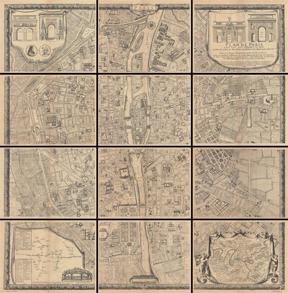
1710 Jaillot Plan or Map of Paris (1900 Taride issue)
1710Paris2-jaillot-1900$3,000.00

Title
Plan De Paris, Levé Par Les Ordres Du Roy Et Par Les Soins De Messieurs Les Prevost Des Marchands Et Eschevins.
1900 (dated 1710) 75 x 75 in (190.5 x 190.5 cm) 1 : 2000
1900 (dated 1710) 75 x 75 in (190.5 x 190.5 cm) 1 : 2000
Description
This majestic twelve panel map or plan of Paris is the c. 1900 Taride reissue of an important map originally prepared by Pierre Bullet, Francois Blonde, A. Bonnardt, and Bernard J. H. Jaillot. Like many early maps of Paris, the present example is oriented to the east. Centered on the Ile de la Cité, this map covers Paris from the Bastille to the western end of the Jardin des Tuilleries and from Montmarte to L'Observatoire. This is a geometric delineation of Paris and offers numerous decorative elements, including profile views of all significant Paris buildings including the Louvre, the Bastille, Notre Dame, the Palais Royale, and countless other palaces, hospitals, monasteries, churches, and monuments. The map was issued at the bequest of King Louis XIV and involved some six years of painstaking survey work. This earliest edition of this map was finally issued in 1676. The present example reflects updates to 1710 with additional public buildings, private mansions, and perspective views. The upper right and left quadrants feature vignettes illustrating the four great gates of Paris: Porte St. Bernard, Porte St. Denis, Porte St. Antoine, and Porte St. Martin. In the lower left quadrant, an exceptionally interesting inset plan details the city's many fountains and subterranean waterworks. Another inset map in the lower right quadrant is entitled the 'environs de Paris'. The whole is surrounded by a decorative oak leaf border.
This map presents dramatically when framed, either separately or together, in twelve tightly spaced panels. It can also be joined by a conservator into a single massive wall map of Paris. This is the c. 1900 Taride reissue. The original 1710 plan is today nearly unobtainable.
This map presents dramatically when framed, either separately or together, in twelve tightly spaced panels. It can also be joined by a conservator into a single massive wall map of Paris. This is the c. 1900 Taride reissue. The original 1710 plan is today nearly unobtainable.
CartographerS
Alexis-Hubert Jaillot (c. 1632 - 1712) followed Nicholas Sanson (1600 - 1667) and his descendants in ushering in the great age of French Cartography in the late 17th and 18th century. The publishing center of the cartographic world gradually transitioned from Amsterdam to Paris following the disastrous inferno that destroyed the preeminent Blaeu firm in 1672. Hubert Jaillot was born in Franche-Comte and trained as a sculptor. When he married the daughter of the Enlumineur de la Reine, Nicholas I Berey (1610 - 1665), he found himself positioned to inherit a lucrative map and print publishing firm. When Nicholas Sanson, the premier French cartographer of the day, died, Jaillot negotiated with his heirs, particularly Guillaume Sanson (1633 - 1703), to republish much of Sanson's work. Though not a cartographer himself, Jaillot's access to the Sanson plates enabled him to publish numerous maps and atlases with only slight modifications and updates to the plates. As a sculptor and an artist, Jaillot's maps were particularly admired for their elaborate and meaningful allegorical cartouches and other decorative elements. Jaillot used his allegorical cartouche work to extol the virtues of the Sun King Louis IV, and his military and political triumphs. These earned him the patronage of the French crown who used his maps in the tutoring of the young Dauphin. In 1686, he was awarded the title of Geographe du Roi, bearing with it significant prestige and the yearly stipend of 600 Livres. Jaillot was one of the last French map makers to acquire this title. Louis XV, after taking the throne, replaced the position with the more prestigious and singular title of Premier Geographe du Roi. Jaillot died in Paris in 1712. His most important work was his 1693 Le Neptune Francois. Jalliot was succeeded by his son, Bernard-Jean-Hyacinthe Jaillot (1673 - 1739), grandson, Bernard-Antoine Jaillot (???? – 1749), and the latter's brother-in-law, Jean Baptiste-Michel Renou de Chauvigné-Jaillot (1710 - 1780). More by this mapmaker...
Alphonse Taride (fl. c. 1850 - 1918) was a prolific Paris based publisher active in the late 19th and early 20th century. Publishing as "A. Taride", the firm produced a large corpus of work including numerous maps, tourist guides, histories, and pocket plans of different parts of France. With the advent of the automobile and improved roadways in the early 20th century, the name "Taride" became synonymous with high quality roadmaps. Taride had his offices at 18 - 20 Boulevard St. Denis, Paris. Learn More...
Condition
Very good. In twelve separate panels. Overall toning - some variance between panels. Original fold lines. Sheets exhibit typical brittleness associated with turn of the century paper. Size indicated represents whole map, if joined. Comes with original binder. Some sheets have repaired tears. Tears repaired on verso.
References
OCLC 228735229, 54243758.