This item has been sold, but you can get on the Waitlist to be notified if another example becomes available, or purchase a digital scan.
1848 Nicholson Map of Mount Morris, Harlem, Manhattan, New York City
27-MountMorrisHomestead-holmes-1848$1,750.00

Title
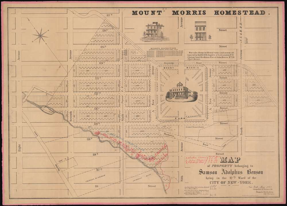
Map of the Property belonging to Samson Adolphus Benson Lying in the 12th War of the City of New-York.
1848 (dated) 23 x 32 in (58.42 x 81.28 cm) 1 : 1800
1848 (dated) 23 x 32 in (58.42 x 81.28 cm) 1 : 1800
Description
A fine example Francis Nicholson's rare 1848 cadastral map of the Mount Morris Park historic district - the only specific map of this area to appear in the 19th century. The map depicts the region from Eighth Avenue to Fourth Avenue and from 127th Street to 116th Street. Streets and avenues are identified and all the buildings and city blocks are numbered. Harlem Creek, which has long since been buried under the development of Manhattan, is illustrated. Manuscript notations in red ink illustrate the land holdings of Abraham Bussing, John Bussing, and Adolph Bussing.
Mount Morris Park
Mount Morris Park, today known as Marcus Garvey Park, is situated just to the right of center. The park interrupts 5th Avenue, because a large 70-foot-high outcropping of schist occupies that patch of land and city builders elected to leave it instead of trying to blast it. The outcropping, originally known as 'Snake Hill' because of the local inhabitants, hosted a Hessian battery during the Revolutionary War and, in the summer of 1969, hosted the Harlem Cultural Festival, which has become known as the 'Black Woodstock'. Today the area around Mount Morris Park is admired for its stunning 19th century brownstones and is one of the most beautiful and desirable neighborhoods in Harlem.Manhattan 'Farm Maps'
In the early 19th century most of Manhattan was undeveloped farm lands, the property of wealthy landowners with claims dating to the Dutch period of New York's history. The northern 2/3rd Manhattan was dotted with farm lands and sprawling gentlemanly estates, many with great manor houses overlooking the Hudson River. The Commissioner's Plan of 1811 and the 1807 Commission Law, laid the street grid through many of these properties and gave the city the right to claim these lands under eminent domain, providing due compensation to the landowners. While this work occurred early in lower Manhattan, central and upper Manhattan were not formally acquired by the city until the mid-19th century.Provenance
This map was acquired as a part of a large collection of New York cadastral maps associated with the layer Ronald K. Brown, a Deed Commissioner operating in the late 19th and early 20th century with an office at 76 Nassau Street, New York - not far from Holmes' own office. Most of the maps in the collection, including the present map, bear Brown's stamp on the verso. The maps were passed to Dominic Anthony Trotta, a real estate agent working under Brown. Brown seems to have ceased business around 1919, but Trotta continued as a real estate agent, becoming a New York Tax Commissioner in 1934 under the Fiorello H. La Guardia administration. The maps remained with Trotta's heirs until our acquisition of the collection.Publication History and Census
This map was created by Francis Nicholson and published after his death in 1848. It is of considerable rarity. The OCLC identifies only one example at the New York Historical Society and we are aware of another example at the Museum of the City of New York.CartographerS
Francis Nicholson (fl. c. 1838 - 1848) was a surveyor for the City of New York. Little is known about his life or career working for the city. More by this mapmaker...
Ferdinand Mayer (October 19, 1817 - November 14, 1879) was a prosperous lithographer based in New York during the latter part of the 19th century. Mayer was born in Württemberg, Germany, but emigrated to the United States following the 1848 March Revolutions that swept through the German Confederation - maybe as late as 1854. Initially, Mayer was associated with various partners, including Prang, Nagel, and Korff - also German immigrants. By 1855, he established himself at 96 Fulton Street and, within a few years, expanded to the neighboring property at 98 Fulton Street. Meyer produced an enormous corpus of varied work, including music sheets, bank notes, broadsides, maps, and views. His career was probably jumpstarted through an early partnership with the important cartographer Henry Walling, many of whose maps and atlases bear the 'Ferd. Mayer' imprint. His most important publication is most likely Egbert L. Vielé's 1865 Topographical Map of the City of New York, one of the most important and influential maps of New York City ever published. The Mayer imprint appears on documents as, variously, 'Ferd. Meyer', 'F. Mayer', and 'Mayer and Sons'. Learn More...
Condition
Good. Original linen. Minor wear and some damage along original fold lines. Even overall toning.
References
OCLC 54761909.