Title
Map showing the perimeters of farms in Bloomingdale and the old roads and lanes as they existed one hundred years ago : belonging to the Cozine, Harson, Hopper, Hegeman, Stake, Stryker, Eden, Tevon, Haynes, Horsmanden, Reis, Kelly, Webber, Cutting, Astor, Emmett and other families.
1879 (dated)
29 x 46.5 in (73.66 x 118.11 cm)
1 : 1800
Description
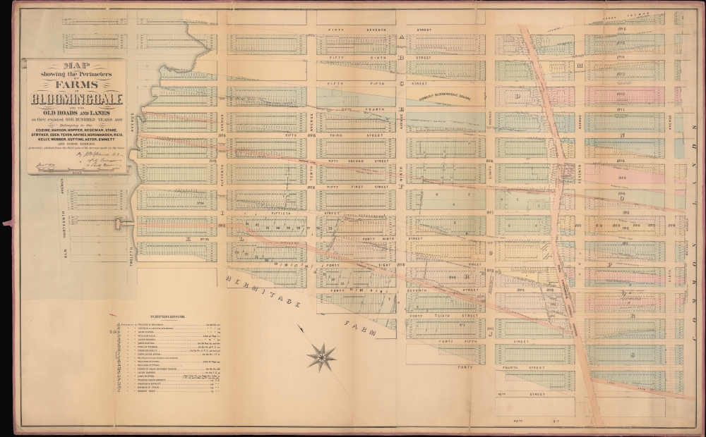
This is a John Bute Holmes 1879 cadastral map of Midtown West, including Times Square and the Theater District. It captures the area during a brief period of widespread development and redistricting.
A Closer Look
The map depicts from the Hudson River to Sixth Avenue and from 57th Street to 42nd Street. Highly detailed, individual lots throughout the neighborhood are numerically identified, while the farms, roads, and lanes that existed in 1779 are both referenced and occasionally superimposed over the 1879 survey. A key in the lower left lists landowners and Holmes's references.Manhattan's Thirteenth Avenue
To increase Manhattan's river-front property, the New York State Legislature passed a law in 1837 to extend Manhattan's western shore into the Hudson River. This project ran along a line soon designated as 13th Avenue, from Hammond Street (today's West 11th Street) to 135th Street. The city began selling lots to developers well before landfill efforts commenced. Developers were then required to follow official instructions on how to fill and develop the lots. This effort was, ironically, sunk for the same reason it started: to make New York one of the world's premier harbors. Within two decades, the legislature reversed course. It prohibited landfilling over 100 feet from 12th Avenue because new superliners required longer piers and deeper berths. The law, moreover, required existing filled lots to be dredged. In 1883, only about a dozen blocks of Thirteenth Avenue remained, which The New York Times called 'a west side thoroughfare of little account'. Today, only one block of Thirteenth Avenue remains, the Gansevoort Peninsula, located between Gansevoort Street and Little 12th Street along 11th Avenue. Gansevoort Peninsula opened in 2023 as a public park, and features an athletic field, a dog park, and Manhattan's first public 'beach'.Holmes' 'Farm Maps'
In the early 19th century, most of Manhattan was undeveloped, the residual property of wealthy landowners with claims dating to New York's Dutch period. The northern 2/3rd Manhattan was dotted with farmlands and sprawling gentlemanly estates, many with great manor houses overlooking the Hudson River. The Commissioner's Plan of 1811 and the 1807 Commission Law, laid the street grid through many of these properties and gave the city the right to claim these lands under eminent domain, providing due compensation to the landowners. While this work occurred early in lower Manhattan, central and upper Manhattan were not formally acquired by the city until the mid-19th century.
Holmes became fascinated by the early history of Manhattan real estate ownership, recognizing the wealth to be accrued by accurately understanding the history of city land ownership, division, and inheritance. Moreover, Holmes allied himself with the corrupt Tweed administration, assuring himself and his allies even greater wealth and political power from the eminent domain seizure of old Manhattan estates. Holmes created a series of maps, reminiscent of John Randall's 'Farm Maps', overlaid with property data, showing the borders of old estates, and notating the breakup of the lands among various heirs. The complex work of compiling the maps earned Holmes a fortune, with one newspaper suggesting on his death in 1887 that some of his maps were worth more than 30,000 USD each. There is no complete carto-bibliography of Holmes' maps, but we believe there to be at least 50, possibly more.Provenance
This map was acquired as a part of a collection of New York cadastral maps associated with the layer Ronald K. Brown, a Deed Commissioner operating in the late 19th and early 20th century with an office at 76 Nassau Street, New York - not far from Holmes' own office. Most of the maps in the collection, including the present map, bear Brown's stamp on the verso. The maps were passed to Dominic Anthony Trotta, a real estate agent working under Brown. Brown seems to have ceased business around 1919, but Trotta continued as a real estate agent, becoming a New York Tax Commissioner in 1934 under the Fiorello H. La Guardia administration. The maps remained with Trotta's heirs until our acquisition of the collection.Publication History and Census
This map was created and published by John Bute Holmes in 1879. It is of considerable rarity. The OCLC identifies only one example at the New York State Library. Although uncatalogued, we believe the New York Public Library may have an example.
Cartographer
John Bute Holmes (March 31, 1822 - May 21, 1887) was an Irish civil engineer, city surveyor, and mapmaker based in New York City in the middle to latter 19th century. Holmes was described as a 'short, stout man, with curly gray hair, a smooth face, and a short, thick neck.' Holmes' father-in-law supplied funds for him to immigrate to America in 1840 and shortly thereafter, in 1844, he established himself in New York City. He briefly returned to Europe before once again settling in New York City in 1848. Apparently, according to several New York Times articles dating to the 1870s, Holmes was a man of dubious personal and moral character. He was involved in several legal disputes most of which were associated with his outrageous - even by modern standards - womanizing. In 1857 he was convicted of forgery of a marriage document and sentenced to 15 years of hard labor at Sing Sing, of which he served 5 before wealthy associates interceded on his behalf for an early release. Holmes seems to have been married to several different women at the same time and to have had an unfortunate attraction to exceptionally young women - one of whom, 16 year old May Chamberlayne claimed to be his wife and sued him for 50,000 USD. On another occasion he was found guilty of killing Brooklyn policeman David Gourly with whose wife he 'had been intimate.' Another woman, Miss Abrams, who he hired as a housekeeper, was repeatedly attacked by Holmes and ultimately driven to madness and was consigned to Bellevue Hospital, where she died. Although he attempted to flee the country rather than face conviction for 4th degree manslaughter, he was ultimately arrested and served one year in prison. During the American Civil War he ran for Alderman of the First Ward, in New York. Despite his legal issues, Holmes was a man of considerable means, with a personal fortune estimated between 100,000 and 500,000 USD - a significant sum in the late 19th century. Much of his wealth is associated with a series of important cadastral maps produced between 1867 and 1875 while he was employed as a surveyor and civil engineer under the corrupt Tweed regime. When Holmes died of an 'apoplectic fit' there was considerable wrangling over his estate among his 7 heirs and 11 children. The cream of his estate where his maps, some of which were valued at more than 30,000 USD in 1887. Holmes lived on a large farm-estate in Fanwood New Jersey. More by this mapmaker...
Condition
Good. Original linen. Wear and toning along original fold lines.
References
OCLC 50572096.