This item has been sold, but you can get on the Waitlist to be notified if another example becomes available, or purchase a digital scan.
1944 Sundberg Map of the World During World War II
3YearsofWar-sundberg-1944$125.00

Title
3 Years of War.
1944 (dated) 15 x 21.5 in (38.1 x 54.61 cm) 1 : 72000000
1944 (dated) 15 x 21.5 in (38.1 x 54.61 cm) 1 : 72000000
Description
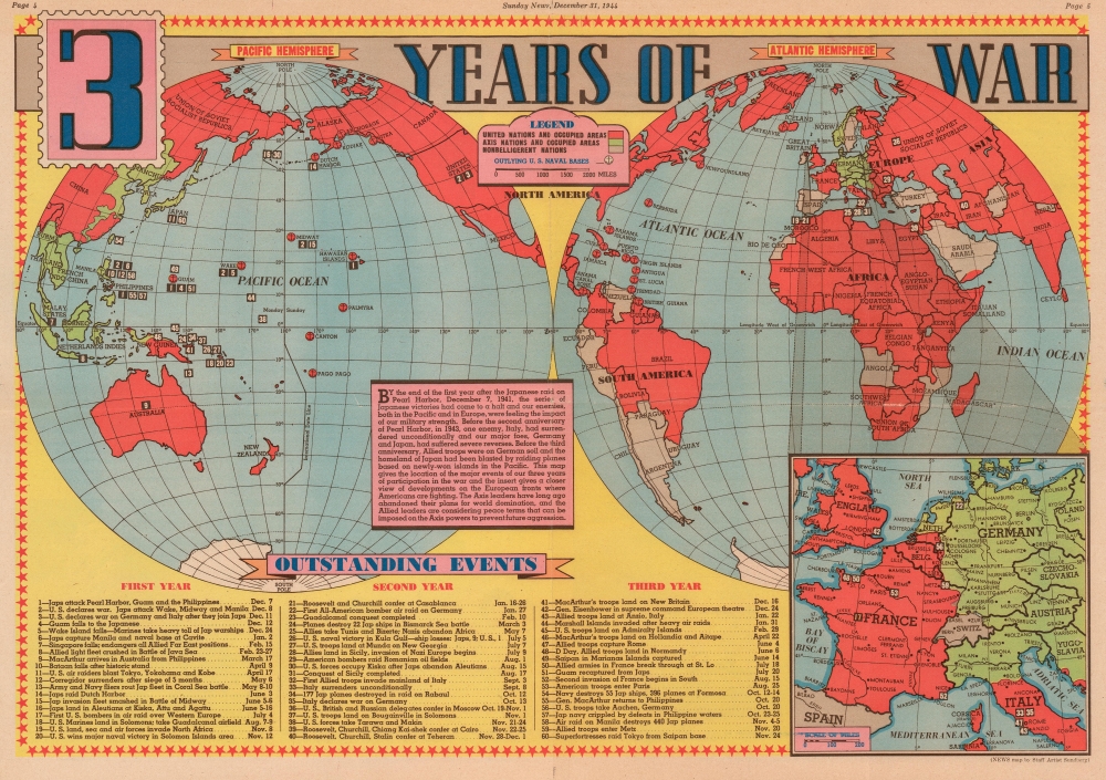
This is a 1944 Edwin Sundberg map of the world during World War II. Published on December 31, 1944, the map provides a visual summary of three years of American involvement in the global conflict. Allied nations are shaded red, while green codes parts of the world still occupied by Germany and Japan. It is worth noting that Leyte, an island in the Philippines that the Allies invaded in October 1944, is shaded red. A text box to the left of center over the South Pacific relates a summary of the three years following the Japanese attack on Pearl Harbor. The text uses that anniversary as a focal point and situates the war's events around that world-changing day. Sixty events from the preceding three years (twenty each) are numerically identified and correspond with an index along the bottom border. This numerical index includes a summary of each battle or event and the date it occurred. Among the noted actions are the Japanese attack on Pearl Harbor, the Battle of Midway, the conquest of Guadalcanal, the invasion of Italy, Italy's surrender, the D-Day landings in Normandy, and the liberation of Paris. An inset, situated in the lower right, focuses on the war in Western Europe and highlights Allied gains.
Publication History and Census
This map was created by Edwin L. Sundberg and published in the December 31, 1944 edition of the Sunday Times. Even though Sundberg's works were produced for a New York City newspaper, his maps appear to have survived poorly and are scarce on the market today. We are aware of only one other example of the present map, part of the David Rumsey Map Collection.Cartographer
Edwin L. Sundberg (1898 - 1978) was an American cartographer known for his pictorial pieces. Sundberg was a staff artist for the Sunday News in New York City and eventually became Chief Cartographer in charge of a small staff of artists. More by this mapmaker...
Condition
Very good. Newsprint. Exhibits wear along original fold lines. Closed margin tears professionally repaired on verso. Text and printed images on verso.
References
Rumsey 12274.000.