1755 D'Anville / Bolton Wall Map of Africa
Africa-boulton-1755$1,000.00


Title
Africa, Performed by the Sr. D'Anville under the Patronage of the Duke of Orleans.
1755 (undated) 39 x 37.75 in (99.06 x 95.885 cm) 1 : 2534400
1755 (undated) 39 x 37.75 in (99.06 x 95.885 cm) 1 : 2534400
Description
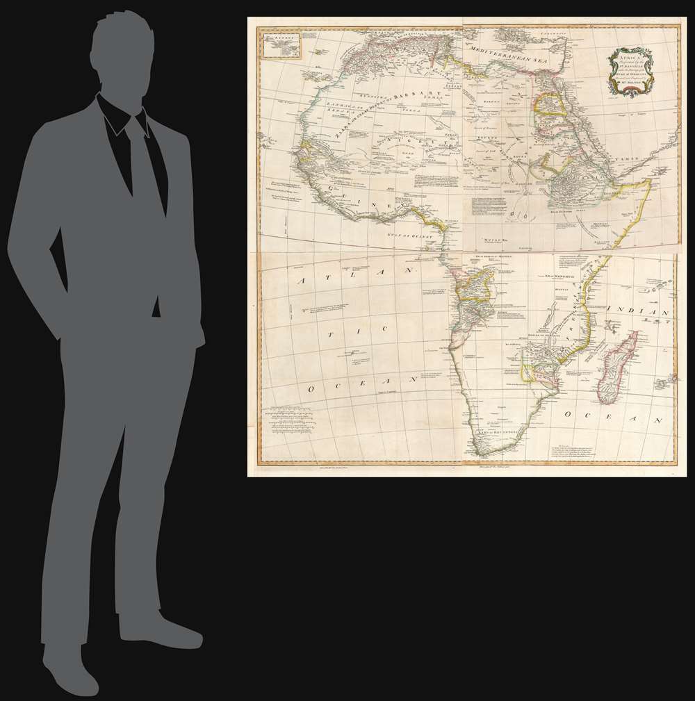
This large and evocative four-sheet 1755 wall map of Africa captures a transitional period in European understanding of African geography. It was bound, in its four separate sheets, in the second volume of Malachy Postlethwayte's The Universal Dictionary of Trade and Commerce. The map is the work of Solomon Boulton, who drafted the map as a largely faithful translation of the illustrious French cartographer Jean-Baptiste Bourguignon d’Anville's 1749 map of the continent. D'Anville was an extremely careful mapmaker, meticulous in detail and scrupulous in the data presented in his work, and for the most part Boulton preserves these qualities while translating the original text and adding an attractive rococo cartouche.
The Map
D'Anville's map presents state-of-the-art cartography for many Africa's coastal kingdoms, and while he does not eliminate many of the erroneous depictions of the interior, he makes strides towards downplaying them. For example, although he includes the imaginary 'Mountains of Kong' and Ptolemy's 'Mountains of the Moon', these features are presented much less boldly than on earlier maps, indicating D'Anville's uncertainty. Vast areas are left blank to indicate clearly European ignorance of the interior. Nevertheless, there is still a wealth of detail, derived from Arab, colonial, missionary, and exploratory penetrations of the continent. The best-mapped parts are found on the Mediterranean Coast, Morocco, the Senegambia, the Congo, South Africa, the Kingdom of Monomatapa, Abyssinia, and Egypt. Morocco, Egypt, and the southern Mediterranean Coast (Barbary), were well known to Europeans since antiquity and D'Anville's accurate mapping of these regions reflects continual exchange. Further south, the colonial enclaves along the Niger River (Senegal and Gambia), the Congo River, and South Africa reflect considerable detail associated with European penetration by traders and missionaries. The land of Monomatapa around the Zambezi River was explored early in the 16th century by the Portuguese in hopes that the legendary gold mines supposedly found there would counterbalance the wealth flowing into Spain from the New Word. Unfortunately, these mines were mostly tapped out by the 15th century.Lake Malawi
A proto-Lake Nyassa or Lake Malawi, here identified as Maravi, appears in a long thin embryonic state that suggests accuracy, although the lake had not been conclusively discovered by Europeans, and would not be until Portuguese trader Candido Jose da Costa Cardoso stumbled upon it in 1849 - one hundred years following D'Anville's presentation of the lake here. D'Anville's inclusion of Lake Malawi is most likely a prescient interpretation of indigenous reports brought to Europe by 17th century Portuguese traders. Its form would be followed by subsequent cartographers well into the mid-19th century when the explorations of John Hanning Speke, David Livingstone, Richard Francis Burton, and others would at last yield a semi-detailed study of Africa's interior.The English Editorial Changes
The map does include notations that do not appear on D'Anville's map. These are likely additions by Postlethwayte himself as editor and author of the volume in which the map appeared. Some of the new annotations pertain to classical or mythological elements neglected in modern cartography (for example the assertions that The ancient Gorgon, where dwelt Medusa and her two Sisters, is the Island of Farulo, Lat. 7. and, in eastern Central Africa, that this part of the Continent about Sofala is with great reason supposed to be the antient Land of Ophir (this latter, the fabled Biblical source of the gold King Solomon used to decorate The Temple).Further Detail
Boulton's map also includes and cites elements from recent English travels. Halley's astronomical measurements fixing the longitude of the Cape of Good Hope are also noted, placing it 'about two Degrees more West than this Author, who would certainly have copied such an Authority, had he known it.' The location of Abomy, 'where the K. Of Dahomy resides' is not included on D'Anville's map. Boulton here cites the Voyages of Smith, Snelgrave, and Atkins, which is telling: Snelgrave's 1734 A New Account of Some Parts of Guinea and the Slave Trade, Atkins' 1735 A Voyage to Guinea, Brazil, and the West-Indies, and Smith's 1744A New Voyage to Guinea were essential early travels describing the workings of the Atlantic Slave Trade, of which Postlethwayte was an enthusiastic supporter.Publication History and Census
This map was engraved by Emanuel Bowen after Boulton's translation of the D'Anville. It was first printed for inclusion in Postlethwayte's 1755 Dictionary of Commerce. Only three examples of the 1755 map are catalogued in OCLC, appearing at Yale, Boston College, and the University of Cape Town. Postlethwayte's The Universal Dictionary of Trade and Commerce is well represented in institutional collections.CartographerS
Malachy Postlethwayt (c. 1707 - 1767) was a British economist and commercial expert famous for his publication of the commercial dictionary titled The Universal Dictionary of Trade and Commerce in 1751. The dictionary was a translation and adaptation of the Dictionnaire économique of the French Inspector General of the Manufactures for the King, Jacques Savary des Brûlons. Malachy claims to have spent nearly 20 years adapting and researching his important dictionary, which attained a popular following. The second edition of the Dictionary issued in 1752, was updated with a series of fine maps based upon D'Anville's work, but updated by Postlethwayt to reflect his political and social views. Politically Postlethwayt was extremely conservative and highly patriotic though his views more often than not took the form of rants against the social and political enemies of the British Empire. In the mid-1740s Postlethwayt lobbied for the Royal Africa Company and was known for his pro-slavery advocacy. His belief that the slave trade had a place in the larger "political arithmetic" of empire, promoted through his many popular books and other publications, in time became the party line for the ruling class. Despite his misguided feelings about the Africa slave trade, Postlethwayt was an influential and thoughtful economist whose ideas influenced Adam Smith, Samuel von Pufendorf, Alexander Hamilton, and others. Postlethwayt also commonly spelled his name as Postlethawyte and Postlethwait. More by this mapmaker...
Jean Baptiste Bourguignon d'Anville (1697 - 1782) was perhaps the most important and prolific cartographer of the 18th century. D'Anville's passion for cartography manifested during his school years when he amused himself by composing maps for Latin texts. There is a preserved manuscript dating to 1712, Graecia Vetus, which may be his earliest surviving map - he was only 15 when he drew it. He would retain an interest in the cartography of antiquity throughout his long career and published numerous atlases to focusing on the ancient world. At twenty-two D'Anville, sponsored by the Duke of Orleans, was appointed Geographer to the King of France. As both a cartographer and a geographer, he instituted a reform in the general practice of cartography. Unlike most period cartographers, D'Anville did not rely exclusively on earlier maps to inform his work, rather he based his maps on intense study and research. His maps were thus the most accurate and comprehensive of his period - truly the first modern maps. Thomas Basset and Philip Porter write: "It was because of D'Anville's resolve to depict only those features which could be proven to be true that his maps are often said to represent a scientific reformation in cartography." (The Journal of African History, Vol. 32, No. 3 (1991), pp. 367-413). In 1754, when D'Anville turned 57 and had reached the height of his career, he was elected to the Academie des Inscriptions. Later, at 76, following the death of Philippe Buache, D'Anville was appointed to both of the coveted positions Buache held: Premier Geographe du Roi, and Adjoint-Geographer of the Academie des Sciences. During his long career D'Anville published some 211 maps as well as 78 treatises on geography. D'Anville's vast reference library, consisting of over 9000 volumes, was acquired by the French government in 1779 and became the basis of the Depot Geographique - though D'Anville retained physical possession his death in 1782. Remarkably almost all of D'Anville's maps were produced by his own hand. His published maps, most of which were engraved by Guillaume de la Haye, are known to be near exact reproductions of D'Anville' manuscripts. The borders as well as the decorative cartouche work present on many of his maps were produced by his brother Hubert-Francois Bourguignon Gravelot. The work of D'Anville thus marked a transitional point in the history of cartography and opened the way to the maps of English cartographers Cary, Thomson and Pinkerton in the early 19th century. Learn More...
Solomon Boulton (fl. c. 1750-1775), sometimes written as 'Bolton,' was an English cartographer active in the middle part of the 18th century. Bolton's most notable works are the adaptions of Jean Baptiste Bourguignon d'Anville (1697 - 1782) maps published in conjunction with Malachy Postlethwayte's Dictionary of Commerce. These were later reprinted and embellished by Sayer and Bennett, and again by Laurie and Whittle. Learn More...
Emanuel Bowen (1694 - May 8, 1767) had the high distinction to be named Royal Mapmaker to both to King George II of England and Louis XV of France. Bowen was born in Talley, Carmarthen, Wales, to a distinguished but not noble family. He apprenticed to Charles Price, Merchant Taylor, from 1709. He was admitted to the Merchant Taylors Livery Company on October 3, 1716, but had been active in London from about 1714. A early as 1726 he was noted as one of the leading London engravers. Bowen is highly regarded for producing some of the largest, most detailed, most accurate and most attractive maps of his era. He is known to have worked with most British cartographic figures of the period including Herman Moll and John Owen. Among his multiple apprentices, the most notable were Thomas Kitchin, Thomas Jeffreys, and John Lodge. Another apprentice, John Oakman (1748 - 1793) who had an affair with and eventually married, Bowen's daughter. Other Bowen apprentices include Thomas Buss, John Pryer, Samuel Lyne, his son Thomas Bowen, and William Fowler. Despite achieving peer respect, renown, and royal patronage, Bowen, like many cartographers, died in poverty. Upon Emanuel Bowen's death, his cartographic work was taken over by his son, Thomas Bowen (1733 - 1790) who also died in poverty. Learn More...
Source
Postlethwayte, M., Mr. Postlethwayt's Universal Dictionary of Commerce, Vol. II, (London) 1755.
Condition
Very good. Original fold lines visible. One mended hole not impacting printed image. Four sheets joined.
References
OCLC 80503563. Tooley, R.V., Guide to maps of Africa, p. 6. Also see Rumsey 13171.007, 008, 009 and 010. (1774 edition).