This item has been sold, but you can get on the Waitlist to be notified if another example becomes available, or purchase a digital scan.
1825 Tanner Map of Africa
Africa-tanner-1825$225.00

Title
Africa.
1825 (undated) 19.5 x 21 in (49.53 x 53.34 cm) 1 : 20000000
1825 (undated) 19.5 x 21 in (49.53 x 53.34 cm) 1 : 20000000
Description
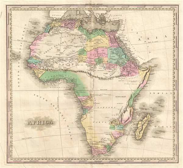
This is an 1825 Henry Schenck Tanner map of Africa. The map depicts the continent of Africa from the Mediterranean Sea and Asia Minor to the Cape of Good Hope and from the Atlantic Ocean and the Cape Verde Islands to the Middle East and the Indian Ocean. The regions along the coast are highly detailed, with different nations and regions illustrated in different colors. Different labeled regions include Algiers, Tunis, Libya, Tripoli, Egypt, Nubia, Abyssinia, Zanguebar, Madagascar, Congo, Guinea, and several others. Myriad cities and towns are labeled in these regions, such as Tunis, Oran, Algiers, Cairo, and Alexandria. The Nile and Niger river systems are depicted in detail. The interior of the continent, however, is much less detailed. Cities along the Niger, such as Timbuktu, are labeled, but the Sahara (Zaara) rather blank, and the interior of sub-Saharan Africa is labeled as 'unknown parts'. Other important aspects of African geography are depicted, including Lake Malawi (L. Maravi), Zanzibar, and Pemba Island. At this point in history Zanzibar was very wealthy and a valuable property under the Sultanate of Oman as it was the main slave market for the Swahili Coast during the 1830s.
Tanner first published this map in 1823. The present example is the scarce 2nd edition from 1825. This map was published in the 1825 edition of Tanner's iconic New American Atlas. This map, like all maps from the New American Atlas, is today rarely seen on the market.
Tanner first published this map in 1823. The present example is the scarce 2nd edition from 1825. This map was published in the 1825 edition of Tanner's iconic New American Atlas. This map, like all maps from the New American Atlas, is today rarely seen on the market.
Cartographer
Henry Schenck Tanner (1786 - May 18, 1858) was one of the preeminent American map engravers and publishers of the early 19th century - what is considered to be the "Golden Age of American Map Publishing". Born in New York City but based in Philadelphia, Tanner's forty plus year career was almost entirely focused on cartographic work. His earliest map work appears in conjunction with another important map publisher, John Melish. Early in his career, Tanner partnered with his brother Benjamin, to engrave extensively for Melish as well as other Philadelphia publishers including Lucas Fielding (Baltimore), A. Bourne, Jason Torey, Samuel Harrison, and Samuel Lewis, among others. In 1818 Tanner convinced his fellow publishers and partners to finance the compilation of a New American Atlas. The atlas was sold by subscription and slowly emerged between 1819 and 1823. The New American Atlas, possibly the pinnacle of 19th century American cartography and was commended in its day as "one of the most splendid works of the kind ever executed in this country". It was subsequently republished in several updated editions until about 1839. Tanner had by this time become the most active and influential map publisher in the United States. Around 1832, recognizing the market for a less cost prohibitive atlas, Tanner began work on the smaller format New Universal Atlas. This popular and important atlas went through numerous editions before being bought out by Carey and Hart, and then, in 1846, by S. A. Mitchell, who would rise to become the preeminent publisher of the next generation. In addition to these important atlases, Tanner also issued numerous extremely important and influential travelers guides, state maps, wall maps, and pocket maps. He should not be confused with his brother, also an America map engraver, the New Yorker Benjamin Tanner. More by this mapmaker...
Source
Tanner, H. S., A New American Atlas, (Philadelphia: Tanner) 1825.
Tanner's New American Atlas is regarding as the largest and most beautiful early American atlas, truly a landmark achievement from the Golden Age of American Cartography. The atlas was initially published in five parts between 1819 and 1823, after which collected editions were issued in 1823, 1825, 1833, and 1839. It terms of size, format, printing quality, paper quality, cartographic accuracy, and elegance of engraving, the New American Atlas was unparalleled. As noted by map historian Walter Ristow, 'Tanner's atlas raised U.S. commercial map production to a new level of excellence.' His contemporaries were also duly impressed. The American educator and historian Jared Sparks, as quoted by Ristow, describes the atlas as thus:
on the whole as an American Atlas, we believe Mr. Tanner’s work to hold a rank far above any other, which has been published. The authentic documents, to which he had access, the abundance of his materials, the apparent fidelity, with which they are compiled, the accurate construction of his maps, and the elegance with which they are executed, all these afford ample proofs of the high character of the work, of its usefulness as a means of extending the geographic knowledge of our own country, and of its claims to public patronage. (Ristow, p. 197)
Condition
Very good. Even overall toning. Verso repair of centerfold separation. Blank on verso.
References
Rumsey 2755.004. OCLC 57239422.