1890 Dosseray Wall Map of Africa

Afrique-dosseray-1890
$1,000.00
Nouvelle Carte de l'Afrique Contenant Toutes les Stations Belges. Nuova Carta dell'Africa Colle Ultime Scoperte. - Main View
Processing...

1890 Dosseray Wall Map of Africa

Afrique-dosseray-1890

The Congo Free State and Scramble for Africa.
$1,000.00

Title


Nouvelle Carte de l'Afrique Contenant Toutes les Stations Belges. Nuova Carta dell'Africa Colle Ultime Scoperte.
  1890 (dated)     29 x 31 in (73.66 x 78.74 cm)     1 : 14665000

Description


This is an 1890 Jean Dosseray wall map of Africa, published five years after the Berlin Conference that defined the Scramble for Africa. Dosseray uses color to illustrate regions claimed by various European powers, including France, England, Spain, Italy, Germany, and Portugal. Some are also identified by flags, including Algeria (France), Angola (Portugal), and Mozambique (Portugal). The bright green region in central Africa represents the Congo Free State, privately owned by King Leopold II of Belgium. The large inset map in the lower left focuses on the Congo Free State and the free economic zone in Central Africa established by the Berlin Conference. A second inset just above focuses on the Nile Delta. The critical Suez Canal is also illustrated.
The Congo Free State
The Congo Free State was a region in Central Africa privately owned by King Leopold II of Belgium. It existed from 1885 until 1908 when it was annexed by Belgium. The annexation followed international pressure to end the atrocities committed under Leopold II. During his time as absolute owner of the Congo Free State, Leopold II's regime extracted rubber, minerals, and ivory from the upper Congo basin and sold them via a series of international concessionary companies. Leopold II gained control of the Congo at the 1884 - 1885 Berlin Conference by convincing Europe's leadership that his goals in the Congo were humanitarian. Leopold lost control of the Congo Free State after news of atrocities committed throughout the country received international recognition. These atrocities came to light thanks to the efforts of the Congo Reform Association, Joseph Conrad's book The Heart of Darkness, the Casement Report, and other sources. Due to the absence of a census, it is impossible to know exactly how many people died in the Congo. Edmund D. Morel estimated that '20 million souls' resided within the Congo Free State at the beginning of Leopold's rulership. Some estimate that half the population died during this time of starvation, disease, a reduction of births, and 'indiscriminate war', putting the death count at around 10 million.
Berlin Conference of 1884-85 / Congo Conference / West Africa Conference
The 1884-85 Berlin Conference was a meeting of colonial powers in Berlin during the New Imperialism Period. The resultant 'General Act of the Berlin Conference' is considered the formalization of the 'Scramble for Africa', wherein much of Africa was partitioned between major European powers (with little regard to the claims and priorities of the indigenous peoples). To claim territory, the delegates needed to prove 'effective occupation', that is, they needed to establish the existence of treaties with local powers, show that their flags were being flown (hence the identification of various flag on this map), or have active forts in the region. The conference marked a major change in the European approach to Africa. Initially European powers treated African peoples much like Native Americans, establishing trading relationships and alliances with indigenous kingdoms. After the Berlin Conference, heightened colonial activity and the need to prove effective occupation lead to the subjugation of most indigenous control.
Publication History and Census
This map was created and published by Jean Dosseray in Brussels in 1890. This is the only known surviving example of the 1890 edition. An example of the 1891 edition is cataloged in OCLC and is part of the collection at the Biblioteca Nacional de España. We also note an example of the 1886 edition in private hands.

Cartographer


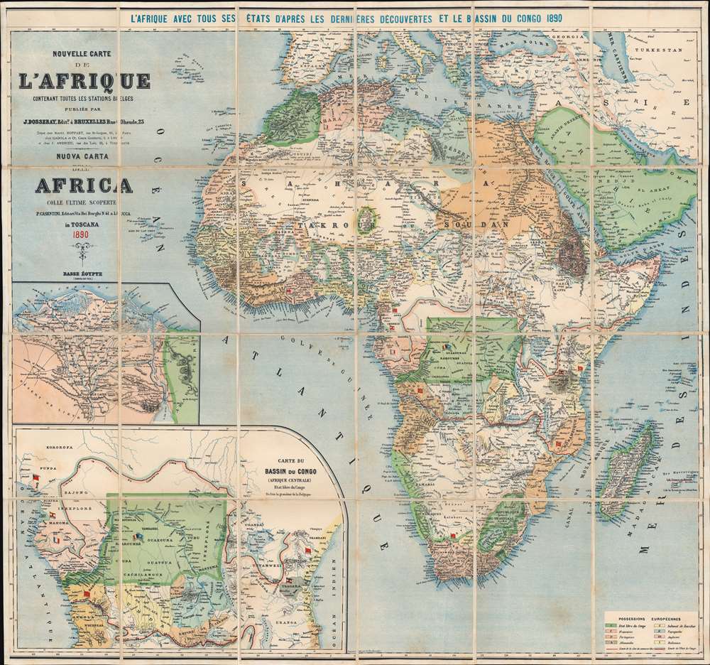
Jean Dosseray (1868 - 1904) was a Belgian publisher and editor active in Brussels during the late 19th century. He published science-based maps for schools and tourists. More by this mapmaker...

Condition


Very good. Dissected and mounted on linen in twenty-four (24) panels. Light foxing.

References


OCLC 431695488.