1786 La Perouse Map of the Southern Coast of Alaska

Alaska1feuille-perouse-1786
$1,000.00
Carte particuliere de la cote du nord-ouest de l'Amerique... - Main View
Processing...

1786 La Perouse Map of the Southern Coast of Alaska

Alaska1feuille-perouse-1786

An early map of the Alaska coastline.
$1,000.00

Title


Carte particuliere de la cote du nord-ouest de l'Amerique...
  1786 (undated)     19.25 x 27 in (48.895 x 68.58 cm)     1 : 3100000

Description


This is a beautiful 1786 map of the southern Alaska coastline made by the French explorer La Perouse. When drawn, it was the only available map of this region not based on the survey work of Captain Cook.
A Closer Look
The map covers a long stretch of the southern Alaska Coast, roughly from Mt. St. Elias (here as St. Elie) in the north to Moresby Island in the south, taking in the present-day settlements of Yakutat and Sitka. Some place names have changed (especially the Spanish ones) while others have simply been Anglicized or only slightly modified; for example, Port Neker at center, towards bottom, is now known as Necker Bay. The coast is not very easily recognizable compared to a modern map since not all the inlets and bays (fjords) were explored by La Perouse's ships, the Boussole and the Astrolabe, whose progress along the coast from late June through mid-August 1786 is also shown. The map is also a nautical chart, noting depths along the coast.

Though it made many important discoveries, La Perouse's journey was dangerous and especially ill-fated, even more so than the last British voyage of Captain James Cook, which it was meant to complement. Groups of crew members were killed in incidents during the voyage, including 42 men lost while exploring Port des Français towards center-top, and ultimately the entire crew died after wrecking on the reefs off Vanikoro, an island in the Santa Cruz group of the Solomon Islands.

It is worth noting that not long after Le Perouse's voyage Russian influence in this area increased through the Russian-American Company. In 1799, the Fort of Archangel Michael (форт Архангела Михаила) was established at Sitka, but it was destroyed in 1802 in a battle with Tlingit warriors and nearly all the Russians killed. The settlement was reestablished as New Archangel or Novo Arkhangelsk two years later and it remained one of the major Russian settlements in Alaska until the territory was sold to the United States.
Publication History and Census
This map was drawn by La Perouse in 1786 and published posthumously as Plate No. 17 in the first edition of the Atlas du Voyage de la Perouse. It was engraved by Bouclet, edited by Hérault (no further information is available on these individuals), and published in Paris by the Imprimerie de la Republique in 1797 (Year 5 of the revolutionary regime). Due to variations in cataloging the map, it is difficult to precisely determine its distribution, but both the map and the entire atlas are known to be held by a handful of libraries in North America and Europe.

Cartographer


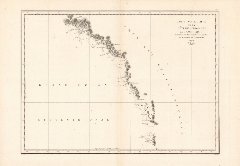
Jean François de Galaup, Comte de La Pérouse (August 23, 1741 - 1788) was a French naval officer, navigator, and explorer active in the later part of the 18th century. Born into a noble family of Albi, France, La Perouse entered the navel college of Brest at just 15. At seventeen La Perouse made his first naval voyage, a supply expedition to the fort of Louisbourg in New France. He later participated in a number of naval battles, mostly against the English, and eventually rose to the rank of Commodore. In 1782 he captured the English forts Prince of Wales and York, making a name for himself back in France. Following the British defeat at the end of the American Revolutionary War, La Perouse was appointed by Louis XVI to lead an expedition of discovery circumnavigating the globe. The goal of the expedition was to complete and correct the maps of the Pacific drawn by Captain Cook. La Perouse's two frigates, the Astrolabe and the Boussole rounded Cape Horn and entered the Pacific in 1785. Crisscrossing the Pacific from Macau and Japan to Alaska, Vancouver, and the Hawaiian Islands Perouse made numerous discoveries and adding considerably to the cartographic corpus, particularly along the coast of British Columbia and around Japan. In Australia La Perouse sent his last letter back to France containing all of his maps and research. Tragically, on the return voyage La Perouse ran into a violent storm which left both of his frigates shipwrecked on the Polynesian island of Vanikoro, part of the Santa Cruz Group. Some of the survivors of the shipwrecks seem to have managed to live on the island for years afterwards. As late as 1790 the English Captain Edward Edwards saw smoke signals coming from Vanikoro but foolishly declined to investigate. Expeditions in 2005 and in 2008 identified the remains of both ships and retuned numerous artifacts from the ill-fated expedition to France. The importance of La Perouse's discoveries was, unfortunately, not seriously appreciated until many years later because, when the La Perouse maps were finally published in 1797, newer more accurate maps of the region were already in circulation. Nonetheless, La Perouse remains of the titans of Pacific exploration and he work paved the path forward for all future expeditions to the region. More by this mapmaker...

Source


Jean-François de Galaup La Pérouse, comte de, Atlas du voyage de La Perouse, (Paris: Imprimerie de la République) 1797.    

Condition


Very good. Only a few minor imperfections.

References


Rumsey 3355.017.