1942 Chapin Map of Algeria and Tunisia
Algeria-chapin-1942$400.00

Title
Algeria.
1942 (dated) 35.25 x 47.5 in (89.535 x 120.65 cm) 1 : 1080000
1942 (dated) 35.25 x 47.5 in (89.535 x 120.65 cm) 1 : 1080000
Description
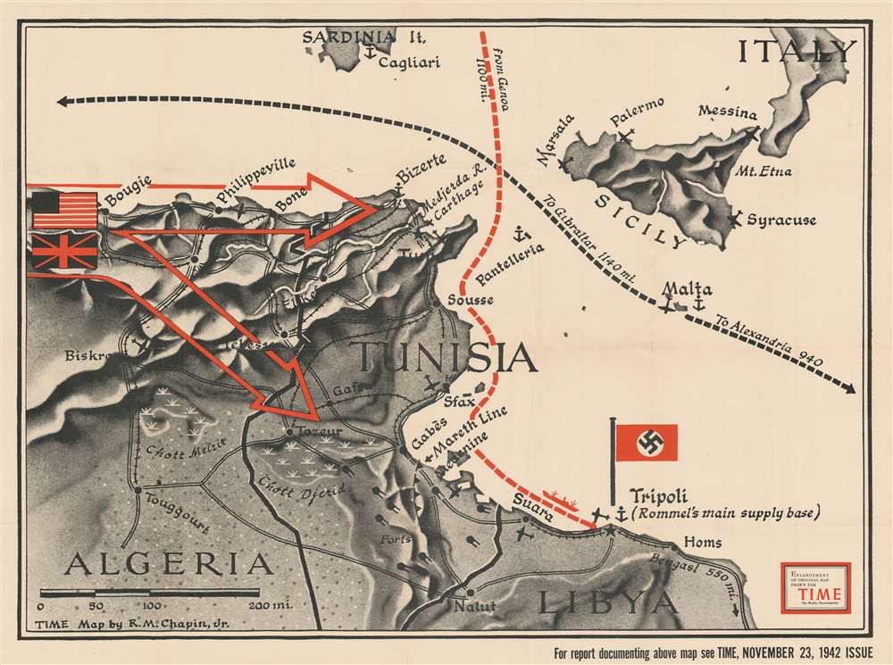
This is a separate issue 1942 Robert M. Chapin, Jr. map of Algeria and Tunisia issued during the World War II North African Campaign. Large red arrows illustrate the American and British forces advancing from the west through Algeria toward Rommel's Afrika Korps in Tunisia. A black dashed line follows Allied supply lines west to Gibraltar and east to Alexandria with the island fortress of Malta at center. Rommel's supply line from Genoa is marked in red.
World War II in North Africa
This map was published two-and-a-half weeks after Operation Torch, the Allied invasion of Morocco and Algeria. The American, British, and French forces that participated in the landings subsequently marched across Morocco and Algeria toward Tunisia. General Sir Bernard Law Montgomery and his 8th Army were fighting Axis forces in a back-and-forth campaign in the western portion of North Africa since 1940. On this map, the 8th Army was approaching Tunisia from the east, squeezing Axis forces between the two armies. Unfortunately for the Allies, delays in the drive across Algeria allowed the Axis forces in Tunisia to reinforce and more than triple their overall strength. The cities of Tunis and Bizerte in northern Tunisia were fortified and the Allies faced an unknown foe in the form of five brand new Pz. VI (Tiger) tanks. Per the Encyclopedia Britannica,The Allies had lost the race to Tunis, but that tactical failure would yield an enormous strategic victory; Hitler and Mussolini were thus induced to pour significant resources into Tunisia at a time when those assets were desperately needed elsewhere.The dogged fighting in North Africa dragged on for another six months, but Axis forces finally surrendered on May 13, 1943.
Publication History and Census
This is a separately-issued enlargement of a map that was created by Robert M. Chapin, Jr. for publication with a TIME Magazine article that appeared in the November 23, 1942 issue. An example is part of the David Rumsey Map Collection.Cartographer
Robert M. Chapin Jr. (fl. 1933 - 1970) was a prominent architect, cartographer and illustrator active during World War II and the Cold War. Chapin graduated from the University of Pennsylvania in 1933 with a degree in architecture. Since this was the height of the Great Depression, and architects in low demand, he instead took work as a staff cartographer at Newsweek. Catching the attention of Manfred Gottfried of Time, Chapin was offered an accepted a position at the head of Time's cartography department. He remained with Time for some 33 years, from 1937 to 1970, often drawn 2 - 3 new thematic maps weekly. With an architect's gift visualizing information, Chapin became a skilled informational cartographer, heading the cartography department at Time Magazine. Chapin, like Fortune Magazine chief cartographer, Richard Edes Harrison, Chapin was at the forefront of infographic propaganda cartography, a genre that matured during the World War II Era and remains popular today. Working for Time Magazine, Chapin developed a signature style for his long run of 'War Maps.' Chapin was known for his maverick airbrush technique which lead to strong color splashes and intense shading. He also incorporated celluloid stencils to illustrate bomb explosions, flags, sinking ships, and more - generating a instantly recognizable standardized style. Chapin's Time war maps were further distinctive for their use of strong bold reds as a universal symbol of hostility. Chapin graduated from the University of Pennsylvania in 1933 with a degree in architecture. Since this was the height of the Great Depression, an d architects in low demand, he instead took work as a staff cartographer at Newsweek. Catching the attention of Manfred Gottfried of Time, Chapin was offered an accepted a position at the head of Time's cartography department. He remained with Time for some 33 years, from 1937 to 1970, often drawn 2 - 3 new thematic maps weekly. Chapin live in Sharon Connecticut. More by this mapmaker...
Condition
Very good. Light wear and toning along original fold lines. Verso repairs to fold separations. Blank on verso.
References
Rumsey 11773.000.