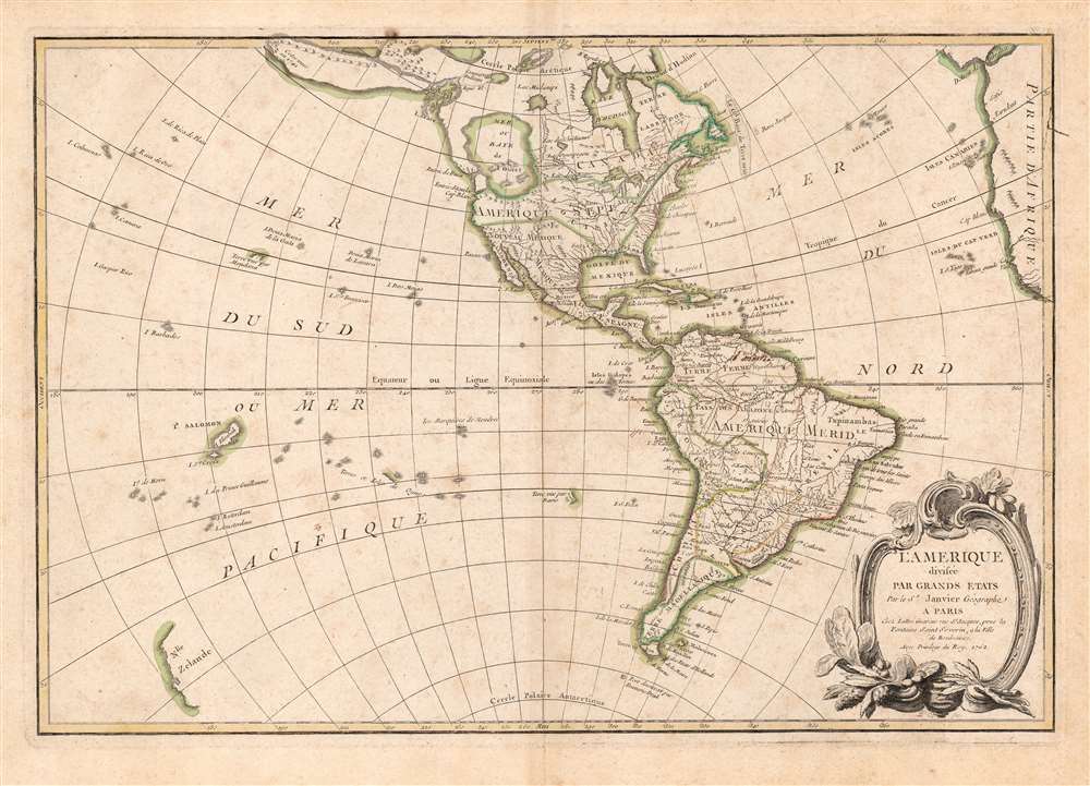
1762 Janvier Map of North America and South America (Sea of the West)
America-lattre-1762-3$750.00

Title
L'Amerique divisee Par Grands Etats.
1762 (dated) 12.5 x 18 in (31.75 x 45.72 cm) 1 : 60000000
1762 (dated) 12.5 x 18 in (31.75 x 45.72 cm) 1 : 60000000
Description
An altogether fascinating 1762 map of North America and South America by Jean Janvier. The map displays the entire continent from the Antarctic Circle to the Arctic Circle, extends westward to New Zealand, and eastward as far as Africa and Spain. This map, which is heavily influenced by the theoretical maps of Joseph Nicolas de l'Isle and Philippe Buache, went through several states of which this is the earliest and possibly the most interesting.
The Sea of the West
By far the most interesting aspects of this map deal with Janvier's treatment of the largely unexplored Pacific Northwest. A tremendous body of water, called the Sea of the West or in this case the 'Baye de L'Ouest,' occupies the greater part of the northwestern portion of the continent. This body of water, alternatively called the Sea of the West or Mer de l'Ouest, was speculated by Philippe Buache and Joseph Nicolas De l'Isle in the early 18th century based upon wishful thinking, the somewhat questionable 16th century explorations of Juan de Fuca, and the utterly fraudulent explorations of the imaginary Admiral De Fonte. Janvier gives the Mer de l'Ouest its fullest expression, though he stops just short of connecting it to either the network of lakes and rivers extending westward from Hudson Bay or to the similar network extending westward from Lake Superior.The North American Interior
These river and lake networks were being actively explored through the early 18th century by a number of little known but important French explorers and Coureur des bois (Fur Trappers). Most specifically the explorations of Coureur des bois Pierre Gaultier de Varennes et de La Vérendrye with regard to the discovery of the Lake of the Woods (L. Des Bois) and Lake Winnipeg (L. Ouinipigon), both of which appear on this map.De Fonte Legend
Further north we can find traces of Admiral de Fonte's equally fictitious discovery of a passage from the Pacific (starting at the Archipel St. Lazare) eastward via a network of lakes and rivers to Baffin Bay. The De Fonte legend first appeared in a 1706 English publication entitled Memoirs of the Curious. This short-lived magazine published a previously unknown account by a supposed Spanish Admiral named Bartholomew de Fonte. De Fonte was said to have sailed up the Pacific coast of North America in 1640. On this voyage he apparently discovered a series of gigantic lakes, seas, and rivers heading eastward from the Pacific towards Hudson Bay. The De Fonte story relates how, on one of these great inland lakes, he met with a westward bound ship from Boston that could only have come through the Northwest Passage. Today, based upon inaccuracies and falsities, we know the entire De Fonte article to have been a fabrication. It nonethless set 18th century Europe afire with speculation that a Northwest Passage must indeed exist. Even such luminaries as Benjamin Franklin wrote long defenses of De Fonte. Our map offers an uncommon variant on the De Fonte passage, positioning its western entrada well to the north in order to accommodate the Sea of the West and situating its outlet at the Baffin rather than the Hudson Bay.The Muller Peninsula?
Even farther to the north we find a striking and exaggerated Alaska-like projection heading in the direction of Asia. This bears some resemblance to the Muller Peninsula postulated around this time based on sightings of the Aleutian archipelago and their misinterpretation as a single land mass. Even more so, given its directional orientation, it bears a significant resemblance to Gamaland or Companie Land as imagined by Sanson. A note at the very edge of this land mass claims that it was seen in 1741, suggesting either Vitus Bering or Alexei Chirikov. Both did, in fact, search for Gama or Companie land that year without significant success.Carto-Advocacy
On the opposite side of the map, Janvier places the Great Lakes firmly within French territory, a clear case of carto-advocacy. He also extends Spanish control of the eastern coast of North America well north of the traditional Florida boundary to include Georgia and parts of Carolina.South America
South America is typically well mapped along the coastlines and relatively speculative along the interior. Janvier drops the popular myth of Lake Parima and Eldorado in Guyana, but maintains the Lac Xarayes as the northern terminus of the Paraguay River. The Xaraiés, meaning 'Masters of the River' were an indigenous people occupying what are today parts of Brazil's Matte Grosso and the Pantanal. When Spanish and Portuguese explorers first navigated up the Paraguay River, as always in search of El Dorado, they encountered the vast Pantanal flood plain at the height of its annual inundation. Understandably misinterpreting the flood plain as a gigantic inland sea, they named it after the local inhabitants, the Xaraies. The Laguna de los Xarayes almost immediately began to appear on early maps of the region and, at the same time, almost immediately took on a legendary aspect as the gateway to El Dorado.Polynesia
Polynesia is mapped with numerous islands named, but few are the correct size or in the correct place. Hawaii, which had not yet been discovered by Cook, is entirely absent. What is shown is 'Terre de Davis' roughly where Easter Island is today. Terre de Davis or Davis' Land was supposedly discovered in 1688 by an English navigator of the same name. Many historians argue whether or not Davis Land was actually Easter Island, but it does seem likely.New Zealand
New Zealand is revealed in an extremely embryonic form in the lower left quadrant. Only the western coast is mapped, in a rudimentary form based on Abel Tasman's reports of the mid 17th century. Maps revealing the two islands of New Zealand would not appear until after Cook's first circumnavigation (1768 - 1771).Publication History and Census
Drawn by Jean Janvier in 1762 for issue as plate no. 31 in Jean Lattre's 1775 issue of the Atlas Moderne. We do not find this separate map in OCLC although it does appear on the market from time to time.CartographerS
Jean Denis Janvier (fl. 1746 - 1776), sometime also known as 'Robert', was a Paris based cartographer active in the mid to late 18th century. Janvier signed his maps Signor Janvier. By the late 18th century, Janvier was awarded the title of 'Geographe Avec Privilege du Roi' and this designation appears on many of his later maps. Janvier worked with many of the most prominent French, English and Italian map publishers of his day, including Longchamps, Faden, Lattre, Bonne, Santini, Zannoni, Delamarche, and Desnos. More by this mapmaker...
Jean Lattré (170x - 178x) was a Paris based bookseller, engraver, globe maker, calligrapher, and map publisher active in the mid to late 18th century. Lattré published a large corpus of maps, globes, and atlases in conjunction with a number of other important French cartographic figures, including Janvier, Zannoni, Bonne and Delamarche. He is also known to have worked with other European cartographers such as William Faden of London and the Italian cartographer Santini. Map piracy and copyright violations were common in 18th century France. Paris court records indicate that Lattré brought charges against several other period map publishers, including fellow Frenchman Desnos and the Italian map engraver Zannoni, both of whom he accused of copying his work. Lattré likes trained his wife Madame Lattré (né Vérard), as an engraver, as a late 18th century trade card promotes the world of 'Lattré et son Epouse.' Lattré's offices and bookshop were located at 20 rue St. Jaques, Paris, France. Later in life he relocated to Bordeaux. Learn More...
Source
Lattre, Jean, Atlas Moderne ou Collection de Cartes sur Toutes les Parties du Globe Terrestre, (Paris) c. 1775.
Condition
Very good. Original centerfold.
References
Rumsey 2612.069 (1783 edition.) Phillips (Atlases) 629-32. New York Public Library, Map Division, 96-7687. This state not in OCLC.