1825 Tanner Map of North and South America
America-tanner-1825$950.00

Title
America.
1825 (undated) 20 x 24 in (50.8 x 60.96 cm) 1 : 44000000
1825 (undated) 20 x 24 in (50.8 x 60.96 cm) 1 : 44000000
Description
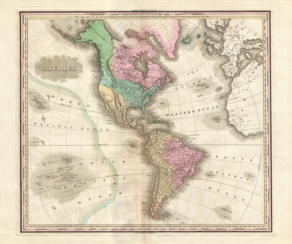
This is an 1825 Henry Shenk Tanner map of the Americas and the Western Hemisphere.
Concerning North America, the division of color is intriguing. The United States is labeled along the Appalachian Mountains, while the Missouri Territory stretches from the Mississippi River to the Pacific.
A Closer Look
The map centers on North and South America, covering from Alaska, Canada, and Greenland south to Tierra del Fuego and the Falkland Islands. It depicts from Hawaii (Sandwich Isles) and several archipelagos in the South Pacific (the Society Islands, Marquesas, and the 'Dangerous Archipelago') east across the Americas and the Atlantic Ocean to Europe and the west coast of Africa. However, only North, Central, and South America are colored.Concerning North America, the division of color is intriguing. The United States is labeled along the Appalachian Mountains, while the Missouri Territory stretches from the Mississippi River to the Pacific.
The Oregon Question
The northern border of the United States also extends well into British Columbia, referring to the Oregon Question and the 54°40' dispute. The northern border is not depicted at the 49th parallel, which is the contemporary border between the United States and Canada, but rather at the parallel 54°40' north, which was the border with Russian America and well into modern-day British Columbia. The Oregon Question was disputed for decades between the United States and Great Britain. The basis for the dispute was primarily economic. The Pacific Northwest was the final frontier of the fur trade, which meant that both British and American interests wanted regional control. American interest in the region also came back to the concept of Manifest Destiny and the Westward Expansion. Although the border was set at the 49th parallel by 1846, the crisis was not fully resolved until 1872.Spanish America
The American border with Mexico, or New Spain, follows the Sabine River, the Red River, the Arkansas (Arkensaw) River, and the northern border of California. Yellow represents Spanish-claimed territory from California to Patagonia - although most of these regions at this time were embroiled in the Latin American Wars of Independence. South America contains two other color divisions: Amazonia and Patagonia. Amazonia consists of most of modern-day Brazil, as well as Uruguay, and parts of Argentina and Paraguay. The Caribbean islands (West Indies) are depicted in detail.Publication History and Census
Tanner first published this map in 1823. The present example is the scarce 2nd edition from 1825. This map was published in the 1825 edition of Tanner's iconic New American Atlas. This map, like all maps from the New American Atlas, is today scarce to the market.Cartographer
Henry Schenck Tanner (1786 - May 18, 1858) was one of the preeminent American map engravers and publishers of the early 19th century - what is considered to be the "Golden Age of American Map Publishing". Born in New York City but based in Philadelphia, Tanner's forty plus year career was almost entirely focused on cartographic work. His earliest map work appears in conjunction with another important map publisher, John Melish. Early in his career, Tanner partnered with his brother Benjamin, to engrave extensively for Melish as well as other Philadelphia publishers including Lucas Fielding (Baltimore), A. Bourne, Jason Torey, Samuel Harrison, and Samuel Lewis, among others. In 1818 Tanner convinced his fellow publishers and partners to finance the compilation of a New American Atlas. The atlas was sold by subscription and slowly emerged between 1819 and 1823. The New American Atlas, possibly the pinnacle of 19th century American cartography and was commended in its day as "one of the most splendid works of the kind ever executed in this country". It was subsequently republished in several updated editions until about 1839. Tanner had by this time become the most active and influential map publisher in the United States. Around 1832, recognizing the market for a less cost prohibitive atlas, Tanner began work on the smaller format New Universal Atlas. This popular and important atlas went through numerous editions before being bought out by Carey and Hart, and then, in 1846, by S. A. Mitchell, who would rise to become the preeminent publisher of the next generation. In addition to these important atlases, Tanner also issued numerous extremely important and influential travelers guides, state maps, wall maps, and pocket maps. He should not be confused with his brother, also an America map engraver, the New Yorker Benjamin Tanner. More by this mapmaker...
Source
Tanner, H. S., A New American Atlas, (Philadelphia: Tanner) 1825.
Condition
Very good. Even overall toning. Light soiling.
References
Rumsey 2755.005. OCLC 57245707.