This item has been sold, but you can get on the Waitlist to be notified if another example becomes available, or purchase a digital scan.
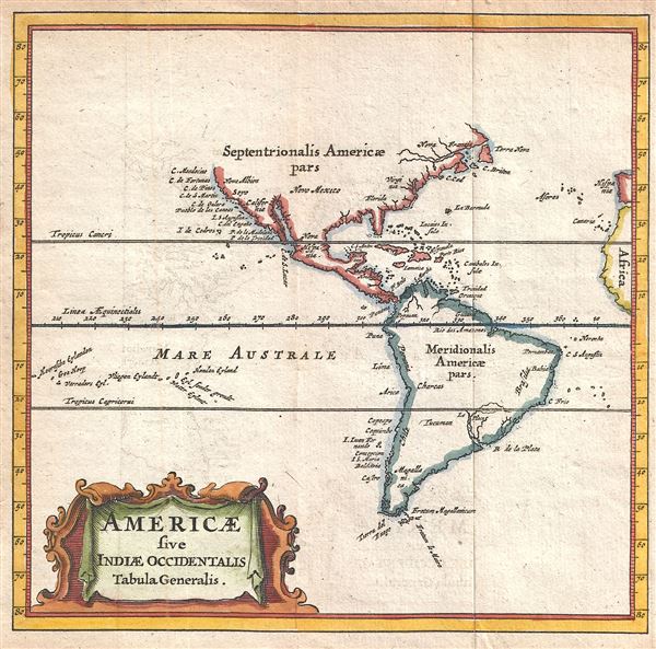
1661 Cluver Map of North America and South America
Americae-cluver-1661$112.50

Title
Americae sive Indiae Occidentalis Tabula Generalis.
1661 (undated) 5 x 5 in (12.7 x 12.7 cm) 1 : 160000000
1661 (undated) 5 x 5 in (12.7 x 12.7 cm) 1 : 160000000
Description
A scarce and attractive 1661 miniature map of the the Americas by Philipp Cluver. A reduced version of the 1630 De Laet map, Cluver's map presents the Americas according to the geographical conventions of the time. The map offers primarily coastal details. On the east coast, the only place name of note is Cape Cod, although Virginia and Florida are also mentioned. The west coast, by contrast, features numerous coastal sites. This map was issued for the 1661 edition of Cluver's Introductionis in Uniersam Geographiam.
Cartographer
Philipp Clüver (also Klüwer, Cluwer, or Cluvier, Latinized as Philippus Cluverius and Philippi Cluverii) (1580 - December 31, 1622) was a German geographer and historian active in Leiden in the late 16th and early 17th centuries. Clüver was born in the Royal Prussian city of Danzig (Gdansk), then a province of the Kingdom of Poland. He study of law at the University of Leiden before turning his attention to history and geography. Cluver traveled, mostly by foot, extensively throughout Europe, spending time in Germany, England, Scotland, Holland and Italy. On returning to Leiden he was given a special appointment as geographer and put in charge of the university's library. Cluver is best known for his general study of the geography of antiquity. A popular Enlightenment era field of study, antiquarian geography attempted to resolve place names known from classical literature but, by the time of the Renaissance, geographically confused. Cluver based his research not only on classical literary sources, but — and this was his primary contribution to the genre — also his extensive and local inspections of sites. Today he is considered one of the founding fathers of historical geography. Cartographically Cluver's most prominent works include his edition of Ptolemy's Geographia (based on Mercator's edition of 1578) and for miniature atlases that were reprinted for most of the 17thand 18th centuries. Cluver was also known as Klüwer, Cluwer, or Cluvier, Latinized as Philippus Cluverius and Philippi Cluverii. He died in Leiden in 1622. More by this mapmaker...
Source
Cluver, P., Introductionis in Universam Geographiam tam veterem quam novam Libri VI, (Amsterdam) 1661.
Condition
Very good. Original fold lines. Some transference. Blank on verso.