This item has been sold, but you can get on the Waitlist to be notified if another example becomes available, or purchase a digital scan.
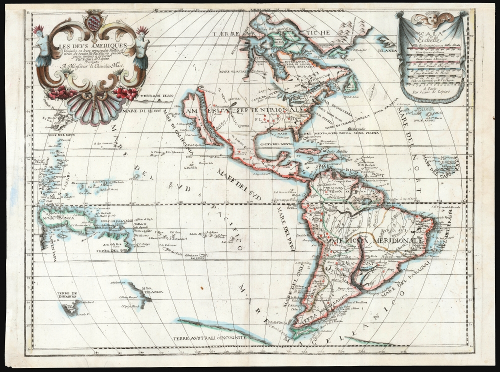
1695 Louis de Lépine map of America, with California as an Island
Americas-lepine-1695$1,500.00

Title
Les Deus Ameriques Divisées en leurs principales Parties, et tirees de toutes les Relations qui ont Par Louis de Lepine Presentee A Monsieur de Chevalier Mari.
1695 (undated) 17 x 22.25 in (43.18 x 56.515 cm) 1 : 37500000
1695 (undated) 17 x 22.25 in (43.18 x 56.515 cm) 1 : 37500000
Description
This is an extremely rare, separately published c. 1695 map of the Western Hemisphere by Louis de Lépine, featuring California as an island. The map also presents the limits of the Pacific Ocean, showing parts of Tasmania, the west coast of New Zealand, part of Japan, and the coastline of the conjectural Terra de Iesso.
The Map and its Maker
This map appears to be the sole surviving cartographic output of Louis de Lépine. Virtually nothing is known of Lepine, except by the appearance of his name on a variety of French-Italian dictionaries, and French-language texts on the Italian language. Some of these were published in Paris but most were printed in Venice. This may go some way to explain this particular map, which is essentially a transcription of the western portion of Jaillot's 1674 or 1691 Mappe-Monde, with the body text of the map translated from French to Italian. Apart from Lépine having altered the map's projection, it is otherwise a close copy of a popular, decorative, but no longer state-of-the-art map. As such, it proved a disappointment to Carl Wheat: '… no hint there appeared respecting French discoveries in the Mississippi Valley, and in Il Novo Mexico the geography displayed was that of almost a century earlier, with the big lake and the R. del Nort flowing into the Mare Vermiglio…'. In his denigration of the map, however, Wheat missed its likely purpose: to provide the French reader with Italian geographical terminology. While Lépine produced no other known cartographic work, what does remain in institutional collections are French-Italian dictionaries, and French language textbooks for learning Italian.Publication History and Census
This map was engraved and separately issued by Louis de Lépine, with a Paris imprint. McLaughlin, Wheat, and Wagner all agree on a 1695 date for this map. The description in McLaughlin includes a date as part of the map's imprint which is absent here. Also, scrutiny of the dedication to 'Monsieur le Chevalier Mari' shows it to have been engraved over an earlier, now-illegible dedication. Thus we suspect that there exists at least two states of the map, one with the date and one without, and perhaps a further with a different dedication. We see a single copy listed in OCLC, state indeterminate, held at the University of California at Berkeley. We see no instances of this map in dealer's listings or auction records.Cartographer
Louis de Lépine (fl. 1683-1699) was a French writer and educator, possibly native to Italy, who wrote and corrected a number of French-Italian dictionaries published in Paris and Venice near the end of the 17th century. He is known to have produced one separately-issued map of the Western Hemisphere, likely as an educational tool. Nothing is known of his background or life beyond his published work. More by this mapmaker...
Condition
Fair. Cropped into border with some loss, upper margin reinstated. Else a bright, attractive example of an unacquirable rarity.
References
OCLC 21812057. McLaughlin, G.G., The Mapping of California as an Island, 116. Wheat, C. I., Mapping of the Transmississippi West, 1540 – 1861, #75. Wagner, H. R., The Cartography of the Northwest Coast of America to the Year 1800, volume II, #445.