1833 Hérisson Folding Wall Map of North America and South America
Amerique-herisson-1833$2,500.00
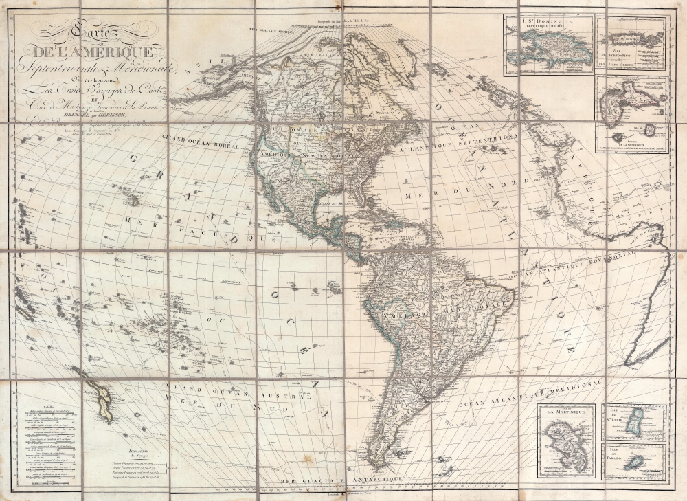

Title
Carte de l'Amérique Septentrionale et Meridionale, ou se trouveur les Trois Voyages de Cook et Ceux de MacKenzie, Vancouver et La Perouse, Parry et Franklin, Dresée par Herisson, eleve de Bonne, ancien Ingénieuo hydrographe de la Marine.
1833 (dated) 36 x 49 in (91.44 x 124.46 cm)
1833 (dated) 36 x 49 in (91.44 x 124.46 cm)
Description
A most unusual and intriguing 1833 wall map of America by Eustache Hérisson. The map makes a number of interesting and curious claims regarding multiple possibilities for a Northwest Passage - attempting to reconcile factual discovery, with apocryphal popular legends, and outright wishful thinking. It covers the western hemisphere, focusing on North and South America, and the surrounding oceans. Full coverage extends east to include the coasts of Europe and Africa, and west as far as New Caledonia and New Hebrides. As the title suggests, tracks follow the maritime routes of important explorers, including Cook, Vancouver, La Perouse. The map also notes the overland expeditions of Mackenzie (1780) and Hearne (1772). Further north, the 1819 - 1820 discoveries of William Edward Parry, and John Franklin's 1819 Coppermine Expedition and 1823 Mackenzie River Expeditions are noted.
Maldanado claimed to have traversed the passage in 1588, a voyage he recounts in his Relación del descubrimiento del Estrecho de Anian. The Relación was presented to the Spanish crown and circulated in manuscript, but remained little-known and unpublished until 1788. To years later, in 1790, the Relación caught the attention of the positivist cartographer Jean-Nicholas Buache de Neuville (1741 - 1825), whose used it to support his own geographic speculations in a paper presented at the Paris Académie des Sciences. The influence of the Académie was such that Spain tasked the Malaspina Expedition (1789 - 1794) to determine the truth of the matter. In the wake of the Relación's resurgence in scientific circles, it was republished in 1811 and again in 1812, drawing general attention. Maldonado was widely discredited in 1849 by Fernandez Navarrete.
The tale of De Fonte' discoveries in the American Northwest had an enduring influence on cartographic representations of America through the second half of the 18th century and early 19th century. The De Fonte legend first appeared in a 1706 English publication entitled Memoirs of the Curious. This short-lived magazine published a previously unknown account by a supposed Spanish Admiral, Bartholomew de Fonte. De Fonte reportedly sailed up the Pacific Coast of North America in 1640. On this voyage, he reports discovering a series of gigantic lakes, seas, and rivers heading eastward from the Pacific towards Hudson Bay. The De Fonte story relates how, on one of these inland lakes, he met with a westward bound ship from Boston that must have come through the Northwest Passage. At the same time, De Fonte sent one of his sub-captains, Pedro Bernarda, northward to explore a 'beautiful river with deep calm waters.' This sub-exploration led to the discoveries of Lake Valasco, R. Bernarda, and Lac Bernarda - as seen here. Today, based upon inaccuracies and falsities, most believe the entire De Fonte legend to have been a fabrication. Nonetheless, it set 18th century Europe afire with speculation. Even such luminaries as Benjamin Franklin wrote emphatic defenses of De Fonte.
Struggling with the Pacific Northwest - Still
Despite the remarkable explorations of Cook, Vancouver, La Perouse, and Parry - and the many accurate maps they produced, the American Arctic, particularly the Pacific Northwest, remained an intractable mystery to cartographers. Here, factual discoveries struggle for reconciliation with debunked legends and the persistent hope for a practical northwest passage.An Inland River Route
The Great Slave Lake, discovered by Samuel Hearne in 1771, and visited again by John Franklin in 1823, is here connected via the 'Entrée de Chesterfield' (Chesterfield Inlet) to the Hudson Bay on the east, and via the factual Mackenzie River and the fictional 'R. de los Reyes' and 'L. Belle' to the Pacific.The True Northwest Passage - but not then
An alternative northwest passage extends from the Fox Canal and Melville Peninsula through the Strait of Hecla (Fury and Hecla Strait) in the 'Mer Polaire'. The cartographer correctly recognizes sighting of the Polar Sea at the mouth of the Coppermine and Mackenzie Rivers, but fails to account for the fact that 'Nord Somerset' was for all intent and purposes a peninsula (it's an island, but at the time, all passages where perpetually frozen). So, the only access to this 'sea' would be via the Strait of Barrow, north of Cumberland Island. Following this passage, one could in theory reach the Barrow Sea north of Alaska, and thence the Bering Strait, but in general, this route was impractical and closed - at least until global warming did its magic in the 20th century.Kiteguen and Kioumi
This is one of only a few maps to include the geography of the Spanish adventurer Lorenzo Ferrer Maldonado (c. 1550 - 1625) - here represented by the fictional lands he 'discovered', Kiteguen and Kioumi, stretching across the Arctic from the Bering Strait to Greenland. Kiteguen was supposedly a continent sized landmass attached to Greenland, thus sheltering an inland sea, Mer Polaire, from the polar ice creating a navigable passage from Atlantic to Pacific.Maldanado claimed to have traversed the passage in 1588, a voyage he recounts in his Relación del descubrimiento del Estrecho de Anian. The Relación was presented to the Spanish crown and circulated in manuscript, but remained little-known and unpublished until 1788. To years later, in 1790, the Relación caught the attention of the positivist cartographer Jean-Nicholas Buache de Neuville (1741 - 1825), whose used it to support his own geographic speculations in a paper presented at the Paris Académie des Sciences. The influence of the Académie was such that Spain tasked the Malaspina Expedition (1789 - 1794) to determine the truth of the matter. In the wake of the Relación's resurgence in scientific circles, it was republished in 1811 and again in 1812, drawing general attention. Maldonado was widely discredited in 1849 by Fernandez Navarrete.
Kiteguen and De Fonte
On the present map, the cartographer uses the presumption of Kiteguen to validate the apocryphal De Fonte discoveries in the face of Mackenzie and Herne's sighting of the Polar Sea. These include 'Lac Valasco' and 'Lac Bernalda' (Bernarda) and an inland river system connecting them to the inter-coastal waterways near Sitka (Alaska).The tale of De Fonte' discoveries in the American Northwest had an enduring influence on cartographic representations of America through the second half of the 18th century and early 19th century. The De Fonte legend first appeared in a 1706 English publication entitled Memoirs of the Curious. This short-lived magazine published a previously unknown account by a supposed Spanish Admiral, Bartholomew de Fonte. De Fonte reportedly sailed up the Pacific Coast of North America in 1640. On this voyage, he reports discovering a series of gigantic lakes, seas, and rivers heading eastward from the Pacific towards Hudson Bay. The De Fonte story relates how, on one of these inland lakes, he met with a westward bound ship from Boston that must have come through the Northwest Passage. At the same time, De Fonte sent one of his sub-captains, Pedro Bernarda, northward to explore a 'beautiful river with deep calm waters.' This sub-exploration led to the discoveries of Lake Valasco, R. Bernarda, and Lac Bernarda - as seen here. Today, based upon inaccuracies and falsities, most believe the entire De Fonte legend to have been a fabrication. Nonetheless, it set 18th century Europe afire with speculation. Even such luminaries as Benjamin Franklin wrote emphatic defenses of De Fonte.
Beyond North America
Beyond the Arctic and North American, the map offers additional items of interest. Colombia is presented in its fullest form as Grande Colombie, including all of modern-day Ecuador, Columbia, and Venezuela, and Guyana. Lake Parima, mythical site of El Dorado from the 15th century, is here correctly associated with Lake Amuku, in Guyana. Several mines are noted in the Matto Grosso. Lake Xarayes, another speculative El Dorado, remains at the northern terminus of the Paraguay River.Publication History and Census
Hérisson first published a map of this (roughly) title in 1795, in a much smaller format. The map was regularly updated as additional explorations and discoveries reshaped the cartographic image of the Americas. We note editions in 1810, 1817, 1819, and 1821. This edition, 1833, issued by Maison Basset well after Hérisson's death, is a fully new plate nearly twice the size of the earlier editions. We note an example of this edition at the Huntington Library, and nowhere else. Rare.CartographerS
Eustache Hérisson (1759 – 1818) was a French cartographer and geographical engineer active in Paris during the early years of the 19th century. Hérisson was a student of the 18th century hydrography Rigobert Bonne. He was a member of the Société Royale. Much of his work was republished posthumously by Bassett, Brue, and others. More by this mapmaker...
Maison Basset (1819 - 1865) was a French publishing concern active through the mid to late 19th century. The firm can trace their roots to André Basset (Bassett; fl. 1768 - 1784), who starting publishing maps, prints, and books around 1768. Maison Basset, also Chez Basset, is the imprint under which the heirs of Paul-André Bassett (1759 - 1829) operated after his death. From their offices at 64 Rue St. Jacques, then 33 Rue de Seine, Paris, France, Maison Basset published the works of such prominent French cartographers and engravers as Barbie du Bocage, A. Vuillemin, J. B. Charle, V. Levasseur, Tu. Duvotenay, H. Dufor, F. E. George, and others. Their library of publications is diverse and vast, but heavily focused on medical and scientific texts, including several important atlases. The firm is closely aligned with the Chéreau family of printers and engravers, with whom they were connected with multiple, often incestuous, marriages and remarriages. Learn More...
Condition
Good. Some spotting. Dissected and laid on linen in 32 sections. Relined with fresh linen. Minor spotting.
References
Huntington Library, #105:697 M.