1674 Jaillot Map of North America (first edition) (California as an Island)
AmeriqueSeptentrionale-jaillot-1692-2$3,000.00

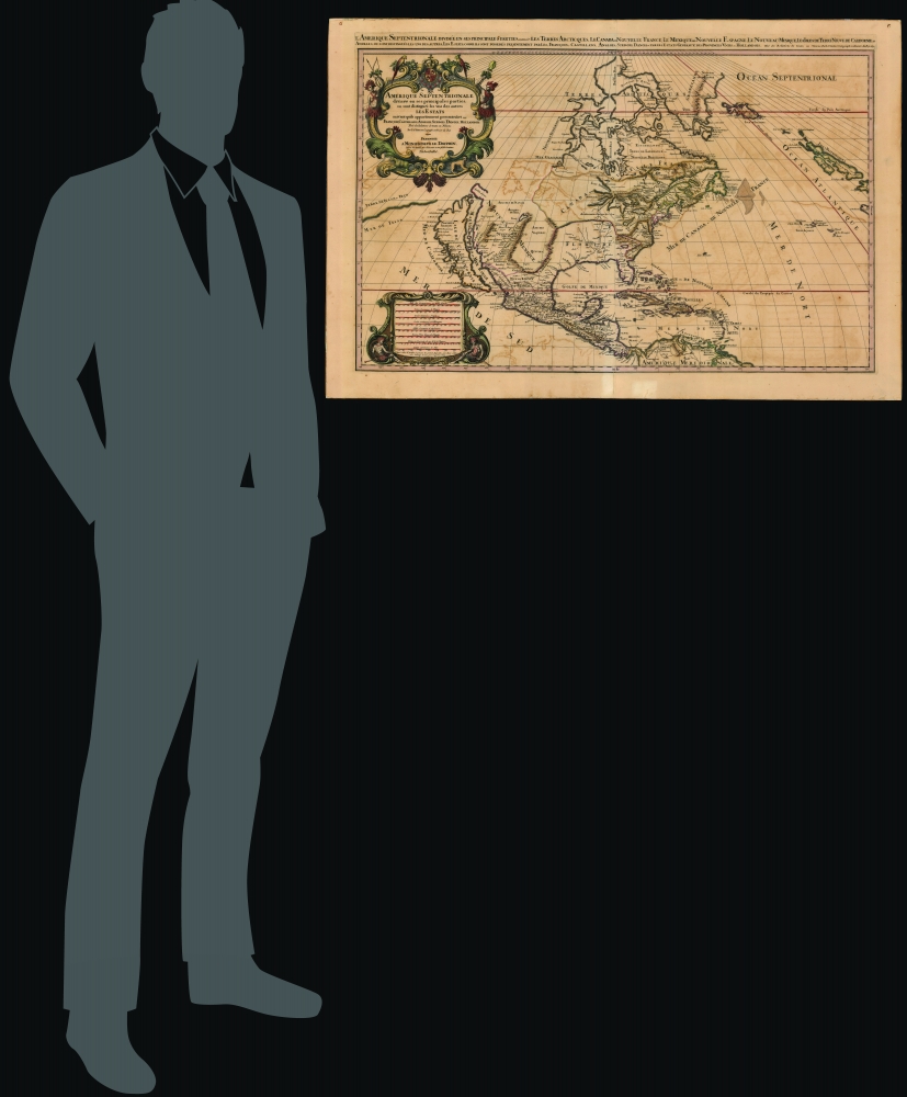


Title
Amerique septentrionale divisée en ses principales parties, ou sont distingués les vns des autres les estats suivant qu'ils appartiennent presentemet aux Francois, Castillans, Anglois, Suedois, Danois, Hollandois, tirée des relations de toutes ces nations par le S. Sanson, geographe ordinaire du roy. 1692.
1692 (dated) 23 x 35 in (58.42 x 88.9 cm) 1 : 16000000
1692 (dated) 23 x 35 in (58.42 x 88.9 cm) 1 : 16000000
Description
This is Alexis-Hubert Jaillot's impressive and scarce 1692 map of North America. The map offers much of interest, including a bold presentation of California as an Island, evidence of otherwise unpublished preliminary data from the 1673 Marquette-Joliett Expedition of the upper Mississippi watershed, a hopeful open-ended mapping of the western Great Lakes, and a large apocryphal freshwater sea in Appalachia.
A Closer Look
The map covers North America and Central America from Baffin Bay to the Spanish Main. It extends westward past an Insular California to include Terre de Iesso (a speculative mapping of Hokkaido) and eastwards past the Azores to include the British Isles. It includes a striking mapping of the Mississippi (Chucagua), which, while inaccurate in the southernmost regions, likely reflects Joliet's verbal reports from the seminal 1673 Marquette-Joliet Expedition.Unusual Mississippi River
The Mississippi River is here identified as 'Chucagua,' a term derived from the journals of the De Soto Expedition. De Soto crossed the Mississippi River in 1541, naming it after the wild garlic that grew prolifically on the river edge, named in Algonquin shikaakwa. (This is the same term that the city 'Chicago' is named after.) The term was transliterated into French for the 1670 translation of De Soto's journals by Pierre Richelet as the 'Chucagua River'. The same is also frequently called 'De Soto's River'. Mapped here by Jaillot, the river has its outlet in 'Bahia del Spiritu Santo', likely Galveston Bay, but inland bends sharply east, then north, to roughly correspond to the Upper Mississippi. This is a cartographic innovation unique to this map and is present on no known prior map. Jaillot's sources behind this cartographic innovation can only be preliminary data from the 1673 expedition of Jacques Marquette (1637 - 1675) and Louis Joliet (1645 - 1700). From the cartography, this makes sense, as the map correctly but tenuously reflects Marquette and Joliet's four-month voyage in the Upper Mississippi, as well as the fact that they turned around at the Arkansas River - thus avoiding confrontation with the Spanish to the south, but also leaving unclear the true route south and outlet of the Lower Mississippi. The records of the Marquette and Joliet voyage were not widely disseminated and were kept under wraps until published in 1681. Nonetheless, Joliet did return to Paris shortly after the expedition and was extensively interviewed. Jaillot, with his royal connections, would have been privileged to this information - marking this map as a state-of-the-art production and likely the first to reveal any reconnaissance from the Marquette-Joliet Expedition.Sanson's Cartography
Aside from the above Mississippi River data, Jaillot derived this expanded format map from the earlier work of Nicholas Sanson, a figure who revolutionized French cartography. We can trace the fundamental design of this map to two Sanson maps. First, Sanson's 1666 wall map of North America - on which most of the basic cartography is based - and which survives in only two examples. Second, Sanson's 1657 map of California, from which both maps derive their model for Insular California - itself sourced from maps referencing the English explorer Luke Foxe's expedition in search of the Northwest Passage. Thus, the form of California seen here follows the Second Sanson model or, more properly, the Luke Foxe model. Foxe is credited with introducing the curious form of northern Insular California, including the Bay of Talago, the Rio de Estiete, and the unusual peninsula extending from the mainland, Agubela de Gato. The origin of this cartography beyond Foxe remains a mystery. Adopted by Sanson in 1657, this form became standard convention for the representation of Insular California until the early 18th century.California as an Island
The idea of an insular California first appeared as a work of fiction in Garci Rodriguez de Montalvo's c. 1510 romance Las Sergas de Esplandian, where he writesKnow, that on the right hand of the Indies there is an island called California very close to the side of the Terrestrial Paradise; and it is peopled by black women, without any man among them, for they live in the manner of Amazons.Baja California was subsequently discovered in 1533 by Fortun Ximenez, who had been sent to the area by Hernan Cortez. When Cortez himself traveled to Baja, he must have had Montalvo's novel in mind, for he immediately claimed the 'Island of California' for the Spanish King. By the late 16th and early 17th century, ample evidence had been amassed through explorations of the region by Francisco de Ulloa, Hernando de Alarcon, and others that California was, in fact, a peninsula. However, by this time, other factors were in play. Francis Drake had sailed north and claimed 'New Albion' (identified here on the northwest coast of California Island near modern-day Washington or Vancouver) for England. Thus, there was some interest in promoting Cortez's claim on the 'Island of California' to preempt English claims on the western coast of North America. This led to a major resurgence of the Insular California theory. In the early 18th century, Eusebio Kino, a Jesuit missionary, traveled overland from Mexico to California, proving conclusively the peninsularity of California.
Interesting Great Lakes
In addition to its remarkable presentation of California, this map also offers a very ephemeral perspective on the Great Lakes. While all five lakes are present, Lake Superior and Lake Michigan (Lac des Puans) are open at their westernmost extremes, thus illustrating the primitive state of exploration as well as the hopes of European traders that one of these lakes might access an inland water passage to the Pacific and the lucrative markets of Asia. Lake Huron is identified according to its original Huron-Petun (Wyandot) name, Karegnondi (tr. 'Big Lake').Great Freshwater Lake of the Southeast
In Spanish Florida, which extends north to include most of the American Southeast, Lake Apalache, often called Lacus Aquae Dulces or the 'Freshwater Lake of the American Southeast' is noted. This lake, first mapped by De Bry and Le Moyne in the mid-16th century, is a mis-mapping of Florida's Lake George. While Theodor De Bry, working in 1565, correctly mapped the lake as part of the River May or St. John's River, subsequent navigators and cartographers in Europe erroneously associated it with the Savannah River, which, instead of flowing south from the Atlantic (like the May), flowed almost directly from the northwest. Hondius and Mercator took up this error in their 1606 map and, in doing so, inverted the course of the May River, thus situating this lake far to the northwest in Appalachia. Consequently, 'through mutations of location and size [this] became the great inland lake of the Southeast' (Cumming, 478). This apocryphal cartographic element would remain one of Le Moyne's most tenacious legacies. Lake Apalache was subsequently relocated somewhere in Carolina or Georgia, where Jaillot maps it and where it would remain on maps for several hundred years.Publication History and Census
This map was executed in 1674 as a separate issue and was later included in Jaillot's spectacular elephant folio L'Atlas Nouveau in 1681. The present example corresponds to the 1692 edition.CartographerS
Alexis-Hubert Jaillot (c. 1632 - 1712) followed Nicholas Sanson (1600 - 1667) and his descendants in ushering in the great age of French Cartography in the late 17th and 18th century. The publishing center of the cartographic world gradually transitioned from Amsterdam to Paris following the disastrous inferno that destroyed the preeminent Blaeu firm in 1672. Hubert Jaillot was born in Franche-Comte and trained as a sculptor. When he married the daughter of the Enlumineur de la Reine, Nicholas I Berey (1610 - 1665), he found himself positioned to inherit a lucrative map and print publishing firm. When Nicholas Sanson, the premier French cartographer of the day, died, Jaillot negotiated with his heirs, particularly Guillaume Sanson (1633 - 1703), to republish much of Sanson's work. Though not a cartographer himself, Jaillot's access to the Sanson plates enabled him to publish numerous maps and atlases with only slight modifications and updates to the plates. As a sculptor and an artist, Jaillot's maps were particularly admired for their elaborate and meaningful allegorical cartouches and other decorative elements. Jaillot used his allegorical cartouche work to extol the virtues of the Sun King Louis IV, and his military and political triumphs. These earned him the patronage of the French crown who used his maps in the tutoring of the young Dauphin. In 1686, he was awarded the title of Geographe du Roi, bearing with it significant prestige and the yearly stipend of 600 Livres. Jaillot was one of the last French map makers to acquire this title. Louis XV, after taking the throne, replaced the position with the more prestigious and singular title of Premier Geographe du Roi. Jaillot died in Paris in 1712. His most important work was his 1693 Le Neptune Francois. Jalliot was succeeded by his son, Bernard-Jean-Hyacinthe Jaillot (1673 - 1739), grandson, Bernard-Antoine Jaillot (???? – 1749), and the latter's brother-in-law, Jean Baptiste-Michel Renou de Chauvigné-Jaillot (1710 - 1780). More by this mapmaker...
Nicolas Sanson (December 20, 1600 - July 7, 1667) and his descendants were the most influential French cartographers of the 17th century and laid the groundwork for the Golden Age of French Cartography. Sanson was born in Picardy, but his family was of Scottish Descent. He studied with the Jesuit Fathers at Amiens. Sanson started his career as a historian where, it is said, he turned to cartography as a way to illustrate his historical studies. In the course of his research some of his fine maps came to the attention of King Louis XIII who, admiring the quality of his work, appointed Sanson Geographe Ordinaire du Roi. Sanson's duties in this coveted position included advising the king on matters of geography and compiling the royal cartographic archive. In 1644, he partnered with Pierre Mariette, an established print dealer and engraver, whose business savvy and ready capital enabled Sanson to publish an enormous quantity of maps. Sanson's corpus of some three hundred maps initiated the golden age of French mapmaking and he is considered the 'Father of French Cartography.' His work is distinguished as being the first of the 'Positivist Cartographers,' a primarily French school of cartography that valued scientific observation over historical cartographic conventions. The practice result of the is less embellishment of geographical imagery, as was common in the Dutch Golden Age maps of the 16th century, in favor of conventionalized cartographic representational modes. Sanson is most admired for his construction of the magnificent atlas Cartes Generales de Toutes les Parties du Monde. Sanson's maps of North America, Amerique Septentrionale (1650), Le Nouveau Mexique et La Floride (1656), and La Canada ou Nouvelle France (1656) are exceptionally notable for their important contributions to the cartographic perceptions of the New World. Both maps utilize the discoveries of important French missionaries and are among the first published maps to show the Great Lakes in recognizable form. Sanson was also an active proponent of the insular California theory, wherein it was speculated that California was an island rather than a peninsula. After his death, Sanson's maps were frequently republished, without updates, by his sons, Guillaume (1633 - 1703) and Adrien Sanson (1639 - 1718). Even so, Sanson's true cartographic legacy as a 'positivist geographer' was carried on by others, including Alexis-Hubert Jaillot, Guillaume De L'Isle, Gilles Robert de Vaugondy, and Pierre Duval. Learn More...
Robert Cordier (16?? - c. 1673) was a French engraver and calligrapher active in Paris in the late 17th century. Originally from Abbeville, Cordier (and his brother Louis) were known for engraving works for Nicolas Sanson, who was also from Abbeville, and Hubert Alexis Jaillot. There are records of an engraver by the same name working in Madrid from 1629 - 1653, likely the same person. He also engraved images for the work of several prominent French novelists during his career. Learn More...
Source
Jaillot, Alexis-Hubert, Atlas Nouveau, (Paris) 1692.
Condition
Fair. Some areas of cracking and minor loss and reinstatement from oxidation; reinforced and stabilized, else very good overall.
References
Map Collector's Circle, #8, Tooley, R.V. California as an island, #37. Wagner, H. R., The Cartography of the Northwest Coast of America to the Year 1800, #409b.