1782 Janvier Map of North America (Sea of the West, First Edition)
AmeriqueSeptentrionale-janvier-1782$900.00

Title
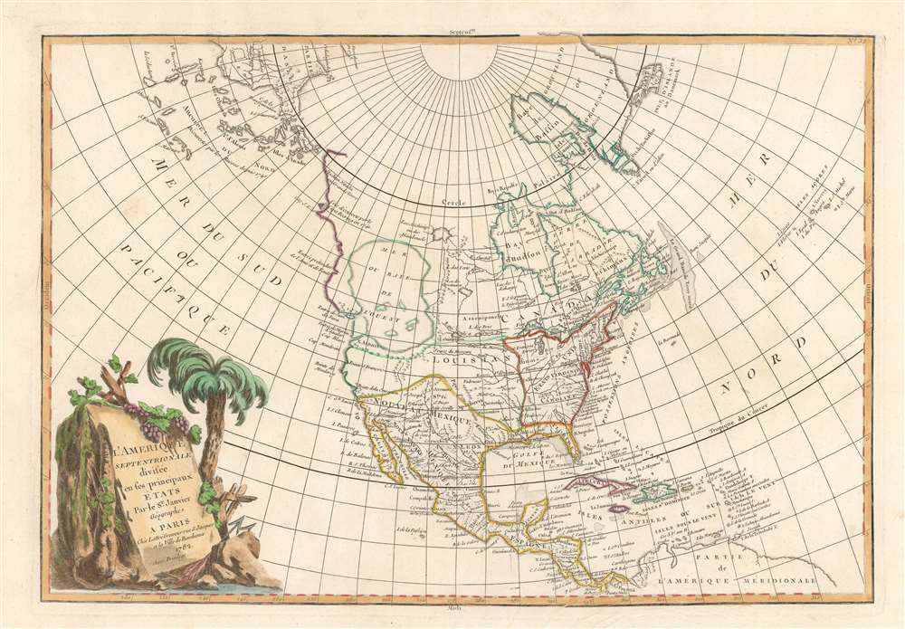
L'Amerique Septentrionale Divisee en ses Principaux Etats.
1782 (dated) 12.5 x 18 in (31.75 x 45.72 cm) 1 : 32000000
1782 (dated) 12.5 x 18 in (31.75 x 45.72 cm) 1 : 32000000
Description
An altogether fascinating example of Jean Janvier's 1782 map of North America. This is the first map in this series to name the United States. Nonetheless, the map is best known for its ambitious Sea of the West. Coverage extends from Panama to the Arctic Circle, and extends westward to include parts of Asia and eastward as far as Iceland. This map is heavily influenced by the theoretical mappings of Nicholas de l'Isle and Philippe Buache. Janvier divides the continent according to political powers: the United States (Etats Unis) occuping the former British colonies as far west as the Mississippi; Spain controlling Mexico, Florida, Central America, and Louisiana; and England controlling Canada.
Sea of the West
By far the most interesting aspects of this map deal with the largely unexplored Pacific Northwest. A magnificent sea, called the Sea of the West or in this case the 'Baye de L'Ouest,' occupies a large portion of the northwestern part of the continent. This body of water, alternatively called the 'Sea of the West' or 'Mer de l'Ouest', was speculated by Philippe Buache and Nicholas De l'Isle in the early 18th century based upon wishful thinking, American Indian stories, and the questionable 16th-century explorations of Juan de Fuca. Janvier gives the Mer de l'Ouest its fullest expression, although he specifically does not connect it to either the network of lakes and rivers extending westward from the Hudson Bay or to the similar network extending westward from Lake Superior.Discoveries of the Coureurs des Bois
These river and lake networks were being actively explored throughout the early 18th century by a number of little known but important French explorers. The explorations of the La Vérendrye brothers, for example, and other coureurs des bois, include the discovery of the Lake of the Woods (L. Des Bois) and Lake Winnipeg (L. Ouinipigon), both of which appear on this map. However, despite the activity of French explorers and fur traders, the entirety of the continent northwards of the Mississippi River watershed and the St. Lawrence River is not territorially assigned to any European Power. The French claimed all modern-day Canada, but the entire region was also part of the Hudson Bay Company's royal charter. Legally this would become much clearer in the year after this map was issued. In 1763, following the Seven Years' War, France ceded nearly all its North American territory to England. Nonetheless, this poorly policed and vast land remained hotly contested on the practical level as fur traders, backwoodsmen, and coureurs des bois flooded the wilderness in search of its most treasured commodity, beaver pelts.Bering and Proto-Alaska
Even farther to the north we recognize a novel pre-Cook / post-Bering cartography. The extreme northeast tip of Asia reflects the mid-18th century explorations of Vitus Bering and Tschirikow. The cartographer has done away with the archaic 'Strait of Anian' and the speculative Muller Peninsula in the place of a series of islands - a sort of proto-Aleutian archipelago. A large island is identified as Anadir (Anadyr), a term associated with the Chukchi peoples of northeastern Siberia. In earlier Russian maps this island is more often named 'Alaska' or some variant of the Chukchi term for 'mainland'.Publication History and Census
This map was drawn by Jean Janvier for issue in Jean Lattre's 1782 Atlas Moderne. Though most examples of this map are dated 1762, the map itself appeared in multiple states between its first edition in 1762 and final iteration in the late 1780s. We have identified at least four variants. The first edition, 1762, includes a large 'Sea of the West', a series of lakes and rivers associated with the legendary voyages of Admiral de Fonte, and the Aleutians rendered as a single landmass, a la Muller. A second variant, possibly 1775, includes the De Fonte speculation, and the 'Lake of the West', but renders the Aleutians embryonically as a series of islands. A third state (present example) issued in 1782, retains the 'Sea of the West', but does not include the De Fonte discoveries further north, and the Aleutians are embryonically rendered as individual islands. There may be still other variations we have yet to discover, including a 1771 issue and a 1783 issue. A full series of these beautifully produced maps presents a thorough overview of the conceptual development of the American northwest prior to Cook.CartographerS
Jean Denis Janvier (fl. 1746 - 1776), sometime also known as 'Robert', was a Paris based cartographer active in the mid to late 18th century. Janvier signed his maps Signor Janvier. By the late 18th century, Janvier was awarded the title of 'Geographe Avec Privilege du Roi' and this designation appears on many of his later maps. Janvier worked with many of the most prominent French, English and Italian map publishers of his day, including Longchamps, Faden, Lattre, Bonne, Santini, Zannoni, Delamarche, and Desnos. More by this mapmaker...
Jean Lattré (170x - 178x) was a Paris based bookseller, engraver, globe maker, calligrapher, and map publisher active in the mid to late 18th century. Lattré published a large corpus of maps, globes, and atlases in conjunction with a number of other important French cartographic figures, including Janvier, Zannoni, Bonne and Delamarche. He is also known to have worked with other European cartographers such as William Faden of London and the Italian cartographer Santini. Map piracy and copyright violations were common in 18th century France. Paris court records indicate that Lattré brought charges against several other period map publishers, including fellow Frenchman Desnos and the Italian map engraver Zannoni, both of whom he accused of copying his work. Lattré likes trained his wife Madame Lattré (né Vérard), as an engraver, as a late 18th century trade card promotes the world of 'Lattré et son Epouse.' Lattré's offices and bookshop were located at 20 rue St. Jaques, Paris, France. Later in life he relocated to Bordeaux. Learn More...
Source
Lattre, Jean, Atlas Moderne ou Collection de Cartes sur Toutes les Parties du Globe Terrestre, (Paris) 1782.
Condition
Very good condition. Original centerfold.
References
Phillips (Atlases) 629-33. Wagner, H. R., The Cartography of the Northwest Coast of America to the Year 1800, 559. Wheat, C. I., Mapping of the Transmississippi West, 1540 - 1861, 192. Sellers, J. R. and Van Ee, P. M., Maps and Charts of North America and the West Indies 1570-1789, 93. McGuirk, D., The Last Great Cartographic Myth: Mer de l'Ouest, no. 109. Lowery, W., The Lowery Collection: A Descriptive list of Maps of the Spanish Possessions within the present limits of the United States, 1502 - 1820, 663. Sellers J., and Van Ee, P., Maps and Charts of North America and the West Indies, 1750 - 1789, 93.