1791 Johnson and Dalton Map of the Ancholme River in Lincolnshire, England
Ancholme-johnsondalton-1791$500.00


Title
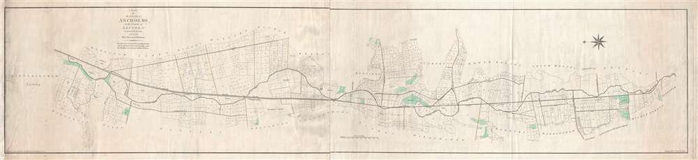
A Plan of the Level of Ancholme in the County of Lincoln. As Survey'd in the Years 1767 and 1768 by E. Johnson and J. Dickinson.
1791 (dated) 15 x 66 in (38.1 x 167.64 cm) 1 : 19800
1791 (dated) 15 x 66 in (38.1 x 167.64 cm) 1 : 19800
Description
This is a 1791 E. Johnson and I. Dalton map of the Ancholme River in Lincolnshire, England. The map depicts from Winteringham Lordship to Glentham. Both the Old River Ancholme and the New River are illustrated. The 'new' was created to address regular flooding of the 'old' Ancholme. As all the highlands in the area are noted by green shading, it is evident that, if the Ancholme did flood, a large majority of landowners were at risk. Plots of land are illustrated and labeled numerically all along the length of the river, along with several drains and dykes.
Census and Publication History
This map was originally laid down by E. Johnson and J. Dickinson after they had completed their survey in 1768. E. Johnson and I. Dalton reduced the map for this publication in 1791, which was engraved by John Cary. We have been unable to locate any examples of this map in institutional collections and have only been able to trace two instances where it appeared on the private market in recent years.Condition
Very good. Two sheets joined near center. Wear along created centerfold.
References
British National Archives YARB 4/25/1-3.