1850 Delamarche Map of the Ancient World: Europe, Africa, Asia
AncientWorld-delamarche-1850$150.00

Title
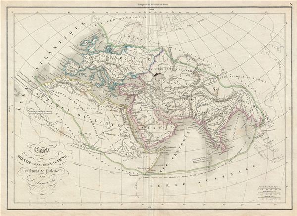
Carte du Monde Connu des Anciens au Temps de Ptolemee.
1850 (undated) 12.5 x 17.5 in (31.75 x 44.45 cm)
1850 (undated) 12.5 x 17.5 in (31.75 x 44.45 cm)
Description
This is a beautiful example of Alexandre Delamarche's 1850 map of the ancient world, including Asia, europe and Africa. The map shows the world of antiquity from the Atlantic Ocean to Burma in Asia and from the Indian Ocean to the North Sea. It includes all of europe, Arabia, parts of Asia including the Indian Subcontinent, and the northern part of Africa. The extent of ancient geographical knowledge is identified by a green line running just south of Scandinavia, across northern europe, then southeast, skirting the southwestern border of China, but embracing India, Burma, and Siam, though not Malay, then laterally bisecting the Indian Ocean and running northwest just south of the Sahara to meet the Atlantic in Morocco. A more contemporary geography in ghosted in beyond the green line to give readers better context. Throughout, the map identifies various cities, towns, rivers, mountain passes and an assortment of additional topographical details. Political and regional borders are highlighted in outline color. This map was issued by Delamarche as plate no. 5 in his Atlas Delamarche Geographie Modern.
Cartographer
Charles-François Delamarche (August 1740 - October 31, 1817) founded the important and prolific Paris-based Maison Delamarche map publishing firm in the late 18th century. A lawyer by trade, Delamarche entered the map business with the 1787 acquisition from Jean-Baptiste Fortin of Robert de Vaugondy's map plates and copyrights. Delamarche appears to have been of dubious moral character. In 1795, the widow of Didier Robert de Vaugondy, Marie Louise Rosalie Dangy, petitioned a public committee for 1500 livres, which should have been awarded to her deceased husband. However, Delamarche, proclaiming himself Vaugondy's heir, filed a simultaneous petition and walked away with the funds, most of which he was instructed to distribute to Robert de Vaugondy's widow and children. Just a few months later, however, Delamarche proclaimed Marie Dangy deceased, and it is highly unlikely that any funds found their way to Robert de Vaugondy's impoverished daughters. Nonetheless, where Robert de Vaugondy could barely make ends meet as a geographer, Delamarche prospered as a map publisher, acquiring most of the work of earlier generation cartographers Lattre, Bonne, Desnos, and Janvier, thus expanding significantly upon the Robert de Vaugondy stock. Charles Delamarche eventually passed control of the firm to his son Felix Delamarche (c. 1750 - c. 1850) and geographer Charles Dien (1809 - 1870). It was later passed on to Alexandre Delamarche, who revised and reissued several Delamarche publications in the mid-19th century. The firm continued to publish maps and globes until the middle part of the 19th century. More by this mapmaker...
Source
Delamarche, A., Atlas Delamarche Geographie Ancienne et Moderne, (Paris) 1850.
Condition
Very good. Some wear on original centerfold. Blank on verso. Minor ink stain over the Caspian Sea.