1790 Map of Asia
Asia-anonymous-1790$350.00

Title
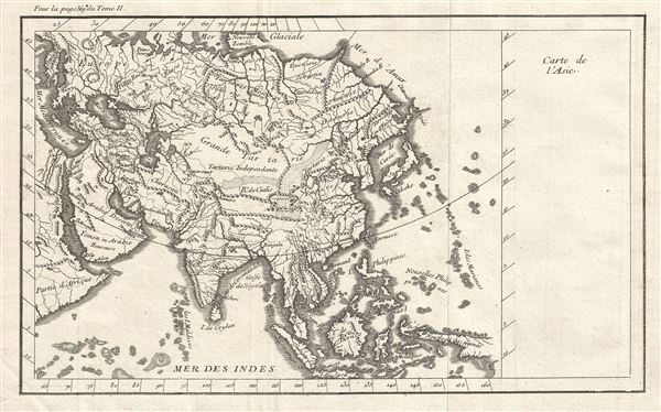
Carte de l'Asie.
1790 (undated) 10 x 15.5 in (25.4 x 39.37 cm) 1 : 43000000
1790 (undated) 10 x 15.5 in (25.4 x 39.37 cm) 1 : 43000000
Description
This is a fascinating late 18th century map of Asia of unknown origins. It covers the entire continent from the Mediterranean Sea and Africa east to Japan and New Guinea. This map is most interesting in its rendering of the largely unexplored extreme northeast of Asia. Knowledge of this area was, at the time, speculative at best. Hokkaido, or as it is mapped here, Edo or Yesso, is joined to Sakhalin and is connected to the mainland of Asia, reflecting a common misunderstanding about this region that persisted until the late 18th century, referring to the cartography of Maerten de Vries and Cornelis Jansz Coen.
Just to the east of Yesso, separated by the Detroit d'Vries, is an unnamed landmass. This is most likely Terre de La Compagnie or Gamma Land, a mysterious island appearing on maps from this period. Terre de la Compagnie, sometimes also called Gamma Land, is essentially an embryonic mapping of the Kuril Islands. These islands were discovered by Maerten de Vries and Cornelis Jansz Coen's, who explored this land in 1643 in search of the gold and silver rich islands mentioned in a Spanish legend. Vries and Coen were the first Europeans to enter these waters, which were in fact little known even to the Japanese. They mapped the Strait of Vries. They believed this strait to separate Asia from America, which Compagnies Land formed part of, thus elucidating its magnificent proportions. Various subsequent navigators claim to have seen these lands, but it was left to Vitus Bering to finally debunk the myth. In 1729, Bering spent three days in the region looking Compagnie Island but never found it. These curious islands remained on maps for about 50 years following Bering's voyages until the explorations of Cook confirmed his findings.
Vries and Coen were also the first European navigators to discover Sakhalin and map its southern coastline. Apparently the Castricum was mired in a heavy fog as it attempted to explore these seas and thus Vries and Coen failed to notice the strait separating Yesso (Hokkaido) from Sakhalin, initiating a cartographic error that would persist well into the 18th century. Despite their many successes, the expedition ultimately failed to discover islands of silver and gold, thus proving definitively to Van Diemen that indeed, no such lands ever existed.
The sea between Japan and Korea, whose name, either the 'Sea of Korea,' 'East Sea,' or the 'Sea of Japan,' is here identified in favor of Korea (Mer de Coree). Historically, Korea has used the term 'East Sea' since 59 B.C., and many books published before the Japanese annexed Korea make references to the 'East Sea' or 'Sea of Korea.' Over time, neighboring and western countries have identified Korea's East Sea using various different terms. The St. Petersburg Academy of Sciences referred to the East Sea as 'Koreiskoe Mope' or 'Sea of Korea' in their 1745 map of Asia. Other seventeenth and 18th century Russian maps alternate between 'Sea of Korea' and 'Eastern Ocean.' The 18th century Russian and French explorers Adam Johan von Krusenstern and La Perouse called it the 'Sea of Japan,' a term that became popular worldwide. Nonetheless, the last official map published by the Russians name the East Sea the 'Sea of Korea.' The name is currently still a matter of historical and political dispute between the countries.
Overall, a fascinating French map from the late 18th century.
Condition
Very good. Original fold lines visible.