1845 Ewing Map of Asia
Asia-ewing-1845$150.00

Title
Asia.
1845 (undated) 8 x 9.5 in (20.32 x 24.13 cm) 1 : 62000000
1845 (undated) 8 x 9.5 in (20.32 x 24.13 cm) 1 : 62000000
Description
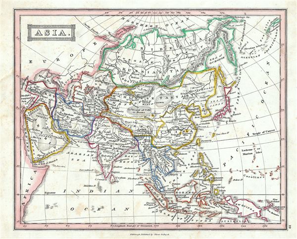
This is a beautiful example of Thomas Ewing's 1845 map of Asia. The map covers the entire Asian continent from the Arctic Ocean to the Indian Ocean and from the Mediterranean Sea to the North Pacific Ocean. It shows Turkey, Arabia, Persia, the Indian subcontinent, Russia, Independent Tartary, Chinese Tartary, Japan and parts of Southeast Asia. The Great Wall of China and the Grand Canal are identified. The sea between Asia and Japan, whose name is a matter of political debate (either the 'Sea of Korea,' 'Sea of Japan') is here settled in favor of Japan. Throughout, the map identifies various cities, towns, rivers and assortment of additional topographical details.
As this map was drawn, Imperial China wilted under the weak Qing while the Russian attained the height of its pan-continental expansion. Turkey and much of the Middle East were under Ottoman hegemony.
In the early 19th century Asia was coming under increasingly imperial European sway. In India, full British rule allowed England to attain naval and trade supremacy throughout the eastern Hemisphere. Using India as a springboard, the English traded wool and Indian cotton for Chinese tea and textiles. By the 1830s oversaturation of the Chinese market slackened Chinese demand for most British products. To make up for the trade deficit, British merchants introduced Indian opium to China. Addictive and cheap, Opium became Britain's most profitable and important crop in world markets, pouring into China faster than tea poured into Britain. Opium addiction and its attendant social ills reached such catastrophic levels that the Chinese government took action and destroyed British opium stores in Canton. As this threatened English commercial interests, the crown responded, sparking the Opium Wars of 1839-1842. The superior British forces took complete control of Canton, occupied Shanghai, and blockaded Chinese ports, forcing the Chinese to sign the 1842 Treaty of Nanking. This unequal treaty (the first of many between European powers and China) granted Britain extensive trading rights in China.
This map was published in 1845 by Oliver and Boyd as part of Ewing's New General Atlas.
Source
Oliver and Boyd, Ewing's New General Atlas: containing Distinct Maps of all the Principal States and Kingdoms throughout the World, (Edinburgh) 1845.
Condition
Very good. Minor foxing at places. Blank on verso.