This item has been sold, but you can get on the Waitlist to be notified if another example becomes available, or purchase a digital scan.
1669 Sanson Map of Asia
Asia-sanson-1669$325.00

Title
L'Asie.
1669 (dated) 17 x 23.25 in (43.18 x 59.055 cm) 1 : 24000000
1669 (dated) 17 x 23.25 in (43.18 x 59.055 cm) 1 : 24000000
Description
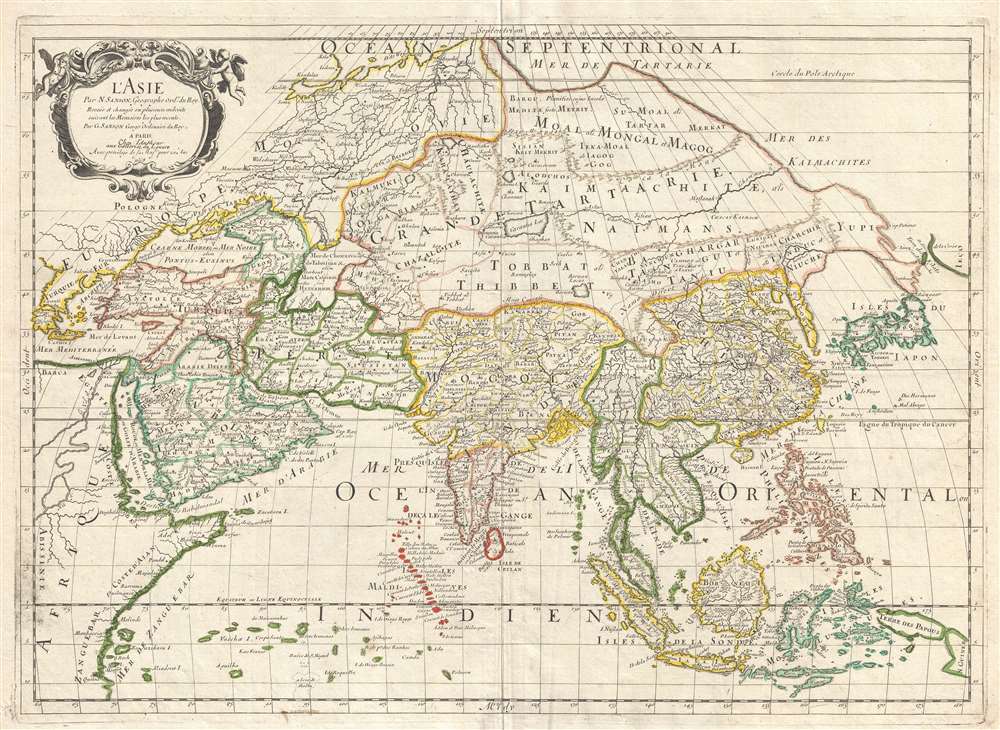
This is a 1669 Nicolas and Guillaume Sanson map of Asia. Overall an unusual projection and centered on Tibet, the map depicts the entire continent of Asia from Greece to the Kurile Islands and from the Arctic Ocean to New Guinea, including parts of Europe and Africa. This represents the second edition of the Sanson map of Asia, with one notable difference being the depiction of Korea as an elongated peninsula, whereas in the first edition Korea was shown as an island. Other aspects of East Asian geography, however, remain fairly speculative. Hokkaido is illustrated as being attached to the mainland as part of a vast peninsula called Yupi (Sakhalin). Separated from the landmass by the narrow Strait of St. Vries is a mysterious landmass labeled as Ieco, a name which itself is commonly associated with Hokkaido. Here, Sanson has moved the toponymy further east and attached it to an oversized mapping of the Kuril Islands. It is also important to note the incomplete depiction of New Guinea.
This map was created by Nicolas Sanson and republished by his son Guillaume Sanson in 1669.
Aprocryphal Lake Chiamay
Another important aspect of this map's cartography is the inclusion of the mythical Lake of Chiamay, here located in southeast Asia near the border with India and Tibet. Early cartographers postulated that such a lake must exist to source the four important Southeast Asian river systems: the Irrawaddy, the Dharla, the Chao Phraya, and the Brahmaputra. This lake began to appear in maps of Asia as early as the 16th century and persisted well into the mid-18th century. Its origins are unknown but may originate in a lost 16th century geography prepared by the Portuguese scholar Jao de Barros. It was also heavily discussed in the journals of Sven Hedin, who believed it to be associated with Indian legend that a sacred lake, Mansarovar, linked several of the holy subcontinent river systems. There are even records that the King of Siam led an invasionary force to take control of the lake in the 16th century. Nonetheless, the theory of Lake Chiamay was ultimately disproved and it disappeared from maps entirely by the 1760s.This map was created by Nicolas Sanson and republished by his son Guillaume Sanson in 1669.
Cartographer
Nicolas Sanson (December 20, 1600 - July 7, 1667) and his descendants were the most influential French cartographers of the 17th century and laid the groundwork for the Golden Age of French Cartography. Sanson was born in Picardy, but his family was of Scottish Descent. He studied with the Jesuit Fathers at Amiens. Sanson started his career as a historian where, it is said, he turned to cartography as a way to illustrate his historical studies. In the course of his research some of his fine maps came to the attention of King Louis XIII who, admiring the quality of his work, appointed Sanson Geographe Ordinaire du Roi. Sanson's duties in this coveted position included advising the king on matters of geography and compiling the royal cartographic archive. In 1644, he partnered with Pierre Mariette, an established print dealer and engraver, whose business savvy and ready capital enabled Sanson to publish an enormous quantity of maps. Sanson's corpus of some three hundred maps initiated the golden age of French mapmaking and he is considered the 'Father of French Cartography.' His work is distinguished as being the first of the 'Positivist Cartographers,' a primarily French school of cartography that valued scientific observation over historical cartographic conventions. The practice result of the is less embellishment of geographical imagery, as was common in the Dutch Golden Age maps of the 16th century, in favor of conventionalized cartographic representational modes. Sanson is most admired for his construction of the magnificent atlas Cartes Generales de Toutes les Parties du Monde. Sanson's maps of North America, Amerique Septentrionale (1650), Le Nouveau Mexique et La Floride (1656), and La Canada ou Nouvelle France (1656) are exceptionally notable for their important contributions to the cartographic perceptions of the New World. Both maps utilize the discoveries of important French missionaries and are among the first published maps to show the Great Lakes in recognizable form. Sanson was also an active proponent of the insular California theory, wherein it was speculated that California was an island rather than a peninsula. After his death, Sanson's maps were frequently republished, without updates, by his sons, Guillaume (1633 - 1703) and Adrien Sanson (1639 - 1718). Even so, Sanson's true cartographic legacy as a 'positivist geographer' was carried on by others, including Alexis-Hubert Jaillot, Guillaume De L'Isle, Gilles Robert de Vaugondy, and Pierre Duval. More by this mapmaker...
Condition
Very good. Light wear along original centerfold. Closed margin tear professionally repaired on verso. Blank on verso.
References
OCLC 801687591.