This item has been sold, but you can get on the Waitlist to be notified if another example becomes available, or purchase a digital scan.
1784 Bocage Map of Athens, Greece
Athens-bocage-1784$100.00

Title
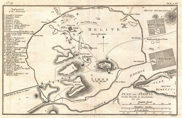
Plan of Athens, for the Travels of Anacharsis, May 1784.
1784 (dated) 8.5 x 12.5 in (21.59 x 31.75 cm)
1784 (dated) 8.5 x 12.5 in (21.59 x 31.75 cm)
Description
This is an attractive 1784 map of ancient Athens, Greece. Covering the walled center of ancient Athens, this map details the ancient city's most important buildings and monuments. Names the Lyceum (Aristotle's famous school of philosophy) and the Cynosarges (Public gymnasium) as well as the Forum, the Citadel, the Temple of Theseus, and the Areopagus. Prepared by Barbie de Bocage for publication in the atlas volume attached to Jean Jacques Barthelemy's 1788 Travels of Anacharsis the Younger in Greece.
Cartographer
Jean Denis Barbie du Bocage (1760 - 1825) and his son Jean-Guillaume Barbie du Bocage (1795 - 1848) were French cartographers and cosmographers active in Paris during late 18th and early 19th centuries. The elder Barbie du Bocage, Jean Denis, was trained as a cartographer and engraver in the workshops of mapmaking legend J. B. B. d'Anville. At some point Jean Denis held the post of Royal Librarian of France and it was through is associations with d'Anville that the d'Anville collection of nearly 9000 maps was acquired by French Ministry of Foreign Affairs. The younger Barbie du Bocage, Jean-Guillaume, acquired a position shortly afterwards at the Ministry of Foreign Affairs and, in time, became its head, with the title of Geographe du Ministere des Affaires Etrangeres. More by this mapmaker...
Source
Barthelemy, J. J., Atlas to Accompany The Travels of Anacharsis the Younger in Greece, 1788.
Condition
Very good. Original centerfold. Blank on verso.