1837 Direccion Hidrografia Nautical Chart / Map of the Atlantic Ocean
Atlantico-direccionhidrografia-1851$1,000.00

Title
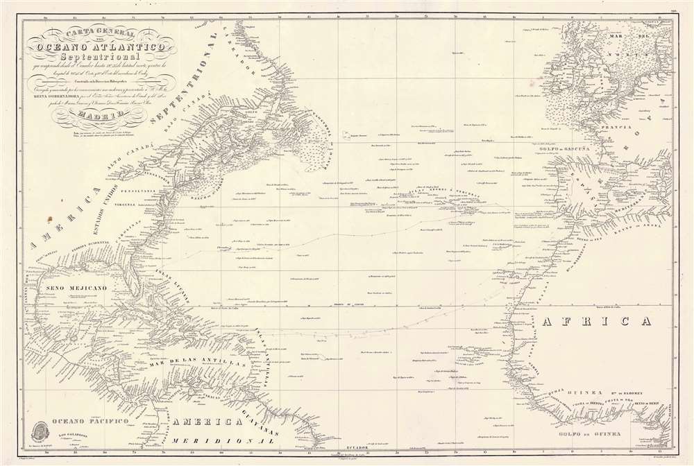
Carta General del Oceano Atlantico Septentrional que comprende desde el Ecuador hasta 55° 35' de latitud norte, y entre la longitud de 93° 45' al Oeste, y 17° al Este del meridiano de Cadiz.
1851 (dated) 25 x 37.25 in (63.5 x 94.615 cm)
1851 (dated) 25 x 37.25 in (63.5 x 94.615 cm)
Description
This is a rare 1837 / c. 1851 Direccion Hidrografía nautical chart or maritime map of the Atlantic Ocean with manuscript notations relating to an 1864 voyage from Cadiz to Havana. Coverage extends from Labrador and the North Sea to the Equator, and from the Gulf of Mexico to the Mediterranean. The chart offers meticulous coastal detail throughout, as well as interesting annotations regarding sighting of rocks, banks, and reefs sighted along the central route between Europe and America. Such charts were used for broad voyage planning and open sea, smaller more detailed charts were then used for approaches to land.
The Voyage of the Andaluza
Pencil marks trace the route of the February - March 1865 voyage of the Andaluza, a Covadonga class Screw Schooner in the Spanish Navy built specifically for the Cuba route - decommissioned in 1865. There appear to have been two ships that left Cadiz at the same time and voyaged mostly within sight of one another as far as the Virgin Islands. This 'caravanning' was a common maritime practice, as it offered ships the opportunity to support one another on the long passage, and additional defense against piracy. It is possible at this point that the ships parted ways, as afterwards, the track of only one ship is recorded as it makes its way to Havana, then between Florida and the Bahamas before setting out for open sea and Europe.Publication History and Census
This large nautical chart was first published in 1837 by the Spanish Direccion Hidrografía. The map was drawn by José Espejo Y Carré and engraved in Madrid by Clemente Noguera, with lettering added by Manuel Giraldos. Although no further publication date appears on the map, we note updates to about 1851. Appears from time to time on the market.CartographerS
The Direccion Hidrografía (1787 - 1927), also known as the Deposito Hydrografico and the Direction de Hidrografía, was the Spanish equivalent of the British Admiralty or the U.S. Coast Survey. This organization, founded in 1787, was commissioned to collect and produce accurate nautical charts of all waters frequented by Spanish vessels. In essence, it replaced the Casa de la Contratación de las Indias (House of Trade of the Indies), which closed its doors in 1790. Like most such organizations, the Direccion Hidrografía marked a new age in cartography. Rather than simply collect charts created by navigators, explorers, and merchants, the Direccion Hidrografía worked closely with naval and military personnel to mount cartographic and hydrographic expeditions in pursuit of the most accurate hydrographical, astronomical, and geodetic measurements. The Direccion Hidrografía created a massive library of nautical charts that, though not nearly as common as similar nautical charts by the U.S. Coast Survey and British Admiralty, are highly desirable for the beauty of their manufacture as well as their accuracy and detail. The office was originally located on Calle Ballesta, but relocated to 36 Alcala, both in Madrid. After 1908 the Dirección was subsumed into other governmental agencies. In 1927 the Direccion was absorbed into the Institute and Observatory of San Fernando, located in Cadiz. The library of original maps, charts, and journals was transferred to the Naval Museum of Madrid - where it resides to this day. More by this mapmaker...
José Espejo Y Carré (fl. c. 1829 - 1857) was a Spanish sea captain, naval officer, navigator, and draftsman active in Madrid during the middle part of the 19th century. He may have been stationed in Cartagena as early as 1829. Espejo is identified in 1852 a Senior Draftsman with the Dirección Hidrografía. Learn More...
Clemente Noguera (fl. c. 1809 – 1860) was a Spanish draftsman, naval pilot, and engraver based in Madrid during the middle part of the 19th century. Little is known of Noguera, but he was active as an engraver as early as 1809, when he engraved a plan of Zaragoza, Spain. He was a second lieutenant of the Spanish Navy in 1830. By, 1850, Noguera was a senior draftsman for the Direccion de Hidrografia. Clemente Noguera should not be confused with Juan Noguera, who was also a senior line-engraver at the Direccion de Hidrografia. The two engravers may or may not be related. Clemente was significantly older than Juan, and may have been an older relative. Learn More...
Manuel Giraldos (fl. c. 1830 - 1850) was a copper and line and letter engraver active in Madrid during the early to middle parts of the 19th century. Giraldos studied engraving under José Asensio. He worked extensively as a letter engraver for the Dirección Hidrografía. Learn More...
Condition
Very good. Pencil marks recording c. 1867 trans-Atlantic voyage.